Battlefield Guide Services

Wednesday, September 30, 2020

The Death of General Thomas Stevenson. Identifying the ground where he fell.


The following is the culmination of a project I began over sixteen years ago, brought out again currently by the expressed desire of others to place a historical marker pertaining to the death site of Brigadier General Thomas Greeley Stevenson. Since early 2004 I have studied the terrain around which he was killed and the documentation that exists detailing the incident. Many thanks to historian Eric Mink of the Fredericksburg and Spotsylvania National Military Park for providing access to copy documents within their holdings. Also, in remembrance of the late historian Greg Coco, I want to acknowledge his kind generosity in fielding my questions back in 2007, and his providing copied pages from his book, Through Blood and Fire. They served as the first strong clue supporting my assertions herein.

All images can be tapped for enlarged viewing.


Introduction 

Around 8:30 on the morning of May 10, 1864, Brigadier Thomas Greely Stevenson was relaxing under a tree behind an advanced defensive position on the south side of the Fredericksburg and Spotsylvania Courthouse Road, modern Route 208. The general and some fellow officers had just finished breakfast and he was reclined on his right elbow, smoking his pipe. Several eyewitness accounts of the details behind this incident exist. Some are confusing, others contradictory and easily dismissed, leaning toward hearsay, while others, taken together, paint the scene vividly. Numerous pedestrian terrain surveys, accompanied by the maps of  topographical engineers Nathaniel Michler and James Duane, as well as a vivid, on-location sketch of the landscape by newspaper Special Artist, Alfred Waud, helped to verify, for me, the vicinity in relation to the written accounts.

Stevenson's Arrival On The Field

At the conclusion of the costly two-day fight in the Wilderness, the Union Army started its way toward the Spotsylvania Courthouse during the evening of May 7, 1864. In the morning hours of May 8, the 5th and 6th Corps arrived northwest of the village on the edge of the Spindle Farm, while the 2nd Corps made an a extension of the Union right, nearly three miles to the west, crossing the Po River. Over May 8 and 9, the 9th Corps approached along the Fredericksburg Road, heading southwest, having made a circuitous route, part of a plan desiring to trap Lee's army in a bag, but this was ultimately due to fail as delays along the path curtailed the left wing's part of the action. 

The 9th Corps' had established a foothold south of the Ni River (spelled Ny in 1864, and the cause of some confusion, with erroneous speculation that it stood for the "New York" River). The Third Division, under General Willcox, had engaged Confederates on the Beverly Farm, known as Whig Hill, in the morning hours of May 9, along with scattering units atop the rise coming out of the Ni River valley on the Couthouse Road. The Confederates withdrew after a strenuous firefight. Near noon, the First Division, under General Stevenson, arrived, pressing forward, beyond Whig Hill, to an advanced position within a half mile of the entrenched Confederates on the rise around Spotsylvania Courthouse. For the remainder of the day skirmishers exchanged fire, the Confederates having advanced theirs near 300 yards to the front of their main line. At some point, newspaper artist Alfred Waud witnessed, and sketched, advancing 9th Corps troops, engaging the Confederate pickets semi-concealed in a line of "dwarf pine".

The ground in front of the Spotsylvania Courthouse advance

A panoramic view toward Spotsylvania Courthouse, made from two photographs taken March 25, 2004.
The author was able to achieve this in the days before readily available drone photography, by the kind assistance of Spotsylvania Fire Company/Rescue Station 1, and the use of their truck, Tower 1. Company 1 is now located in the open foreground seen in this image, the historically important ground over which the 9th Corps advanced on May 9, 1864. The advance was witnessed and drawn by Harper's Weekly Special Artist, Alfred Waud, as seen in the next image and comparative ground-level photograph assembled, also by the author, in his early investigations of the site. Annotations are added in red to orient the location of buildings around the Courthouse. A prior blog post from April 2010 goes into further details on this point.


The ground's appearance on May 10 is described by Lieutenant Edwin Rufus Lewis in his reminiscences after the war. "...the men were getting into shape on the high slope facing a long depression beyond which was the gentle rise..." upon which was the entrenched Confederate position in advance of the Courthouse. Lewis was on detached duty from his regiment, the 21st Massachusetts, serving as Aid de Camp for General Stevenson. Waud's sketch makes note of action on May 9th, with "Rebels firing from the dwarf pine on the slope to the ct. house". Waud may have used a slight elevation to observe this action, perhaps from a tree. Another sketch by Waud exists, showing greater details of the structures around the Court House, undoubtedly observed with the aid of binoculars or a telescope. That drawing is shown below. Space considerations compelled Waud to draw the left side details of what he observed at the top of the page, then proceeding to the right hand structures on the bottom half. This was very likely drawn on May 9th as well. The Confederate entrenched position is indicated by the dashed line on the rising slope indicated on the top half.

The images were later cobbled together to create the wood engraving below, published in Harper's Weekly, on page 380 of their June 11, 1864 issue.


Major Charles J. Mills of the 56th Massachusetts, of the 1st Brigade, 1st Division, described the arrival and disposition on May 9. "Gen. Wilcox's Headquarters were well in rear, and Gen. Stevenson was sent to take command in front, and the Division posted principally in reserve. Strong entrenchments were immediately begun, as the enemy have a very strong position in front. There was some skirmishing in front all the rest of the day, but nothing to speak of, and we had a quiet night."


The Morning of May 10, 1864

Stephen Weld affirms Stevenson's location on the "left of the road were three or four terraces, and he was lying down under one of them". Major Mills states that headquarters was "behind a bank where we were perfectly protected."
Stevenson was lying on a blanket spread out under the shade of a tree, smoking his pipe and looking relaxed. This was noticed by fellow officers who had ridden forward, remarking that they would enjoy switching places. That is where most retellings of the story are similar, with Stevenson being killed suddenly, at that moment, rather akin to the immediacy of General Sedgwick's death by sniper, nearly 24 hours previous, while laughing at his own joke. The most graphic, and in all likelihood, the most accurate accounting of Stevenson's death was penned by his Aid de Camp, Lieutenant Edwin Rufus Lewis, who immediately went to the stricken general's assistance. Lewis was in post-war years trained as a physician and a chemist at Harvard Medical College, graduating in 1867, thus I am trusting of his medical assertions. 
"We had breakfasted and had had coffee and the general was enjoying his pipe reclining on the ground and resting on his right elbow, his head and upper body up, when report came that some of our men being killed in action had been left uncared for. Stevenson began to give us an order for having proper care taken of the bodies. He removed his pipe and began speaking. I stood near listening to him. Stray bullets were coming over and whistling around, burying themselves in the ground. It was a part of our routine experience. One was heard coming that seemed to be VERY near. The general stopped in the middle of a sentence. I heard the bullet strike with a peculiar dull thud as if striking in a pumpkin. I stood waiting the completion of the order. But the general was silent. He had not moved. He was holding his pipe up in hand and looking me in the face. No movement of hand or eye betrayed him, but soon his hand began to drop and his head to droop. Lieut Jones, an aide standing near by, exclaimed "Good God! the general is struck." I sprang forward and put my hand under his head to support it and felt a gruesome damp liquid oozing out. The ball had entered back of the left ear. On searching we saw it pushing out below the right temple. It had passed through the brain but had stopped short of emerging. The general never knew what hit him. He was unconscious, of course, and soon a comative sleep developed. In an hour or so he died."
As to the location on the ground, a soldier in Company A of the 100th Pennsylvania, Joseph H. Templeton, is quoted as saying the Division Headquarters was near his company. The 100th probably held the left most section of the line that day, along with the 3rd Maryland and the 21st Massachusetts.  
At 9 AM, Brigadier General Willcox, commanding the Third Division, notified Burnside that Stevenson had been killed, "at his headquarters in front".


Position Abandoned May 11

Stevenson's breastworks of the morning of May 10th would be the first of two "abandoned" works encountered late in the day of May 12, when two Confederate brigades advanced northeast along the Fredericksburg Road, before encountering an effectively held third line along what is now NPS road, Burnside Drive, on the north side of Route 208, and Wild Turkey Road, entering the Plantation Forest Subdivision on the south side of Route 208. In 1864 there was a road on nearly the same footprint as Wild Turkey, referenced in local documents as the "Anderson Road", running southeast before branching, the northern most fork moving east to cross the Ni River below the Anderson Plantation on a plateau on the north side of the Ni. The southern fork swung to the south, downhill, then swung back southeast into the property of John Henry Myer and the landmark known as "Myer's" or "Bleak" Hill.

Maps

This aerial view is annotated to illustrate the three lines (vibrant blue) encountered by the "Cooke - Weisiger Advance" of May 12, along the Courthouse Road. 1 and 2 have been described as "abandoned" or lightly held by skirmishers, whereas 3 was strongly held and caused the Confederates to fall back.

Here is a detail of the area from the Michler map, showing the entrenched positions along the road.


Below is a focus on the location of the forward line, and position of General Stevenson's death. Based heavily on pedestrian surveys by myself, and line of site considerations, I have based my conclusions that a slightly elevated position at the center of the line, inside the "S" curve, would be the logical place of Stevenson's headquarters, "at the front", as it is referred to. Based on the stated nearness to the 100th Pennsylvania in line, I would suggest they occupied the eastern wing. Headquarters then, and the remnant of trench it sat behind, is sadly the location of a decades-old trash dumping ground, outlined in white, with an old dirt path marked through its center. By all appearances, the ditch of the trench may have been initially used as a ready-made dumping ground. Estimates of its use may be 50 years or more, considering the items visible when toured around 15 years ago. Modern (current, assumed) property lines are indicated in red. Further examination would prove beneficial, but it must be pointed out that this is all private property. The scene of the fighting in Waud's May 9 sketch is across Courthouse Commons Boulevard, across the ground now occupied by Spotsylvania Fire Company/Rescue Station 1, and the 1960s vintage pond seen to the southwest corner of the map. The Confederate skirmishers detailed in the Waud sketch would have been along what is now the driveway leading to the Confederate Cemetery.

In an ideal world, my suggestion to locate proposed interpretive markers for this ground would ideally be in the open field just north of the 1960s pond, on the Fire Station property, largely on the visual strength of the Waud sketch and comparative graphics that can be provided.

I will point out that interestingly, the troop movement map set produced by National Park Service researchers in 2000, usually referred to as the "O'Reilly maps", does not indicate the existence of this forward trench line. Similarly, the much older "Happel and Bearrs" map set from around 1950, shows the existence of the line only on the last two maps of the set, without further notes.

Conclusion

It is my belief, based on documents indicating Stevenson was sent, and took command, in the "front", whereas others were in the "rear", and the on-site, as it happened, visual strength of the Waud drawing of advancing Union soldiers across the ground, dated as the 9th of May 1864, this is the location of Stevenson's death on May 10. The site would be the ideal "military crest" from which to observe and engage the enemy, roughly 500 yards (skirmishers), and 800 yards (entrenched) to his front.


Copyright © 2004-2020 by John F. Cummings III


Tuesday, May 26, 2020

Fox House Below The North Anna: The front has always been the front. Concern raised as restoration work nears.

Last May the Emerging Civil War blog published a piece about the American Battlefield Trust's acquisition of the Fox House, a vital landmark of the North Anna Campaign, and location of a near fatal blow to Robert E. Lee himself. In that article there was raised the question as to which face of the house, east or west, was the 1860's entrance. The answer to that question is easily established, yet a few days ago, May 23, 2020, ECW posted an on-site video, now revised as of 5/28/2020), with co-founder and editor-in-chief, Chris Mackowski, wherein he presents the west face of the house as being the wartime entrance, maintaining that this was due to the wartime placement of the Telegraph Road being some 250 yards distant, Mackowski further maintains that the entrance was switched to the east face with the 1926 opening of modern U. S. Route 1, alternately known as the Jefferson Davis Highway, and Washington Highway. This assertion does not bear up under scrutiny. There are two major points to be brought forth here.

Point 1: When built in the mid to late 1830's, the front of the house was oriented toward the newly opened (1836) Richmond, Fredericksburg and Potomac Railroad, which took dominance over the Telegraph Road as the anticipated route of burgeoning commerce. It also didn't hurt that facing east provided morning sun and added warmth during winter months. This trended into the mid 19th century.

Point 2: The incident of General Robert E. Lee's near brush with death on May 23, shortly after 5:00 PM, left physical evidence on the left door frame of the east face entrance way. The story places the general on the porch, receiving a cold glass of buttermilk from the home's owner, Reverend Fox, just as a Union artillery shell hits the frame and fails to explode. A photograph of that battle damaged wood, taken by me in 1992, can be seen below, at center, along the edge of the brick wall.

I'm confident the Trust is aware of the Fox House entrance being on the east side rather than the alternate story initially detailed in the ECW video. 
From the ECW video it is apparent the Trust has the door and frame protected by a boxed enclosure, not only as a security measure, but one to also protect the battle-scarred woodwork.

Additional images of the Fox House are included below, taken in 1992 while touring with Blue & Gray Magazine editor, Dave Roth, and North Anna battle expert, J. Michael Miller, author of the seminal volume, The North Anna Campaign "Even To Hell Itself", published in 1989 by H. E. Howard. Our visit was in preparation for Miller's cover article for the April 1993 issue of Blue & Gray.


 Jason Lee Roth (David's dad and tour assistant), historian Mike Miller, and David E. Roth, publisher of Blue & Gray, approach the east facing front porch of the house.
To the left of the house (south) stands the former library and school maintained by Reverend Fox.
Later in the day, J. Michael Miller and David Roth posed along the newly built North Anna Battlefield Park trail system, near where Colonel Chandler of the 57th Massachusetts Infantry was mortally wounded on May 24, 1864. 

A detail from Nathaniel Michler's map of the North Anna Battlefield shows the RF&P running north to south at center, with the Fox house, mislabeled "Cox",  at center left, with the Telegraph Road to its west. The long entrance road to the Fox house approaches from the railroad. Modern day Route 1 would bisect the property in 1926.
A detail from the J. C. Duane map of the North Anna Battlefield, although distorted as for the course of the river, it does provide greater detail of the road leading from the RF&P to the Fox House.

Thursday, May 14, 2020

Myer's Hill Map Examinations

     Today is the 156th anniversary of the fighting on Myer's Hill, an important opening engagement of the second week of fighting at Spotsylvania, Virginia, May 14, 1864. 
    After 20 years of this author's advocacy, the site has been preserved by the Central Virginia Battlefields Trust. The two accompanying videos supply some brief overview of the fighting that took place, and of the cultural resources on the preserved property and surrounding area. They are brief, 9:45 minutes, and 6:20 minutes, but I hope they provide a satisfying introduction to a project that has been very near and dear to me. They can be viewed full screen by clicking on the video.
    Please visit the CVBT for further information, and consider donating to the cause.


Update: I mention in the video below that the Confederate trench to the south of the field might have been destroyed by a recent subdivision going in. I am happy to report that it appears efforts were taken to protect that section along a long standing path. I will report in a new post soon.

Tuesday, February 4, 2020

New Book - Coming May 2021


Two immigrants, born on the same day, a year apart, came to America for all the opportunity it offered. The Civil War brought them both to a hilltop farm near Spotsylvania Court House, Virginia. Without ever meeting, their lives would collide on May 14, 1864. One would lose his life, the other his property.

Over twenty years in the making, historian John Cummings brings his exhaustive research, and passion for battlefield preservation, into telling the story.

Cummings has been a devoted advocate for the preservation and interpretation of what remains of the John Henry Myer Farm, and this came to fruition with the 2018 purchase of the property by the Central Virginia Battlefields Trust.

Set for publication on the 157th anniversary of the battle that raged over the land, Cummings' work details the struggle for the high ground, and the lives of those who fought and died there.

Tuesday, May 14, 2019

155th Anniversary of the Action on Myer's Hill: On Location, and Authentic Weather To Boot

It's been some time since I've posted here while handling numerous other projects, but today I decided to head up to Myer's Hill on the 155th Anniversary of the fighting there. May 14, 1864. Studying this battlefield has been a twenty year passion of mine, and after an equal effort of advocating for its preservation, I can finally see that goal coming to fruition. Use the "Search This Blog" bar for previous posts I've done regarding other aspects of the Myer family experience and the soldiers engaged here.

The Central Virginia Battlefields Trust has acquired the nearly 74 acres that constitute the core of the action, including the Myer house ruins, and instrumental ground surrounding. Click their link here to learn more and to make a donation toward the purchase.

The following two, short videos were made essentially in real-time as the height of the morning assault by two small regiments of Ayres' Brigade would have been wrapping things up. Rain fell this morning, just as it did then, making for an authentic experience, but a shortened one from what I had originally planned to do. Nevertheless, I enjoy doing these "as it happened" presentations, and I hope you'll find some value in them.


Video One

Video Two

Friday, December 7, 2018

Jackson's Line At First Manassas - A Radical Re-examination

     This posting will certainly open a can of worms, I have no doubt, but I will present this with great confidence, for as you will see, there is substantial evidence to back it up. 
     Have you ever stood behind the Jackson monument on Henry Hill and wondered to yourself, "It took him an hour to arrange this line?" There is nothing spectacular about the ground we are led to believe contained his Virginians, lying prone behind the thirteen assorted pieces of artillery, yet here it has been marked, with one prior adjustment, and worshiped as sacrosanct.
     The prior adjustment I mention dates to sometime in the late 1970s or early 80s, a date no one has given me firm confirmation of, but one that has been acknowledged. Prior to the adjustment, the cannons were lined up some 125 yards or so to the west of where they stand today, having been set close to the monuments to Jackson, Bee, and Bartow. But, eventually, this was reconsidered, and the National Park Service historians came to an epiphany, and moved them tighter to the "woodline", thought to be the one described by all accounts, where the farm lane emerges onto the open plain. 
Much of this has been based on a mere trust of a poorly mapped accounting of what took place. Historians noted for their expertise of this battle readily admit that they are not certain of the placement of the woodlines during the battle, and published maps since July 1861 have been vague at best. Unfortunately, a map produced by a Wisconsin Lieutenant, Charles K. Dean, has received a great deal of traction, mostly after an article appeared in the March/April 2004 issue of Military Images magazine. The Dean map however, is far from reliable, being grossly distorted, and on a par with directions to a 7-11 scrawled on a napkin. It is indeed a wonderful artifact from someone who witnessed the fight and walked the ground again less than a year later, but it has no merits as a reliable, surveyed map. A feature marked by Dean as a "small water hole surrounded by rebel graves", has taken the spotlight since that article appeared, making claim that Dean's map puts it south of the Henry House. Indeed, that is the illusion given by this "map", but as will be explained in a later post, in greater detail, this, forgive the pun, holds no water. Some of my readers may have attended a photography tour I held on the field earlier in the year, hosted by Harry Smeltzer, and are well aware of my challenge to the article's assumption. Suffice to say, the Dean map is not reliable. Now, back to the immediate point at hand.
     Below is an aerial map of the Manassas battlefield, focused on the Henry Hill area. Two foot contour lines have been placed over the ground, providing much greater detail than usually found on topo maps. This information is culled from the Prince William County website. Elevations are marked in white, but not necessary to understand the ground's undulations.   
     What I am about to present rests heavily on another period map, one in the collection of the Manassas National Battlefield Park. This map is the most accurate, and extremely reliable period map that exists of this battlefield. It is superior in its accuracy in the fact that it was actually surveyed, and not sketched or traced from other sources. It was produced for General P.G.T. Beauregard by his map maker, a trained engineer, Captain David Bullock Harris. Harris is most famously known as the designer of numerous Confederate defensive positions, including Centreville, Vicksburg, Charleston, and Petersburg. His map, a real map in every sense of the word, can be placed with amazing accuracy over the topographic map provided. As I gradually increase the opacity, the features Harris delineates begin to demonstrate a profoundly different, yet very logical placement of Jackson's line, one that merits the "hour" it is said to have taken in placement. Notice the arching of the troop position east of the Henry House, and note the contours of the plateau it fringes. Here is a military position that takes advantage of the ground features and makes far more sense. You will see that the treelines shown on the Harris map are considerably different from what is presented by the NPS on the ground today. This can not be ignored, and clearly makes written accounts all the more visually clear. The period treelines have been encroached upon since the establishment of the Battlefield Park, again due to poor understanding of the ground and the lack of published maps with any accuracy. Scroll through the five increases in opacity below. Jackson's artillery placement was some 200 yards further east than marked by the NPS currently. The small plateau where Jackson positioned his guns is now inside trees, and the slope behind, where the Virginians lay prone, has become the Park's maintenance path and  part of the recreational equestrian trail. Note the accurate positioning of the Federal guns near the Henry House as well. This is an important map.
     Walking the ground with these insights is eyeopening.


Here is the 1937 aerial map of the Henry Hill area, before the Park's establishment.
Note the treelines in 1937 are more representative of those in 1861.

This is the Harris map, with enhanced contrast for better detail. Notice the gap between the middle and south gun positions where the farm lane exited the scrub growth near center.

A combination of the Harris map and 1937 aerial photo.
Today the Park has "Jackson's artillery"  running north to south at center.

Below, from the farm lane Jackson's men came up, this view looks southwest, on the crest held by the five southern most guns of his artillery position. The line of trees along the right horizon was not there in 1861, and would have provided an ideal view of approaching Union infantry, and artillery.

Below is Confederate Engineer, Captain David Bullock Harris, creator of the official map of the Manassas Battlefield for General Beauregard. His skills are demonstrated by its accuracy.

Here is a brief video from behind the plateau where Jackson positioned six guns of thirteen, and two covering the right flank where it overlooked a ravine. The remaining five were south of the farm lane, out of frame to the left of the camera. Further to the right, the flank was refused by Hampton's troops. Jackson's Virginians lay prone in the open ground in front of the camera.

I can see no room for argument or debate as to the merits and qualifications of the Harris map. He was a highly skilled and respected engineer with many defensive positions both designed and mapped to his credit. The faded condition  of the original, enhanced for our purposes here, made its use minimal until now. After all, no one seemed to question what was considered an "understood" field.

As stated earlier, this information also enhances a strong critique I maintain of the "Dean map", an artifact of note, but not as an accurate mapping of the field. I will follow up on that in a future post. 
I will welcome any invitation to walk the ground for further discussion.

Below, we see the current presentation of Jackson's line, with the Henry House at distant center. 
The Harris map gives great cause for reconsideration.


Thursday, May 3, 2018

2nd Fredericksburg - Captain Russell's Photo. Not taken immediately after the action...

Today is the 155th anniversary of the action known as Second Fredericksburg, fought along the Stone Wall. It is also the same day this image of the Confederate dead behind the wall was taken by Captain A. J. Russell, official photographer for the United States Military Railroad.

It is certainly an intriguing documentary image, and the only one known to have been taken of dead soldiers during the Chancellorsville Campaign. It would not be until three years later that skeletonized human remains were photographed on the former battlefields west of Fredericksburg, by the photographic entourage of Dr. Reed Brockway Bontecou.

The question has remained though, "How soon after the action was Russell able to take this image?"

Popular belief has stated that it was taken within 20 minutes of Sedgwick's men sweeping the surviving Mississippians from the ground, and pressing them toward the eventual engagement at Salem Church. 

A hand written note, signed "H. H.", most certainly Herman Haupt, Russell's boss, per se, does indicate the ground behind the wall was held in Union hands for a couple hours. There is no doubt of that, but there are still no details of the timing for this and other images taken that day.

It is said that a telegraph message was sent to General Hooker at 10:50 AM, advising him of Sedgwick's success. If we go with the "20 minute" suggestion as to when Russell was in place exposing the glass negative, we can begin to examine 11:10 AM. For this, we need to adjust, in simplest form, our clock by an hour to account for the hour gained by Daylight Saving Time, thus, without other smaller adjustments that can be taken into account, we will use the addition of an hour. In the three days leading up to this anniversary, I began the process to determine the timing of Russell's iconic photo. This advance examination was done to bar the possibility of rain, or overcast skies preventing the following of the sun's path. This effects the timing by only minutes. My investigative photographs taken just this past April 30th, at 12:14 PM, an hour and four minute adjustment, reveals that the shadows present along the wall at that time make the 20 minute suggestion impossible. As you can see, the entire west face of the wall is in shadow.

On May 1st, I produced the following photo at 1:16 PM, which again, for simplistic adjustment, would serve close enough to the appearance at 12:16, on May 1, 1863. I added pieces of dimensional lumber, cut to the exact length of an Enfield Rifled Musket, the predominant weapon seen strewn about in the original image, as markers to indicate scale and how shadows would be cast against the stones of the wall. The ground is brightly illuminated, and there is a lack of shadows on either side of the road.
I waited till 1:36 PM to see how the shifting sun might change the shadow issue, as seen below. The shadows were not sufficient on the west, or right, side of the road, nor were the trees on the hill strongly illuminated on their west face. Additionally, the structures on the far end of the image, similar in position to the Hall house at left of center in the Russell view, remained in strong shadow. So, 12:36, in 1863 time, is still incorrect. This is now an hour and twenty minutes after the suggested exposure by Russell.
Returning yesterday, May 2, now one day ahead of the anniversary, I took the following image at 3:02 PM, yes, 2:02 1863 time, and found that the shadows were finally looking closer to the time required to replicate the original, making it 2:02 PM, Civil War time, three hours beyond popular belief.
Shadows were beginning to build on the west side of the image with still sufficient strong light against the wall, and the ground in front of it. The east face of the trees on the hill are darkening, and if the height of the trees just out of view on the right margin were not as great as they are presently, the left foreground where the bodies are seen, would not have the dappled shadow, although some are present in the original as well. The shadow cast by my leaning "rifled musket", produces as near identical a shadow line as needed to place the Russell exposure around 2:00 PM on May 3, 1863, still about an hour and a half before Sedgwick's advance would come upon dismounted Confederate Cavalry near Salem Church. The day was far from over.

Make note: The current wall, built by the NPS contractors in 2004 is one course of stone taller then the one which stood here in 1863. This was done partly for stability, but chiefly as a "cover course" from the effects of weather directly to the top of the wall. 

Within reason we can say we are near the correct time for this image. It may still be a little early, but I will be revisiting the site today so as to monitor the shadows as the sun sinks lower in the west. The shadow cast across the face of the stones by the rifled musket and its modern representation are well within acceptable proximity. 


Saturday, August 5, 2017

Photo reveals Fredericksburg Landscape in 1866

It's always exciting to find new images to study. A batch of previously unseen stereoviews from the April 1866 Bontecou expedition has been revealed, and they fill a few holes in the 121 image series. Until now, there were only about 65% of the series known to exist in any printed form. Unfortunately, all the glass negatives have long vanished, including the number that had been apparently purloined from the Surgeon General's collection by assistant George Oscar Brown, and later published under his name while setting up his post-military career in Baltimore, Maryland. Previous posts on this blog have gone into further detail on my research into the series, and can be found by following this link by clicking here.

One of the new views, from The American Antiquarian Society in Worcester, Massachusetts, is labeled as being taken from the Shakespeare Hotel, in Fredericksburg, Virginia.

The immediate problem with that captioning is that the Shakespeare Hotel, located in the 800 block of Caroline Street, had been completely destroyed by fire in November 1865, as detailed by NPS historian Noel Harrison, in his 1995 book, Fredericksburg Civil War Sites, April 1861-November 1862, published by H. E. Howard, Inc., Lynchburg, Virginia.

What the photo does reveal, as we can see in its middle distance, is that it is actually looking southwest, and was taken from the top floor of the Planter's Hotel, on the intersection of William and Charles Street's northwest corner, at 401 William Street. 


Just above the wide chimney dominating the foreground, we can see the Old City Burial Ground, now the site of Hurkamp Park. On the other side of that cemetery's western wall, is the now also moved, Cemetery of Masonic Lodge #63. Beyond that, we have a nice view of structures on Liberty Street. And, along the horizon, Hanover Street, running up the heights at left, with Brompton faintly visible among the trees. Also note the covered wagons parked on William Street at lower left. They would be sitting in front of what is today, Paymon Fine Rug Imports at 501 William Street.
Here is the still standing western wall of the Old City Burial Grounds, running along the eastern wall of 520 William Street, which occupies the site of the Cemetery of Masonic Lodge #63.


At the left of the foreground, we can see three buildings along the south side of William Street, of which only two remain standing today, which comprise Ristoranti Renato, at 422 William Street.


At upper right, beyond both cemeteries, and standing on the corner of William and Liberty Streets, is 600 William, the current home of Primavera, Pizzeria and Grill.

Here is a view of the Planters Hotel building, looking west, seen in an early 20th century photograph long after it had ceased operations as a hotel, and had become the offices of  "R. T. Knox and Brother", producers of sumac extract and bone meal. The Bontecou photograph was taken from one of the top floor windows that looked to the west, on the other side of the building. The false front and wide chimney of a neighboring business can be seen at the extreme left. That structure no longer stands, but is the source of the large chimney in the middle foreground of the Bontecou stereoview image.


Below, we can see the top floor dormer window from which the Bontecou photo was taken.
It is the window at center.


Tuesday, April 25, 2017

Harvest of Death vs Garry Adelman

Since Garry Adelman has chosen to go after the work I have done on the "Harvest of Death" images, yet again, five years after his initial efforts, and state that he "looks forward" to my rebuttal, what I'll do here is take a point by point approach to Garry's recent video installment on Gettysburg Daily. Garry talks real fast, as usual, in his video, and makes use of smoke and mirrors (unless he really believes these things), in a frantic display of sleight of hand and magician's banter.

At 1:41 he asserts that I "misunderstood" him when he pointed to a tree (which he described as "distinctive" in the original video), when I placed a tree symbol to the left of the photo's center line, as a place-marker on the Google Earth map.

Here he is in the original video, filmed February 5, 2012, pointing to the tree he wants me to correlate with the Gutekunst photo. Bear in mind, this video was made in an incorrect site, not the location I have presented for years now, along Reynolds Avenue. Thus, other points he makes in the 2012 video have no basis in relation to my work as it has stood for years since. Note also, he is using the photo with the grave diggers, which skews the centering further to the left, but now, in the new video, he asserts it is the "right side" of the image, when my marker is "on the left" as he enthusiastically points out. And note, my map says "Vicinity of Garry's tree". Go and look at it.
Here then, circled in red, would this be the "Garry tree?" on the wider view, which would of course, shift the center line. If this isn't Garry's tree, the spot he's pointing to, then which one is it? But that's really irrelevant, as this is a ridiculous challenge, presented with an air of authority. I placed a marker right where he pointed, just for the heck of it, and then he proceeds to say its elsewhere. And no, Garry, I will not make any effort to satisfy your demand that I locate this one tree, tucked into a bend in the tree line, from the Gutekunst view. Who can not see that that demand is really quite absurd?

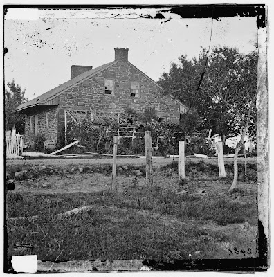
At 1:57, Garry then goes to a place marker for the Dustman property on my map and begins to go into hysterics as he claims I have put the Dustman house itself too close to the road. If he would be honest, he'd see that I had outlined the Thompson House in red, but made no effort to do so on the Dustman House, choosing only to tag the property line which divides the two, with a black line. It was never an effort to define the Dustman House itself. See for yourself, below. It's a place-marker. He knows I know where the Dustman house was, he and I discussed it briefly when I questioned him about finding its foundation when the restaurant was torn down. I might, if I was to be a real jerk, ask him why it was placed downhill on a CWT fundraising map, back when the restoration project was getting under way. But I won't. After all, he was in charge of the project.
Here, below, is a version I did in 2015, with both Thompson and Dustman outlined in red, just for information sake. I was always under the impression that a portion of the original Dustman foundation was integrated into the east entrance of the restaurant, but Garry said the archaeologists found nothing. Interesting. But I digress...
But here he is below, anyway, taking delight at claiming I'm incorrect, at 2:01. He continues to make up things that he wants you to believe I would say to "excuse" this, but if, again, he was honest, and had actually read all my material instead of selective interpretation on his part, he would know that I in fact have made it quite clear that the Dustman House IS ALSO IN THE PICTURE!!! But, he's too busy trying to claim I am an ignorant fool. Here is the link to my posting of October 1, 2015 that provides overlay images in a video, where I toggle back and forth, mentioning the location of Dustman on top of the restaurant. Watch it. Apparently Garry did not, or perhaps, forgot. Still he goes on to claim these assertions of his, are a "hallmark" of what I do. He's claiming I find excuses for things he asserts are problematic with my material. Far from it.
Now, at 2:39, Garry claims he has something that I have "chosen not to address", and he goes on to talk about the location of trees, and their leaves, "crawling all over" the Thompson House. He states they are "clearly on the north side" of the road. He goes on to claim that these branches, "touching the Thompson House", must be visible in all other views. Here is the problem though with what he asserts. The branch he points to, "touching" the house, is an orchard tree on the south side of the road. Let's look.
Here's the crop. Is the tree on the north side "crawling all over the house? It looks to me that the tree in the orchard, on the south side of the road, is the one that appears to touch the house, or "crawling", as Garry described it. Click on any of these images for larger viewing.

 Now, below, is an additional image, taken the same day as the above image, looking from a more eastward camera position, about 33 yards or so, east of the previous, without the branches touching. But that's not all. Garry also claims those trees are on the south side of the road after claiming they are on the north side, as he says, they are "below" the ridge. Fact is, the Gardner image shows trees on both sides of the road, orchard trees on the south, and much larger trees on the north side, layered over each other, giving an impression of one massive tree. But, that doesn't play well with his attack on me.  
But Garry goes on from there to say that in my camera position, roughly 430 some yards to the southwest, mostly west, across from the Reynolds monument, my camera angle (according to Garry) is so divergent from the Brady camera angle, that the branches (again!) would be "even more" touching and over hanging the Thompson House. Plus, he asserts my (Gardner's) camera position would show the Thompson House at an increased angle, thus throwing off my use of image comparison with Brady's. Below, I provide a map to illustrate that the two photographer's camera angles are virtually the same. I turned the orientation of the map to replicate the Gardner field of view as if seen straight on. The map compass is there, so don't freak out, you can still see where north is. I marked Brady's position with a "B", across from Thompson, outlined in bright red, and Gardner with a "G", toward the bottom of the view, Note Gardner's right angle of view, in yellow, follows all the way up to the Brady position. Does not look too divergent to me. One point I'm not even going to dignify is his assertion regarding the north chimney on the Thompson house. It is there, blending into the roof line, but I'll let him figure that out. One has to remember, Garry insists that individual fence posts should be visible, despite the effects of aerial perspective. He has demanded elements of clarity should exist while ignoring the reality that this image suffers from pronounced atmospheric issues on the horizon line. Repeatedly I have explained all the elements he questions in those regards and he ignores them. And yes, broad areas of light and dark do present correlation of these shapes, thus a white picket fence can appear as a distinct area of white, without having to show individual pickets. 
Be sure to click on these images for larger viewing.
From there, Garry goes on the claim I ignore trees that were standing in the Gardner view, yet those mid ground trees are a prominent feature in my work, as they stand along a fence line that cuts across the Gardner images at a slight diagonal, and are discussed repeatedly throughout my numerous presentations. Once more, for ease sake, here is the link I shared earlier, and in it the discussion of those trees, and fence, are a main point of discussion.
But, and here is the clincher, on November 4, 2015, I posted stereoscopic comparisons, with the period image and a modern views, demonstrating how the terrain is identical. But Garry makes no mention of that, at least as of this writing. Here is the link.

Finally (hardly!), Garry begins to throw in things to characterize, he says, my explaining away or making excuses for things, even throwing in a wild remark about the Thompson House moving, as though I've ever suggested that. He is trying to paint me as crazy. And just when one would think he is running out of gas, he begins to attack my other assertions, that the other view, the actual "Harvest of Death" images, have been modified, in both the full plate and stereo, when I have, in other postings, made it quite clear they were, in Gardner's effort to make a poignant best seller. I have even gone to the source, the Library of Congress, and provided evidence of masking on the actual stereo glass negative. The full plate image, especially the Chrysler Collection print, provides clear evidence of modification. That modification has been pointed out in a series of progressive alterations which ultimately ended with the iconic "Harvest of Death" view, which captured the hearts of viewers for a century and a half. With manipulated features! Here are the links to both stereo and plate examinations. 
and

OK, finally, you'll see, as Garry nears completion of his six minute video, he begins to get very insulting and mocking of me, trying to give the viewer the general impression that this is what I have been doing, for over five years mind you. He likens me to the character Vizzini, in the movie, Princess Bride. How sweet. And with that he proclaims, "You have the wrong site."

If you haven't had enough of this, be sure to see Garry's video #33 at the end of his Gettysburg Daily post. He plays with a wooden house and grass, trying to further explain the "touching" and "crawling tree" concept.

Really fun.