See the more current post above that removes the doubt expressed here. The woman in both images is Susan M. Alsop, more famously known as "The Widow Susan Alsop".
Second update: An Anonymous comment to this post, added 12/4/2011, points out the widow Alsop's obituary in the Daily Star, December 6, 1915. That obit clearly states that she died "peacefully at the residence of Mr. S.R. Alrich". This may indeed be a clue as to the connection with the Alrich family. That clue had remained embarassingly unobserved by your blog host until this anonymous tip. An immediate assumption would make this "Mrs. S. R. Alrich" to be Annie, the wife of Samuel Alrich, but his middle intitial was "W" according to census records. Those fine details remain still uncertain, but there is now a good indication that Susan M. Alsop was at least a friend of the Alrich family, possibly considered an "Aunt", as many times older friends of a family are called "Aunt" or "Uncle" by children even if there is no blood or marriage connection. We shall persevere.
After a good deal of consideration, I am more and more suspecting that the image from the previous post, despite many people's hopes, is not THE Susan Alsop. My major concern continues to be how it would have become part of the Alrich family collection of memorabilia. So far there is no readily apparent family connection. With many factors to bear in mind, this photograph may actually be of Susan Jane Beazley Alsop, from the other side of the battlefield. This would account for the 1850's clothing more easily than it being Susan M. Alsop.
More if and when we can determine something.
Tuesday, May 31, 2011

Tuesday, April 5, 2011
Is This The Widow Susan Alsop? A treasure from the attic.
When retired museum professional Terry Dougherty entered the attic of the Alrich house near Spotsylvania Courthouse, he knew he had stumbled upon a goldmine of Spotsylvania genealogical material. Last summer, Dougherty paid a visit to the house and Alrich descendant John Alrich-Altman. The majority of the home's contents had been sold off in an estate auction in June, but the attic had remained untouched and as it turned out, packed with an archive of historical images and memorabilia of the family. Many of the items are now on temporary loan to Spotsylvania County for a museum exhibit being prepared by Dougherty as a volunteer to the County. It is a Herculean effort, but one that Dougherty relishes. The display is scheduled to open in late May of this year in the Courthouse Village government office building.
Perhaps one of the most intriguing finds was a photograph with the inscription, "Sue Alsop, Old Aunt, a lovely Christian woman". Immediate speculation is that this is a photograph of the matron of the Alsop Farm of the May 19, 1864 battle fame. Susan M. Alsop was only twenty-one in December 1860 when her husband James Addison Alsop died from the effects of a carriage accident. Susan and her six month old son, John, continued to live on their Spotsylvania farm, witnessing the horrors of battle virtually on the threshold. Susan lived out her days there until she passed in 1915. This copy of the photograph may in fact have been made as a memorial keepsake for family members in 1915 as it is an enlargement of the 1860s period original, mounted on a "cabinet card stock", typically done after the turn of the century for such purposes.


Perhaps one of the most intriguing finds was a photograph with the inscription, "Sue Alsop, Old Aunt, a lovely Christian woman". Immediate speculation is that this is a photograph of the matron of the Alsop Farm of the May 19, 1864 battle fame. Susan M. Alsop was only twenty-one in December 1860 when her husband James Addison Alsop died from the effects of a carriage accident. Susan and her six month old son, John, continued to live on their Spotsylvania farm, witnessing the horrors of battle virtually on the threshold. Susan lived out her days there until she passed in 1915. This copy of the photograph may in fact have been made as a memorial keepsake for family members in 1915 as it is an enlargement of the 1860s period original, mounted on a "cabinet card stock", typically done after the turn of the century for such purposes.

The image of "Sue Alsop", enhanced and restored from a
scan of the original by John F. Cummings.
The inscription on the back is shown below.

The interesting features of the photograph are the trappings of mourning etiquette that the woman is wearing, which taken by themselves are supportive of this being the "Widow Alsop". She is wearing a photo broach of her deceased husband, pinned to her collar, a tradition of Victorian era mourning practices. Considering that the collar is white, this indicates that the photograph would have been made after the end of "Full Mourning", which was to last for a year and one day. In full mourning the widow was required to wear all black for the entire period. After entering second stage mourning, a widow could add some color to her clothing, usual a white collar and cuffs. This being second stage mourning would indicate that it was taken no earlier than late December of 1861. Considering the distance to photographers in Fredericksburg from her Spotsylvania home, it is even likely that the photograph was made in early 1862 with the arrival of weather conditions more hospitable to travel on country roads.
It should be noted that the hairstyle this woman is wearing is typically that of the 1850s era, a style consisting of padded wings over the ears. If this is indeed THE Susan Alsop, widow of James Addison Alsop, one has to consider that she is wearing a hairstyle that would have been out of vogue by the early 1860s. This does not mean that she could not have opted to continue this style, but typically a young woman as she was then, approaching 23, would have been more inclined to keep up with fashion of the day.
Further scrutiny will be required of this and the hundreds of other images found in the Alrich attic. We are fortunate that they have survived to provide a window into the county's past.

The south western exposure of the Alrich home,
(Dabney house during the Civil War), and the lone attic window.
Photographed June 5, 2010 by John F. Cummings.
Sunday, April 3, 2011
Stafford Post of April 2: Technical issue with images is fixed.
For some reason, the images in yesterday's post on the Review Site in Stafford County were displaying square, thus they looked compressed. I have corrected the problem and they should be easier to look at on the blog page now. They are still clickable for enlarged viewing.
Thank you for visiting the Spotsylvania Civil War Blog.
Thank you for visiting the Spotsylvania Civil War Blog.
Saturday, April 2, 2011
A Look at Lincoln's April 8, 1863 Review of the Troops in Stafford County: By Request
In January and early February, NPS historian Noel Harrison made two in depth posts at Mysteries and Conundrums, the first here, and the later one here. Noel and I exchanged thoughts regarding the location of the sketch by newspaper artist Alfred Waud, seen below. Please read the articles over at Mysteries and Conundrums to get the whole gist of this discussion. In February, Noel graciously asked if I would post more details on my thought process of interpretation via the Spotsylvania Blog, so now, after many other distractions have been dealt with, I will now provide my thoughts on what I believe we are seeing in this image. First, I have to point out that I hold Alfred Waud in high regard as an artist and firmly stand by his abilities to translate what he saw to paper, especially with regard to landscapes as will be the strongest part of my argument here.
At this point, to avoid repetition, I will simply use the images below to provide my premise. The first image is the original Waud sketch. Please click on any image presented here for larger viewing.


Waud's sketch had to have been drawn from an elevation such as a signal tower near headquarters. Waud was not in the habit of presenting false, elevated views such as those Edwin Forbes was inclined to do in his work.
The sheer number of troops involved in this presentation would have required them to be formed by Divisions, in columns of Brigades. If they had been formed with an entire Division front, each front would have stretched about a mile in length based on mid war regimental strengths. A mile long line could not have moved in a graceful parade formation with any ease, as was described and praised in accounts of this review for the President.

Relative placement of modern roads against Waud sketch.


Satellite image indicating roads and landmarks relative to Waud sketch. The blue lines seen along Deacon Road demonstrate the Divisions formed by columns of Brigades. A newspaper account describes the area as having been cleared of most trees for the occasion as well as the bridging of water obstacles. This facilitated the fluid movement of the large masses of troops. The Review could not have been conducted in a smaller area than what is presented here. These observations are important toward the historical understanding of the site, otherwise lost within the residential development that has covered the once larger tracts.
Please do enlarge this one so that the annotations are legible.


View across the modern neighborhood from the yellow X indicated above.


Closer view of hill at left from which the Lincoln entourage watched the
review, as indicated in the satellite image by the green X.

Thursday, March 24, 2011
Placing Some of the Dead at Widow Alsop's
Note: All images can be clicked for larger viewing.
Certainly, any battlefield photograph that shows the dead in situ has intrigued the public ever since Mathew Brady first displayed images of the dead of Antietam at his New York gallery in October 1862.
The May 20, 1864 images of Confederate dead on the Susan Alsop farm in Spotsylvania are a prime example, and have been most engrossing. For the twelve years I have lived near the site, and have studied Timothy O'Sullivan's series, I have been hopeful that I could make some solid determination as to where at least some of the images were made. The first obstacle in doing so was the uncertainty as to the precise location of the Alsop farmhouse. National Park Service Historian Noel Harrison and I have pondered this over the years and together have become fairly comfortable with an approximate location. Only one image in the series had clearly specified that it showed the house and a small barn/stable, nearby. Using the official government map produced in 1867 by Nathanial Michler, I compared the terrain features depicted and found what seems to be the most logical match against a modern topographic map. Working with the Michler map, one has to be aware of the potential for distortions which occur when an individual surveyor's notes are married to a fellow surveyor's set. As an illustration, sometimes a farm field would be included by both men in their individual surveys, and instead of overlapping, the area is mistakenly plotted twice on the compiled map. One area of clear distortion is unfortunately within the sector of the Alsop and neighboring Peyton farms, making a simple overlaying of period and modern maps impossible. Fortunately, once the pattern of the distortion is recognized, one can compensate for the problem and adjust as needed. This has allowed for a reasonable placement of the house upon the modern landscape, one which we will examine later in this post.

Another image in the series, taken prior to the one above, depicts two of the Confederate dead nearby on the property. The soldier immediately behind the pile of fence rails is clearly the same body as the one on the stretcher as was indicated by William Frassanito in his 1983 book, Grant and Lee, The Virginia Campaigns, 1864-1865.
A long overlooked yet vital clue as to the relationship of this image and the one of the Alsop house, is seen in the upper right of the horizon line. There, though not in sharp focus, appears to be the west exposure of the Alsop house, along with the surrounding trees that are readily discernible from the full house image.

An enlarged detail of that portion of the photograph shows the
open window at right, and the surrounding trees of the home's western
face, making this approximately 80 yards to the east of these bodies.

In the detail below, note the window and row of fanlike trees within the
fence, as well as the larger trees inside the field. The tree on the left edge
below is the tree at right of center in the above detail.

Below is my hypothetical interpretation of these images placed on the landscape.
The tree line to the north of the property is most likely where the original
image caption, "Scene at Mrs. Allsop's Pine Forest", was derived. When
viewed in stereo, there appears to be a sunken lane between the fence and
the woods, but I have opted to leave this possible feature out of my drawing.

Based on this hypothesis, here are "then and now" comparisons.
Set One: Looking East From "A"


Set Two: Looking North East From "B"


Over at the F&SNMP's "unofficial" blog Mysteries and Conundrums, Chief Historian John Hennessy has recently weighed in on his interpretation of the Alsop Farm images. You can read that here, at this link.
A satellite image of the area involved as it looked in 2009.
Note: The roads seen in this view are modern driveways with no historical significance,
and have no correlation with the farm lanes I have indicated in my diagram.

BE AWARE: all of this property is privately owned.
Please respect the owner's right to privacy.
Tuesday, March 1, 2011
Building the Spotsylvania Exhibit Shelter: Mission 66 - A Then & Now Look
In preparation for the fiftieth anniversary of the National Park Service in 1966, the Department of the Interior implemented a ten-year program of enhancement projects designed to improve the visitor experience. The program was dubbed "Mission 66." Among these tasks were the construction of modern interpretive facilities, replacing the rustic Contact Stations of the CCC era. In the Fredericksburg & Spotsylvania National Military Park, two new Visitor Centers and three Exhibit Shelters would be constructed to coincide with the anniversaries of the battles they'd interpret. The Chancellorsville Visitor Center was set to open on the first weekend in May, 1963. By July of that year, construction was underway for an exhibit shelter on the Grant Drive entrance to the Spotsylvania unit. By the end of April, 1964, the shelter was nearing completion, in plenty of time for the hundredth anniversary of the Spring Campaign of 1864.
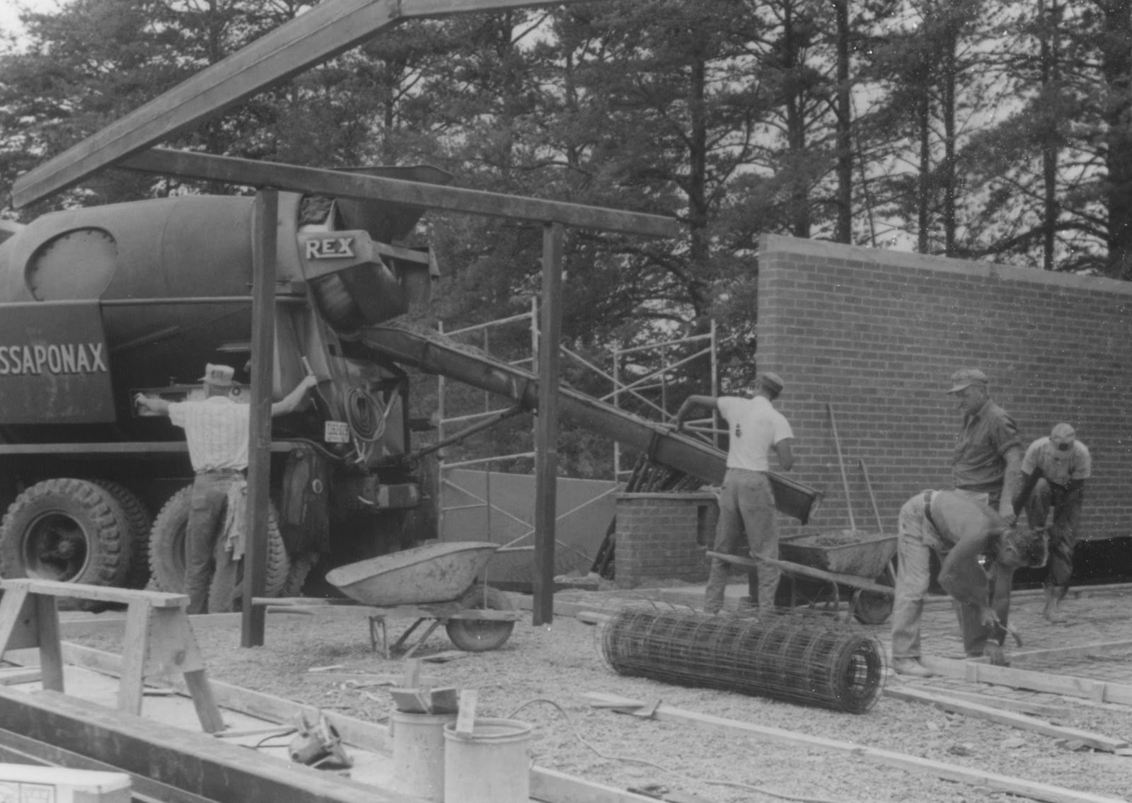
This September 1963 photograph documents the pouring of the concrete floor and patio of the Spotsylvania Shelter. It was built on a substantial cinder block foundation with brick walls and a heavy steel framework that emulated residential architecture of the day. The roof had four skylights to provide additional ambient light to the open air design.

Approximate same view in February 2011.

Prior to the installation of wire mesh to the open gable ends of the rafter
system, workers are seen here applying a clear sealer coating to the
natural wood ceiling planks inside the interpretive area.

Over time, the natural wood look was replaced by a heavy coating of
white paint, providing durability and easier maintainance. Note the
skylight and wire mesh enclosed gable end.


and more engaging graphics installed around 2004. There is a continuing
effort to enhance the visitor experience. Photo taken February 22, 2011.

Peder Kitti and Frank Philips of the Department of the Interior's Branch
of Museums, prepare hardware for the mounting of the interpretive panels.
They were assisted by Freddie Paytes of the F&SNMP maintenance department.
Note the accordian style, gate enclosure for the shelter, rarely if ever, used today.

Approximate same view, February 2011.
The one-hundredth anniversary of the National Park Service will be celebrated in 2016.
Black and white photographs seen here are from the files of the F&SNMP.
Color photographs copyright 2011 by John F. Cummings III
Monday, February 21, 2011
Earthwork Preservation and Protection: Lessons of the past in consideration of the future.

The Civil War Roundtable of Franklin, Virginia , on November 12, 1957, stand posed directly on the Bloody Angle, at the point where the Union line is conjoined with the Confederate parapet. To the left of the group is NPS historian, Ralph Happel, who had served as their guide at the adjacent contact station, not visible in this image. The view is looking east, along the face of the Salient. Note the large cedar tree looming immediately to their backs at right. This photograph is from the archives of the F&SNMP.
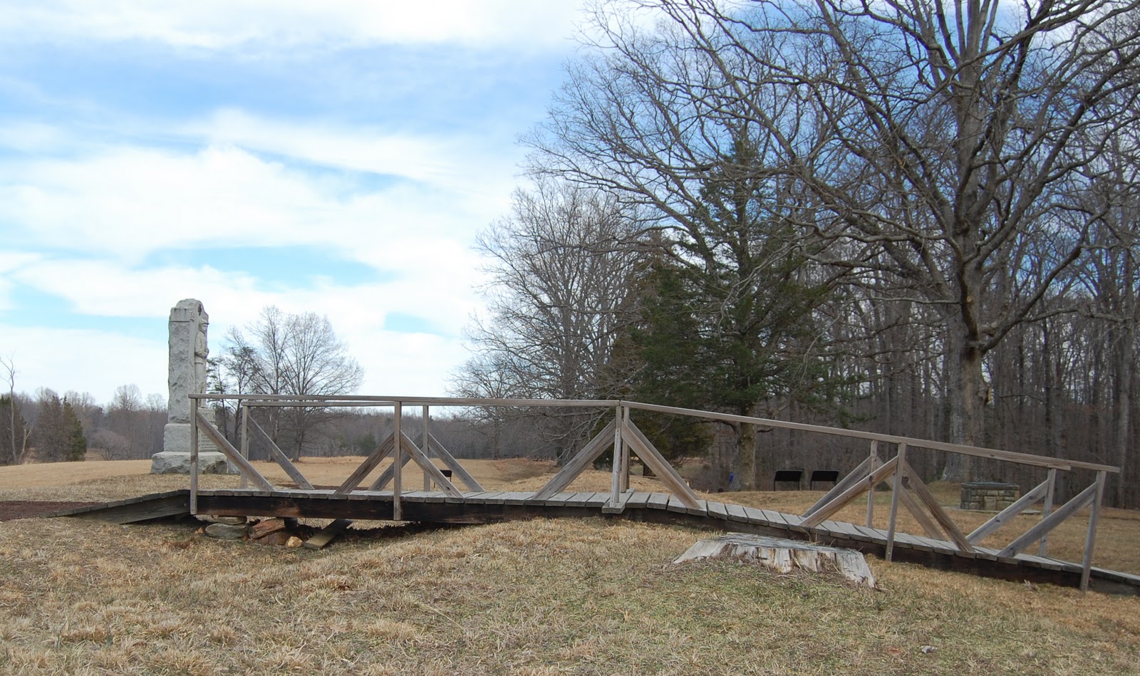
The same spot, fifty-four years later. The Bloody Angle is protected from most intrusive pedestrian incursions by virtue of this wooden bridge, due to be removed at some point in the very near future. Previous posts on this blog, here, here, and here, have covered the construction of a new bridge futher down the line. Note the stump of the large cedar tree at right middle, immediately to this side of the bridge. The cedar was removed a few years ago to help restore the unobscured vista of the Bloody Angle, to that which the soldiers would have experienced. The cedar tree had been planted in the early days of the park as an ill-conceived landscaping measure, one of the conflicts of "battlefield park" versus "natural park" philosophies.

Sparingly placed, so as to to be themselves non intrusive, signs such as these are designed to instill a discipline within the visitor to be mindful of the resource's delicate condition. Sadly, this does escape the consciousness of many, and on a daily basis a casual observer will witness numerous, shocking examples.
The question for the future must now be, "Will the park visitor dutifully follow the new trail system, or will they feel unflinchingly compelled to veer from the path and walk on the earthworks?" The future will tell.
Tuesday, February 8, 2011
23rd USCT Re-forming for Sesquicentennial Commemorations in Spotsylvania

Gathering for the organizational meeting of the 23rd USCT
are left to right: Rev. Hashmel Turner, Col. Horace McCaskill Jr. USA, (Ret),
Steward Henderson, Roger Braxton, and John F. Cummings III
Over the past decade there has been some intense interest focused on the Spotsylvania experience of the 23rd United States Colored Troops, a regiment comprised of former slaves, many from the County and surrounding area. Prior to May 15, 1864, USCT's attached to the Army of the Potomac were routinely assigned to non combat roles, primarily guarding supply wagon trains. Organised at Camp Casey, near the modern day site of the Pentagon in Arlington, Virginia, the 23rd was assigned to the 4th Division of the 9th Corps, led by Brigadier General Edward Ferrero, a well known dance instructor in pre-war civilian life.
On the morning of May 15, Confederate cavalry was probing along the back roads far north of the prior week's concentration of fighting. Their goal was to harass Union hospital sites and supply lines, with the intent of liberating as much as they could with minimal casualties. Riding hard along the Catharpin Road towards the Old Plank Road intersection, the southern horsemen came upon the 2nd Ohio Cavalry Regiment who were resting near Piney Branch Church. Panicked and outnumbered, the Ohio troopers took off pell-mell toward the Alrich farm, a good mile and a third away. From there some of the terror stricken Union horsemen proceeded north to alert the closest possible reinforcements. Near the Chancellor House ruins, the 23rd USCT, sprang to the call and proceeding south, encountered the approaching Confederates in what would be their very first exchange of fire with the Army of Northern Virginia. The southerners fell back, suddenly outnumbered, with the 23rd holding the intersection.
This historic encounter has until recently gone unappreciated as a major landmark on the road to the end of slavery in America. However, plans are now in development to commemorate this contest by placing an interpretive marker near the place the Ohio troops were first surprised. The intersection where the 23rd USCT actually fired upon the Confederate Cavalry has been deemed too dangerous to place a safe pulloff area.
In anticipation of the opportunities during the Sesquicentennial to tell the story of the 23rd, I began to talk with friend Steward Henderson about assembling a representative unit as re-enactors. Thus far there has been substantial interest in making such a portrayal available over the next four years. Additional interest has been expressed by the John J. Wright Educational & Cultural Center Museum who will partner with us in our efforts
National Park Service Historian, Eric Mink, has spent numerous hours delving into the service and pension files of Spotsylvania men who had served in the 23rd USCT. His work has been invaluable toward assembling the story of these men's lives. Some of his findings have been posted on another blog, here and here.
National Park Service Historian, Noel Harrison has also written a blog posting here, detailing the location of the skirmish and the encounter that brought it about.

Brigadier General Ferrero is seated at lower left with members of his staff,
near Petersburg, Virginia in the summer of 1864. An armed sentry, possibly a
member of the 23rd, stands at his post to the right of the white officers.

Monday, February 7, 2011
Manassas - Another Project nears completion
Those who know me are aware that I have been working several book projects in tandem. One regarding local photography is close to seven years in the mix. However, in the next few weeks, I anticipate sending another finished manuscript to the publisher, this time focusing on the Manassas Battlefields.
Before moving to Spotsylvania, I lived in Northern Virginia, in Fairfax County, for thirty-nine years. Growing up within ten miles of Manassas/Bull Run, enabled me to nurture my early interest in Civil War history, and I visited the battlefield there countless times, both as a child with my parents and even more frequently as a young adult. There has always been something strangely alluring about the Manassas Battlefield for me, something incorporeal. Logically, all the battlefields should manifest these same conditions, but with every return trip I make to the "Plains of Manassas", I am reinforced with these strange emotions.
My Manassas project is heavily built on "then & now" comparrison photographs. Oftentimes in doing this comparrison work, one finds the landscape has changed over a century and half to such an extent that true side by side alignment is difficult to impossible, particularly when the subject matter sits within a wooded area.
Last week (February 2), I took the opportunity to revisit one last time before finishing, an area that normally is obscurred by heavy foliage within trees. My goal there was to use a recent snow fall to provide a better ground contrast against the trees and background sky. I was delighted with the results since prior attempts were at other times of the year, and failed to show the terrain features needed for a true "then & now" match up.
The black and white image below is the original wartime photograph taken in March 1862, showing two boys knealing in front of a row of water logged soldier burials. The site is on a small, flat, bottom area in front of the west face of the ridge that Sudley Church sits on. The church can be seen through the trees at upper left. After the Battle of First Bull Run, in July 1861, this area was used for a field hospital, along with the church building. As is typical in such situations, soldiers who did not survive the ordeal were buried hastily in shallow graves nearby.
Although the church building has been rebuilt since the Civil War, my modern, color photograph demonstrates the surrounding landscape has retained the same characteristics it displayed in 1862, especially the thin trees, albiet now entangled in thorny undergrowth. Fortunately, the property is still owned by the church and one can not anticipate an encroachment to destroy this hallowed ground.
My goal is to have this book in print by July, in time for the 150th Anniversary of First Manassas.


Before moving to Spotsylvania, I lived in Northern Virginia, in Fairfax County, for thirty-nine years. Growing up within ten miles of Manassas/Bull Run, enabled me to nurture my early interest in Civil War history, and I visited the battlefield there countless times, both as a child with my parents and even more frequently as a young adult. There has always been something strangely alluring about the Manassas Battlefield for me, something incorporeal. Logically, all the battlefields should manifest these same conditions, but with every return trip I make to the "Plains of Manassas", I am reinforced with these strange emotions.
My Manassas project is heavily built on "then & now" comparrison photographs. Oftentimes in doing this comparrison work, one finds the landscape has changed over a century and half to such an extent that true side by side alignment is difficult to impossible, particularly when the subject matter sits within a wooded area.
Last week (February 2), I took the opportunity to revisit one last time before finishing, an area that normally is obscurred by heavy foliage within trees. My goal there was to use a recent snow fall to provide a better ground contrast against the trees and background sky. I was delighted with the results since prior attempts were at other times of the year, and failed to show the terrain features needed for a true "then & now" match up.
The black and white image below is the original wartime photograph taken in March 1862, showing two boys knealing in front of a row of water logged soldier burials. The site is on a small, flat, bottom area in front of the west face of the ridge that Sudley Church sits on. The church can be seen through the trees at upper left. After the Battle of First Bull Run, in July 1861, this area was used for a field hospital, along with the church building. As is typical in such situations, soldiers who did not survive the ordeal were buried hastily in shallow graves nearby.
Although the church building has been rebuilt since the Civil War, my modern, color photograph demonstrates the surrounding landscape has retained the same characteristics it displayed in 1862, especially the thin trees, albiet now entangled in thorny undergrowth. Fortunately, the property is still owned by the church and one can not anticipate an encroachment to destroy this hallowed ground.
My goal is to have this book in print by July, in time for the 150th Anniversary of First Manassas.

March 1862, by George N. Barnard

February 2011, by John F. Cummings III
Official Virginia Civil War Sesquicentennial Vodcast
Much of the dramatic footage seen in the above video is compiled from the combined talents of John Hennessy, Chief Historian of the Fredericksburg and Spotsylvania National Military Park, and Media Magic Productions of Lansing, Michigan. The material was shot over several years locally, with many extras culled from the community, to produce three documentary films exhibited and sold at the Battlefield Park, Fredericksburg, Chancellorsville and Virginians Desolate, Virginians Free. John Hennessy wrote the script for the films and provided on-site consultation during the filming and post-production. A fourth film, on the Wilderness and Spotsylvania is in the formative stages.
John has also played a significant role in orchestrating the regional preparations for the Civil War Sesquicentennial. An indefatigable worker, possessed by an indomitable spirit, John personifies the term "multitasking". We can expect many great things over the next four years from John and the entire staff of the F&SNMP.

John Hennessy is seen above, lecturing on the local civilian experience
during the Civil War, at the 145th Anniversary Re-enactment
of the Battle of Chancellorsville, May 2008. Photo by Julie Bell.
Subscribe to:
Posts (Atom)