Battlefield Guide Services

Wednesday, May 14, 2014

The Destruction of the Myer Farm, and the Death of a New Jersey Colonel at Spotsylvania

     The farm of John Henry Myer had been a bucolic delight, occupying a prominent rise above the Ni River valley, and scarcely a mile and a half east of Spotsylvania Courthouse.
     The Myer family had purchased the land in late April 1863, and the distance it provided from the horrors of war ravaged downtown Fredericksburg had been a major consideration in the transaction. John Myer, the father, had emigrated from the Kingdom of Hannover in 1846, making Fredericksburg the home for his growing family and the location of his prospering bakery enterprises on William Street, backing onto Market Square. Agriculturally, Myer was looking to transition the fields to wheat which would provide his own flour. The previous owner, Mordicai Gayle, had concentrated on tobacco, as many of the surrounding Spotsylvania farms had done.
John Henry Myer before the war, as a young entrepreneur.

     Just a year after their exodus, John Myer was conscripted into the Confederate service, and as if by fate, the war he was entering came virtually to the doorstep of his home. Positioned in a landmark earthwork known today as Heth’s Salient, the 40th Virginia Infantry were just two miles west of his farm, and on May 15, 1864, billows of black smoke ominously filled the sky above the idyllic homestead. The Union Army was burning his property in a retaliatory move caused the previous day by the rash actions of an entrusted tenant, Thomas Jett. Jett had introduced himself to the occupying Union forces on the morning of May 14, 1864 as noted in the Official Records. When the tide shifted later that afternoon, and overwhelming Confederate numbers took the ground back, Jett brashly fired upon the retreating blue coats with his personal weapon, but the Confederate victory was short lived, and the Union retook the hill with relative ease as the evening came on. Daniel M. Holt, the Surgeon of the 121st New York, reflected in his diary entry of May15th, "Again upon the ground lost yesterday. Our Brigade in front as skirmishers. Remain all day. The most quiet one of the campaign, so far. No picket or other firing heard. Encamp for the night in a log cabin, the last of Negro quarters. We burned the large house and outbuildings because the owner was a rebel and upon our evacuating yesterday, fired into our "demoralized" ranks. It was a good building and its destruction helped to pay for that shot."
Of course it was not Mr. Myer, the true owner of the house, who fired that shot, and thus he would unwittingly suffer for the misdeed of a man he entrusted as caretaker while he was away, fighting in a war he wanted no part of.
     Further exacerbating the Union force’s ire against the Myer property was the death of Lieutenant Colonel Charles Wiebecke of the 2nd New Jersey Infantry. Wiebecke and his men had been thrust into the action of May 14th almost as an afterthought, providing a modest bolstering of the defensive line that afternoon. Sent forward as support for skirmishers examining a suspected Confederate advance, the Jersey men ended up taking the solid brunt of the attack when the suspicion proved all too real. The regimental chaplain for the 2nd later described the incident, “Suddenly, the enemy advanced in overwhelming force, and the Union skirmish line fell back thro’ its supports, thus leaving Colonel W with his men in front. Their well directed fire broke the rebels’ first line. But other lines of battle continued to advance. At this moment, Col. W. raised himself from behind the protection of a few rails, whence his men were firing, to reconnoiter the advancing foe. While so doing, he was struck by a bullet, which entered at the right eye, penetrated to his brain, causing instant death.” The Colonel’s body was left in Confederate hands for several hours before the Union retook the hill, and in that interim, the chaplain explains to Wiebecke’s widow, “…the barbarous foe had plundered your husband’s body of his watch, his money, and most of his clothing.”
    This maltreatment of the body inflamed the men of the rank and file, and by dawn of the next day much of the personal property was wrecked prior to being set to the torch. 
Lt. Colonel Charles Wiebecke of the 2nd New Jersey
from a reunion ribbon in the author's collection.
Your blog host portrayed Wiebecke in a documentary film in 2004.
Photograph by Robert Szabo.

     On May 22, 1864, seven days after his Spotsylvania home was destroyed, John Henry Myer was captured near the North Anna River and spent the rest of 1864 as a POW at Point Lookout, Maryland. He took the oath of allegiance on December 15 and returned home to Fredericksburg. In 1866 he sold his decimated Spotsylvania farm at a considerable loss, but went on in the postwar years to become one of Fredericksburg’s most successful business men and community leaders.

     Today the property sits begging for attention. The woods surrounding the house site were logged in recent years, damaging sections of delicate earthworks that remained from Union occupation. Much of the land is covered in heavy secondary growth.
NOTICE: THIS PROPERTY IS POSTED.  TRESPASSERS WILL BE PROSECUTED.

Myer's Hill, Spotsylvania - Only Known Period Image - Dated May 10, 1864

     Today marks the 150th anniversary of an engagement that resides in the category of great "what ifs". In the early morning hours of May 14, 1864, General Grant was about to face another frustration in his efforts to strike down Lee's Army of Northern Virginia. An intended stealth maneuver of the Federal 5th and 6th Corps had literally bogged down in the mud of Spotsylvania County during a night march. The plan was to extend the Federal left and strike at the Confederate right, weakly held near the Courthouse. A scheduled 4 A.M. attack down the Courthouse Road would be an impossibility. At 6:00 A.M., Meade communicated the disappointing news to the General-in-Chief, "Warren reports the head of his column just arrived. The column broken and scattered. He doubts the practicability of getting his command into a condition to do anything today. General Wright has also just reached here, and I have directed him to move over to the Massaponax Church road and mass out of sight of the enemy." 
     A slow, but steady trickle of Union men continued to make its way down the road, and they extended their left across the fields of the Gayle and Beverly farms, the latter being on the south side of the Ni River. In the overcast morning light, Confederates on a slight rise, a mile southeast of Beverly, observed the movement of Warren's men. The southern force consisted of a portion of Chambliss' Cavalry Brigade, supported by McGregor's Battery of Horse Artillery. The property they occupied was known alternately by several names, Bleak Hill, Gayle, Galt, and most correctly for the time, Myer's Hill. The Myer family had acquired it the year before, just as the Chancellorsville Campaign was erupting nine miles to the northwest. The paterfamilias, John Henry Myer, on this morning was stuck in Heth's Salient along with the 40th Virginia Infantry, into which he had been recently conscripted.
     To simplify for this posting, by the time the sun had set on May 14th, the Myer farm would be contested twice. During the second episode, General Meade came close to being killed inside the Myer House by McGregor's guns as they opened fire around 4 P.M.; and while barely escaping toward a crossing on the Ni, he would almost fall into the hands of a bold Confederate Major who reached out to grab him. 
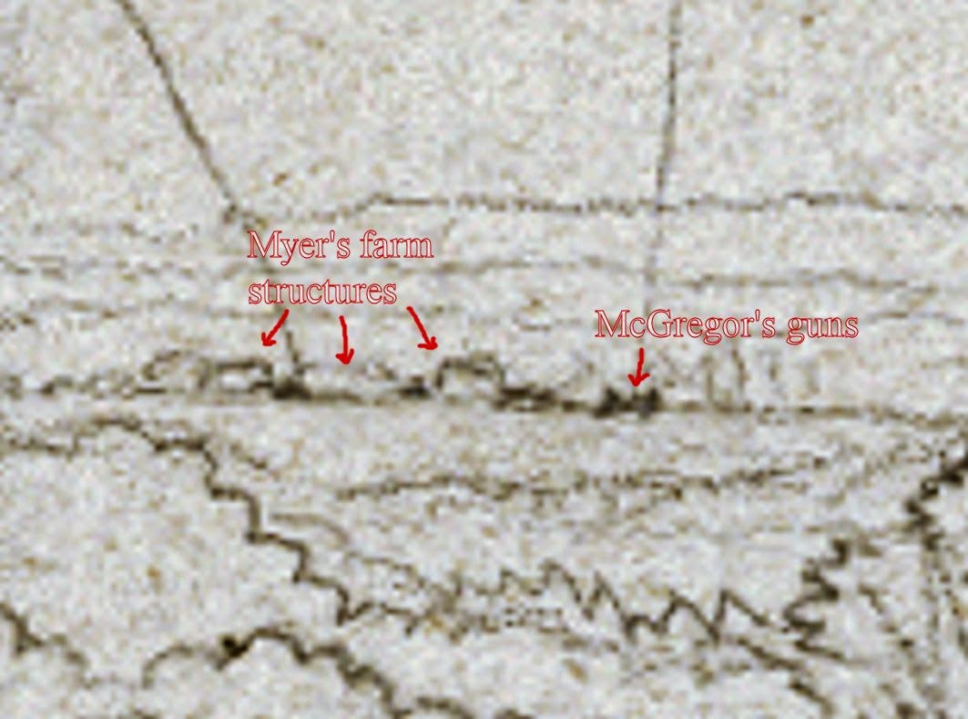
     Four days prior to this action, a special artist for Frank Leslie's Illustrated Newspaper, Joseph Becker, created a two page panoramic sketch of 9th Corps troops advancing down the Courthouse Road, passing over the Gayle farm on the left. In the middle of the scene of the left hand page, the Beverly Fam sits atop a rise beyond Gayle. And, most interestingly, situated on the horizon line, above the Gayle House, is a small annotated detail which depicts the Myer House and surrounding outbuildings. McGregor's guns are identified as "Rebel Bat" to the right of the structures. McGregor and Chambliss had occupied the summit as pickets since the 10th. Click the following images for larger examination.
Detail from the Becker sketch, showing Myer's Hill at left of center horizon line.
Closer detail showing Myer structures and battery. My annotations in red.
The full, left page of Becker's two page panoramic sketch.
Courtesy of the Becker Collection, Boston, MA

Further details of the Becker Collection are available at the following link: http://idesweb.bc.edu/becker/about

Tuesday, May 13, 2014

The Morning After - May 13, 2014 - Where Alfred Waud Sketched, 150 Years Ago Today

     And now it's all over. Thousands of visitors had come and gone for the past ten days. They came to walk the ground hallowed by the blood of two armies, a century and a half after the fact. Many came to honor their own ancestors who fought and died here in Spotsylvania County. Some freely acknowledge their families came to America after the Civil War. It's the strange allure of the conflict, the defining drama of our nation. Others can't define what brought them. But there is a kinship amongst all that came out to see the very ground, and hear the horrific accounts of the vicious struggle. And they ended their pilgrimage on this now quiet field. Quiet for yet another day. For twenty-two hours, starting around 4:30 on May 12, 1864, it was hell on earth. Few who survived that day would write about it. It was that traumatizing. But those that did write their memoirs years later would leave little doubt about the ghastly aftermath. A private of the 95th Pennsylvania Infantry, G. Norton Galloway, described what he witnessed in the early morning of May 13, 1864:  "A momentary gleam of sunshine through the gloom of the sky seemed to add a new horror to the scene. Hundreds of Confederates, dead or dying, lay piled over one another in those pits. The fallen lay three or four feet deep in some places, and, with but few exceptions, they were shot in and about the head. Arms, accouterments, ammunition, cannon, shot and shell, and broken foliage were strewn about. With much labor a detail of Union soldiers buried the dead by simply turning the captured breastworks upon them. Thus had these unfortunate victims unwittingly dug their own graves. The trenches were nearly full of muddy water. It was the most horrible sight I had ever witnessed."

May 13, 2014, 6:34 A.M.
     Above, an embellished sketch by newspaper artist Alfred Waud, was drawn May 13, 1864, when the location was actually free of engaged troops. What Waud would have come upon was a field strewn with bodies of the dead and the associated debris of war. Harper's Weekly's "special artist" was an accomplished landscape artist and he accurately depicts the ground before him. The viewer can click the image and examine more closely the mastery of his craft. Notice that the bodies of the dead are of a slightly larger scale and are placed on the paper in a sketchy, quick hand. The figures of the soldiers doing the fighting are executed with more refinement, filled in after Waud would have returned to a conducive work space. It is also interesting that he included a conference of seemingly unfazed officers in the right foreground. Although Waud, and the other newspaper special artists of the day are characterized as having crawled toward an engagement and sketched a battle as it unfolded, I have no illusion that he would have done so at this hot a location. This sketch was later turned into an engraving and published in the June 11, 1864 issue of Harper's Weekly on pages 376-377.
     On October 11, 2009, I enlisted the assistance of National Park Service historian Eric Mink to confirm the location from which I believed Waud had made his base sketch. I established a static camera position with the camera on a tripod, and then directed Eric to assume various poses in the approximate locations of the figures Waud created from his skilled imagination. In all, Eric kindly repositioned himself sixty-three times across the landscape, including the distant prolongation of the Federal line that created the "Bloody Angle", the area where Waud depicted the heavy billowing of gunsmoke at middle right. As seen above, I then digitally combined all the "Erics" into a finished piece.
     A few years later, a rubberized mulch trail was installed across the position of the kneeling Union soldiers, along with an interpretive sign utilizing Waud's drawing. 


Sunday, May 11, 2014

Death of Major General John Sedgwick - 150th Anniversary, On Location, To the Minute


     National Park Service Historian, Frank O'Reilly, met an appreciable gathering on Friday, May 9th, to commemorate the life, and tragic death, of Union Major General John Sedgwick. Standing in the clearing where Sedgwick played out his final moments, those present were experiencing that drama 150 years later, to the hour, and to the minute. O'Reilly vividly recounted the moments that led up to Sedgwick's famous admonishment of his men, "I am ashamed of you! They couldn't hit an elephant at this distance!"
     The General was struck somewhere around 9:00 A.M., Civil War time, approximately 10:11 A.M. modern time, making adjustments for daylight savings time and railroad time.

     Your blog host filmed this presentation with the camera facing the direction Sedgwick faced, looking toward the open field to the left distance, the location from which the concealed sniper would fire the shot that killed the highest ranking officer on the field of battle during the Civil War.
Click the images below for larger viewing.
   
 Looking southward from behind the monument to Sedgwick, which stands on the spot where he fell. 
 Looking somewhat northeast, with the Park's exhibit shelter at the left distance.
 The monument was dedicated on May 12, 1887.
  Frank O'Reilly, articulating a point at 10:34 A.M., nearing the conclusion of his presentation. 
     At the conclusion of the presentation, Frank O'Reilly and your blog host stand facing the field from which the sniper took aim, demonstrating the sun's illumination on Sedgwick's face before being struck on the cheek, below the left eye, just to the side of the nostril.
     View from the sniper's assumed position, on an elevation roughly 445 yards south of the Sedgwick monument. The monument is just inside the notch at the middle of the woodline, where the Brock Road begins to disappear from view.

Thursday, May 8, 2014

"Literally Shot To Pieces" The Mortal Wounding of Corporal Emerson Rude - May 7, 1864

     Around 3:00 P.M., on Saturday, May 7th, 1864, the men of the 1st New York Dragoons dismounted about a mile south of Todd's Tavern, along the Brock Road. Pressure was being applied to Confederate forces blocking the direct path to Spotsylvania Courthouse. Additional units from Colonel Alfred Gibbs' Reserve Brigade also pressed forward with the Dragoons, at the double quick. A mile ahead of them, rebel cavalry had built a substantial log barricade covering the intersection with Piney Branch Church Road. By the time evening fell, a fierce encounter had ensued with Wickham's Virginia Cavalry Brigade, leaving heavy casualties in the ranks of blue, including Corporal Emerson Rude of Company I, just three days into his 23rd year. In the unit's postwar memoir, an officer recalled the severity of Rude's wounding, describing him as "literally shot to pieces." The wounded were removed from the field by their comrades and taken to the Union Cavalry Corps Hospital in Fredericksburg. Emerson Rude succumed to his wounds on May 10. 
 On October 20, 2012, I accompanied Robert Emerson Rude, at left, to this slight elevation on the Brock Road. He had come to Spotsylvania to witness the ground where his great grand uncle gave his life for his country. We gazed down the quiet corridor, southeast, toward the intersection where the fighting took place, roughly 240 yards beyond where we stood. Cars now freely come and go where once the torrent of war was so horrifically played out. Although a memorial exists for Emerson in the Oakwood Cemetery, in Nunda, New York, all indications suggest he is buried in the Fredericksburg National Cemetery, in an grave listed as "Unknown".
Here is a prewar portrait of Emerson Rude, from his family's collection.

     Aerial map of the intersection of Brock Road and Piney Branch Church Road. The approximate site of the barricade is indicated by the red line. 

     A 1930's photograph of the intersection of Brock and Piney Branch Church Road, looking northwest, from a position behind the location of the Confederate barricade. Photo from collection of the Fredericksburg and Spotsylvania National Military Park.

Monday, May 5, 2014

Spotsylvania 150th, Video Vignette: Rebels "Having An Image Struck"


     In the short video above, we are introduced to members of Bell's Rifle, a unit from Pridgeon's Shenandoah Legion, by Sean Pridgeon. They are just some of the thousands of re-enactors that came out over May 2-4, 2014 to commemorate the 150th anniversary of the battles of the Wilderness and Spotsylvania Courthouse. We see them here on Sunday, May 4, posing for wet plate photographer Robert Szabo, assisted by Ed Mantell.

Click the images below for larger examination.


Saturday, May 3, 2014

150th Anniversary, Wilderness Re-enactment, Video Vignette - May 3, 2014


     Today, whilst on an "embedded journalism" adventure, your blog host met privates Mike Bilder, and Travis Bard from the 26th Pennsylvania Infantry, a unit of the Mifflin Guard. As they explain in this short clip, the Mifflin Guard enjoyed constructing, and sleeping in, a remote defensive position the night before, on the edge of a ravine, overlooking a creek bed. As the viewer can see, their efforts provided an enhanced experience during the 150th anniversary commemoration of the Overland Campaign, being held near Spotsylvania Courthouse, Virginia. The re-enactment continues throughout the weekend.
Click on the images below for larger examination.


Friday, April 25, 2014

Emerging Civil War Authors To Host Weekend Symposium In Spotsylvania, August 15-17, 2014

     With Friends of the Fredericksburg Area Battlefield's change of venue for this years upcoming symposium, the talented stable of authors from Emerging Civil War have partnered with Stevenson Ridge to present the First Annual Emerging Civil War Symposium.

Featured Lecturers and Tour Guides:
  • Daniel T. Davis—”More Desperate Fighting Has Not Been Witness on this Continent.”: Ulysses S. Grant and the Overland Campaign
  • Phillip Greenwalt—From “Old Bald Head” to “Lee’s Bad Old Man”: A Study of the Second Corps, Army of Northern Virginia in 1864
  • Chris Kolakowski—1864: The Last Stand of the Confederate Navy
  • Chris Mackowski—An in-depth tour of the Spotsylvania Court House Battlefield
  • Meg Thompson—A Bad Month for the President: Campaigning the Election of ’64
  • Kristopher White—A tour of the Wilderness and Spotsylvania Court House Battlefields
  • Lee White—”To die like men”: Patrick Cleburne and the Tennessee Campaign of 1864
  • Eric Wittenberg—The Trevilian Station Raid
  • (Also joining us for the Friday roundtable discussion is author David A. Powell and publisher/author Theodore P. Savas.)


  • Stevenson Ridge has a number of packages for symposium participants: a two-night stay for two AND conference registration ($425); a two-night stay for four AND conference registration ($670). Please call Stevenson Ridge at (540) 582-6263 or email info@stevensonridge.com.

Tuesday, April 15, 2014

"Bivouac of the Dead" A Then and Now Examination

     Nearly ten years ago, I set out to find the location of a photograph that had intrigued me for a good many years. The image shows a battle scarred tree, riddled with bullets and set upon by an ax. Nailed to it was a sign board bearing a stanza from the Theodore O'Hara poem, "Bivouac of the Dead". Visitors to our National Cemeteries will recognize the poem, originally written to honor America soldiers killed in the Mexican War. Its stanzas are usually displayed at intervals amongst the rows of stones. To make a long story short, my readers can visit a previous posting containing a podcast of a talk I gave in Charlottesville in March of 2013. Therein you will find more in-depth information on this and other images, taken under the direction of Dr. Reed Brockway Bontecou in April 1866. Additionally, I wrote an article which appeared in the April 2009 issue of Civil War Times Magazine, covering much of the same material. The original glass, stereo negatives had numbers scratched into their emulsion, thus you will see, oddly placed numbers in some prints from the series.
     The purpose for this posting is as a continuation of my study, and obsession, with this collection of images. As seen below, a severely damaged landscape extends beyond the tree. In the left, middle distance, just below the treeline, is the McCoull House, one of the Spotsylvania Battlefield's noted landmarks, unfortunately destroyed by fire in the early twentieth century, but nevertheless, thoroughly photo documented before its demise. Recognizing that structure is what brought about my identification of this site, and the path Bontecou and his entourage took in creating the series. Out of 121 known images taken, only 65 percent survive in print form. None of the original negatives are known to survive today.
     Initially thought to be a piece of board siding from a nearby structure, my examinations determined that the sign was painted on a grave marker, one of undoubtedly thousands supplied by the Quartermaster's Department in the the summer of 1865 to a Union burial party searching the battlefields around Fredericksburg for northern remains. The haste with which both armies exited the region in May 1864, left numerous bodies unburied or in shallow graves. Northern homefront sentiment expressed concern that the recently defeated southerners would desecrate the remains of Union dead, thus an exhaustive effort was made to locate and gather them with legible headboards. Sadly, most would be marked, "Unknown U.S. Soldier". Marking these graves were uniformly prepared boards with arched tops and routed edges. Skilled sign painters were among those performing this task, as evidenced by the precise lettering seen in these photographs and a few surviving originals. It was from one of these relics, on loan to the Fredericksburg and Spotsylvania National Military Park, that I obtained measurements by which I was able to create an exact-size replica of the sign on the tree. Based on these figures, it is also possible to now determine the height at which it was affixed, roughly ten feet, and the diameter of the tree, at approximately 17 inches. Based on documents found in the National Archives, I was able to determine that this image was taken on or about April 13, 1866. Knowing the location and date also allows an approximate exposure time of 8:30 a.m., Civil War time, which is 9:41 modern time, on that date, based on allowances for Daylight Savings Time and the creation of Railway Time in 1883. Shadows, and the amount of sunlight cast on surfaces, functions as a historic sundial, placing a time stamp of sorts on much of Bontecou's journey.

Based on the location and position of the McCoull House, this view looks nearly
due south, across the rear of the Confederate line, behind the Bloody Angle.
Note the sunlight, and shadow created by the tree.
Holding the replica sign, near the location of the original tree, looking south.
Taken at 9:45 a.m., on Sunday, April 13, 2014, 148 years after the original.
A close-up of my replica, near the site of the original photograph.
The original, remnant marker, on loan to F&SNMP, examined
 and measured by me on December 9, 2008, at Chancellorsville VC.
In my work space, March 21, 2013, laying the scaled template on
the prepared board. The board is of exact dimensions and was kindly
 cut and routed by my good friend, Dan Spear, of Stevenson Ridge,
from an antique board salvaged in a house restoration project.
Photograph "96" (number scratched backwards, and flipped, in emulsion
gives the incorrect appearance of "69"), looking roughly 233 degrees
southwest, from a camera position approximately 48 feet east of the tree
with the sign, seen at left center. This creates a triangulation that helped
determine the location of both images. The distant ridge is the field across which
Colonel Emory Upton made his May 10, 1864 assault on the Confederate works. 
The same site, 9:59 a.m., on Sunday, April 13, 2014, 148 years
 after the original image was taken. Note the sunlight and shadows.
Joseph Sanford's Hotel, also known as the Spotswood Inn, seen
at approximately 3:14 p.m., April 13, 1864. The photographic 
wagon is parked in front, at extreme right. This is image number 113.
The same view at 4:25 p.m., Sunday, April 13, 2014, 148 years later.
Image number 114, taken shortly after the previous image. This view
is captioned "Cash Corner" perhaps alluding to the money-making
potential of this corner, located across from Spotsylvania Court House.
The community well is at left of the wall surrounding the Court House lawn.
The same view today at 4:31 p.m., looking across Route 208. The 
wall around the Court House lawn was removed in 1900. The large,
brick house, seen in the 1866 view, burned in 1930.


     As many of my friends and associates know, there is a forthcoming book on this series of images, and the story behind them. I have a very patient publisher who took interest in October of 2004. Time to wrap it up. 


Thursday, April 10, 2014

The First Day of Peace - 149 Years Ago Today - 4/10/14

     We are still one year away from the Sesquicentennial observance of the surrender of the Army of Northern Virginia at Appomattox Courthouse. Yesterday, the pre-one fiftieth was recognized across the internet blogosphere. I chose to sit it out until today, in quiet contemplation of the intended peace that was to come to the reunited nation after April 9, 1865. A peace that took a great deal of convincing for many, after a fitful reconstruction era. A peace that some, even to this day, view with a jaundiced eye. It is unsettling that there are those that continue to discuss the late unpleasantness with a coveted "presentism", people from both ends of the political spectrum. It is unjust to think we are capable of applying the mindset of a population five generations after they lived. No matter how we believe their emotions, loves, and hates can remain applicable to our lives, there has to be a separation. Are the sins of the father really laid upon the children? I am aware that for some these words will ring hollow. I just think it is time we see what we face today, as a nation, and unburden ourselves of perceived slights. I say these things as a nonpartisan, someone who has ancestors who fought for the north and the south. Demonization has got to go.

 The McLean House, where the signing of the surrender documents took place.
 Photograph by Timothy O'Sullivan, April 1865.
March 31, 2012. A similar view of a rebuilt McLean House.
 Site of some of the last moments of conflict in the morning hours of April 9, 1865.
 Appomattox Courthouse and village, site of the formal surrender ceremony on April 12, 1865.
The visage of Robert E. Lee, and the sword he wore to meet with Grant, on display
during opening day tours of the Appomattox branch of the Museum of the Confederacy,
March 31, 2012. The MOC is now "The American Civil War Museum". Details here.
 Visitors gather around displays at the Appomattox branch of the former MOC. March 31, 2012.
 "The Museum of the Confederacy’s mission is to serve as the preeminent world center
 for the display, study, interpretation, commemoration, and preservation of the history
 and artifacts of the Confederate States of America."https://www.moc.org/
Some of the artifacts on display. Opening day, March 31, 2012.
One of the most poignant displays contains no artifacts, just a lifesize tableau.
"Their son heads off to war." A family's pride and anguish.
Other displays examine the use of the Confederate Battle Flag, in reverence and kitsch.
Members of the 23rd Regiment United States Colored Troops, and the 54th Massachusetts,
served as escort to "General Grant", prior to the museum's opening ceremony, March 31, 2012.
"Reunification of the Nation", is symbolized by the flags of all the 
former succeeded states, along with the Stars and Stripes.
There is no "Confederate" flag displayed in front of the museum building. 
Protesters from the "Virginia Flaggers", and "Mechanized Cavalry"
were on hand to object to the omission of a Confederate flag out front of the
facility, labeling the museum directors as "scalawags and carpetbaggers".
During the opening ceremony, an airplane buzzed overhead, drowning out the speakers.
Behind the plane was a flowing banner, declaring "Reunification by the Bayonet".