Battlefield Guide Services

Sunday, March 16, 2014

Petersburg Siege - A Look at Bollingbrook Street Battle Damage - Then and Now

     Shortly after the fall of Petersburg on April 2, 1865, a photographic record was created of the once posh residential neighborhood along Bollingbrook Street. The nine images I will examine here, are all linked to one home in particular, the "Dunlop House". The structure once sat in the southwest corner of the intersection of Bollingbrook and 4th Street. Virtually nothing remains today of this house or its surrounding structures. The Dunlop house was the primary element of an entire block, bordered on the east by 4th Street, the west by an alley that was an extension of Phoenix Street, that ran on the north side of Bollingbrook, and on the south side by Lombard Street, known today as East Bank Street. It had a finely appointed yard and garden with a pond, and numerous outbuildings. It appears the entire site was wiped clean in the early 1900's and became a warehouse facility. For this posting, I am going to utilize Google Earth for the "now" views, and will in the near future replace them with true, on-site photographs of my own taking, which will provide somewhat more accurate comparisons to the period images. For now, these will get the point across, and with relatively decent results. Click any image for larger inspection. All period images are from the Library of Congress, Prints and Photographs Online Catalog.
     One of the most graphic images, which I will number 1-10 as we reference them throughout this post, is an interior view, looking essentially east, out a badly damaged window. Brick and plaster debris covers the floor. Slightly visible outside the window, are neighboring structures, a brick, twin dwelling, and a frame house just beyond. Adjusting the contrast allows for a more detailed examination of those structure's porches.
Image # 1
Enlargement of Image #1 with contrast adjusted.
From Google Earth Street View, a similar view on 4th Street,
looking east, with Bollingbrook along the left. 
Image # 2, the Dunlop House, looking southwest from the 
intersection of Bollingbrook with 4th Street.
Image # 2, modern view from Google Earth. This building 
occupies the entire site of the Dunlop property.
A close-up detail of the shell damaged window and wall.
Above, a detail of Image # 3, seen in its entirety below. The east wall of the Dunlop House 
is at center, and the neighboring structures seen through the window in 
Image # 1, are seen with their porches, as noted previously. 
Full view of Image # 3, looking slightly southwest,
 toward the intersection of Bollingbrook and 5th Street.
     Then and now comparison of Image # 3, utilizing Google Earth Street View, with surprising accuracy. The green, overhead door on the warehouse, where the Dunlop House stood, can be seen between the trees at right of center. 

Image # 4, looking west along Bollingbrook. Shell damaged
 dwellings on the north side of the Street are opposite Dunlop's House.
Modern view of Image # 4, utilizing Google Earth Street View.
Image # 5, looking northeast from the west yard at the Dunlop House.
At left edge of the image is the same damaged structure seen in
Image # 4. Also note the brick-lined pond in left foreground.
Comparison details of the residence on the north side of Bollingbrook, from Images #'s 4 and 5.
Four distinct points are annotated with red letters, detailing architectural elements and shell damage. 
Image # 6, showing "Phoenix Hall" on the east side of Phoenix Street, taken from the side yard
 of the Dunlop House, looking north, and showing greater detail of the brick-lined pond feature.
Close-up of the arched doorways of Phoenix Hall. These arches are visible between
 the residential porch columns in Image # 4. See the detail below.
Detail from Image # 4. Click for larger inspection.
A similar, modern view of Image # 6, seen from the street.
There is a slight possibility that elements of Phoenix Hall still remain in this structure.
Image # 7, looking southeast toward the back corner of the Dunlop garden.
Outbuilding incorporated into a surrounding brick wall. Residential structures
are visible in the left and right background along the south side of Lombard,
now East Bank Street. None of these structures stands today.
Image # 8 provides what you will recognize as a close-up of the shattered 
front door of the Dunlop House, visible in Image # 2. View is looking south.
Modern view, to right,  achieved utilizing Google Earth Street View.

Image # 9 above, and # 10, seen below, have been identified in their period captions
and continuously by scholars today, as back yard views at the Dunlop House. Based on
the previous images, especially # 5 which shows a clearly different building than the one above,
I suspect that they may depict a neighboring structure. Further examination and archive research
should clear this up. I am looking to return to Petersburg in the next month or two for on-site study


Below is a detail from an 1891 Sanborn Map showing the area.
     The Dunlop site is at lower left, above Lombard, with the "L" shaped structures, marked "Glass Rm. Hot Houses", in the middle of the block. Note the vacant space of its upper left corner where the pond was situated. Note also in its lower right is the corner building seen in Image # 7. The neighboring buildings are easily noted, with the apparent absence of Phoenix Hall, which may have been partially cleared by then.


Friday, March 7, 2014

A View in Petersburg - Fort Davis - Then and Now

     Some years ago, National Park Service historian Chris Calkins was reviewing period images of the siege works around Petersburg, taken by assorted photographers, and now in the collection of the Library of Congress. One image in particular was labeled "Fortification - Petersburg?" The LOC's uncertainty intrigued Mr. Calkins. Armed with his many years of on the ground study of the remaining works around the region, he wagered a guess that it was a rare view of Fort Davis, a square, Federal position, about a half mile below the site of much photographed, Fort Sedgwick, aka "Fort Hell". Calkins later dispatched historian and cartographer, David Lowe, to examine the site and verify his suspicions, and the mystery was solved. Lowe's examinations confirmed the view was taken from the southeast corner, atop the parapet, looking roughly 335 degrees NW. Closer inspection reveals the wooden bridge at the Sally Port entrance to the fort. At far right in the image is the Jerusalem Plank Road, today called Crater Road, or Route 301, heading its way toward the city.
     On Sunday, March 2, 2014, the Civil War Fortification Study Group visited Fort Davis as one of the closing events of their annual meeting, at Petersburg. Mr. Lowe recounted his journey to verify this image, which piqued your blog host's interest. The resultant "then and now" comparison is one of the most intriguing that I have created, due to the eye opening changes that time has wrought on the works. Erosion has taken a profound toll on the parapet. Several bombproofs are virtually erased, save for small, protruding mounds along the interior wall. A diagonal, parados traverse, seen at left, has suffered damage from machinery clear-cutting the interior of the fort, and is currently covered by new-growth trees. Fort Davis is not part of the Petersburg National Battlefield, but is maintained by the City of Petersburg. Click on images for larger viewing.
 Sometime in 1865, photographer unknown.
 March 2, 2014, photograph by John Cummings
Diagram of Fort Davis by Union engineer, Nathaniel Michler.
Notice the diagonal, parados traverse through the center.
2007 aerial view from Google Earth. Notice the parados traverse.
 Looking in the same general direction as the then and now comparison,
 this view was taken from outside the surrounding ditch, below the parapet.
Photograph by John Cummings. 
View looking roughly north from inside the fort, across the sally port, 
toward the former Jerusalem Plank Road. Photograph by John Cummings.

Below, you will find an overlay that moves between the two images, provided by friend and fellow blogger, John Banks, of John Banks' Civil War Blog. Place your cursor over the top image and move back and forth from the "then" to the "now" images.

Monday, February 10, 2014

General Warren's Headquarters at Spotsylvania, Virginia - Whig Hill - Then and Now

NOTE: the property described here, Whig Hill, is private property, and is posted against trespassers. Please respect the owner's right to privacy by observing only from the public thoroughfare.    

     Ten years ago this spring, I had the great, good fortune of visiting the house used by Union General Gouverneur K. Warren as his headquarters during the second week of the battle of Spotsylvania. Situated just over a mile northeast of the Confederate line in front of the Courthouse, it was the residence of Francis Corbin Beverly, a forty year old tobacco farmer that had served briefly as a Captain in the 9th Virginia Cavalry in the first year of the war. The estate is known formally as "Whig Hill". The date of the house is not totally certain, with some sources dating it to the mid 1700's and others to the first half of the 1800's.
     When I say "good fortune", I mean it in every sense of the phrase. The present owner of the property is a very private individual that is quite guarded as to those that access his home. I happened to be parked near his mailbox that morning, at the end of his 300 yard driveway. I was taking photographs of a house and property across the street from his. Having observed me at a distance, he came out to approach me and question my purpose. I introduced myself and explained my reasons for what had apparently been suspected as suspicious activity. I freely presented my interest and efforts to document a photograph taken from his property in 1864, that looked in the direction of the house across the street.  Much to my surprise, and delight, he said I sounded like I knew what I was talking about, and thus invited me to come see his house up close when I had the time. "I have the time right now, if that's not inconvenient.", I said, and he kindly consented. From everything I had been previously told about this gentleman, this was a rare exception. My host was very happy to show me around the grounds and allowed me to make a few then and now comparison images utilizing two Timothy O'Sullivan stereoviews taken on May 19, 1864, as well as a photograph from the 1950's, taken as part of the Historic American Buildings Survey.  There have been some modifications to the house since Warren's temporary occupation, chiefly in the addition of windows to a northwest wall, flanking an interior chimney, and the enclosing of a porch that sits inside the "L" built into the southern exposure of its gable-front & wing design.
       Interestingly, prior to Warren's headquarters, the house was used as an observation post by officers of the 34th Battery, New York Light Artillery. In an account written by Captain Jacob Roemer, he describes being sighted by the Confederates while on the roof of the "Beverly House". He states that the enemy fired a "number of shots at us from their batteries," and after leaving his perch for safety, through a skylight, "almost instantly afterwards the whole chimney came down with a startling crash."  This incident was said to have happened on May 12. Oddly, as NPS historian Noel Harrison pointed out in 1989, the photograph taken by O'Sullivan does not show this kind of destruction to either chimney, seven days later, if O'Sullivan's dating of his image is correct. One must wonder about such anecdotal material and the potential of embellishment for dramatic impact. A drawing done on the spot by newspaper Special Artist, Alfred Waud, gives no indication of chimney damage as well. Waud's work is dated two days prior to O'Sullivan's photographic exposures. Both images include what has previously been assumed to be O'Sullivan's darkroom wagon, parked to the left, with enclosed sides and back, made of a waterproof canvas with small windows. The question arises, was O'Sullivan's wagon parked at Whig Hill for at least three days, or is either date incorrect? Several scenarios are possible. O'Sullivan may have spent several days camped at this site during what had been extensive periods of on and off rain since the 12th. One must also fairly speculate if this is in fact not O'Sullivan's wagon. The vehicle is identical to Army ambulances in use at the time. There is indication, from other sources, that photographers refit ambulances for darkroom use to provide smoother rides for their delicate glass negatives and chemical bottles. The ambulances had better suspension systems so that wounded soldiers wouldn't be jostled so severely as they would have been in the back of a baggage wagon. All this aside, we have some wonderfully detailed images of this historic property, rarely seen by present day enthusiasts. The only previous publication of then and now pairings taken of this house was by photographic historian William Frassanito for his 1983 volume, Grant and Lee, the Virginia Campaigns, 1864-1865. During Frassanito's visit, the property was under prior ownership.
     Now, on to the images. Click any image for larger viewing.                                                                                                                                    
Above, a detail from O'Sullivan's view dated May 19, 1864.
Above, my 2004 view of the same angle, looking eastward.
1950's HABS view looking southward. 
2004 view from approximate same angle.
O'Sullivan's second view. The camera has been turned to look
across the property in a northerly direction. 5th Corps HQ baggage
 wagons are in the foreground. In the distant field at right, the Union
 reserve artillery is parked, per Frassanito, ready to be sent north.
My 2004 view from approximately the same camera position.
Note, the field in the middle distance was converted into a pond
in the 1950's, not long after the HABS images were taken.
The field where the reserve artillery was parked, beyond a
 screen of trees, is still preserved today, although it is
 surrounded by a berm, masking a subdivision.
     Aerial view of Whig Hill and surrounding neighborhood today. Originally 300 acres, the property has been subdivided, with the house remaining on roughly 20 acres. The house is outlined in red near lower middle, and O'Sullivan's approximate camera position is marked with the red tab, labelled "C". As stated above, the pond seen in the middle was created in the 1950's. The field where the Union Reserve Artillery was parked is labeled in red. On the north side of modern route 208, at upper left, is the site of Stevenson's Ridge, a premier special events facility as well as delightful overnight accommodations. 

Waud's sketch of Warren's Headquarters
New York State Library, Manuscripts & Special Collections Unit.

Tuesday, December 31, 2013

Sesquicentennial New Year Approaches : 1864-2014, Fredericksburg, VA

    Tuesday, May 20 , 2014, will mark the 150th anniversary of the day photographer James Gardner took the image inspiring the "then and now" mashup below. Gardner's original caption for this view indicated the banner draped building, now extensively modified, served, along with its then adjoining twin, as the "Store-rooms of the U.S. Sanitary Commission." Fredericksburg residents will recognize the location today as the busy 300 block of William Street, home to numerous restaurants, offices, and specialty shops. In May 1864, much of the town served as hospital space to the Union Army which was hotly contesting Confederate forces to the west of town, in the Spotsylvania County countryside. The Sanitary Commission maintained their facilities in town as a relief agency for the sick and wounded. Click any of the images for larger inspection. The original Gardner image is in the collection of the Library of Congress.


     Earlier in the year, I posted additional mashup images related to the Sanitary Commission operations at the intersection of William and Charles Streets. 

Wishing all my readers a happy and prosperous New Year.

See you in 2014!

Wednesday, December 25, 2013

MERRY CHRISTMAS from Spotsylvania Civil War Blog

Wishing all the joys of the season to my readers.
Merry Christmas, one and all.

Photo copyright 2009 by John F. Cummings III

Sunday, December 15, 2013

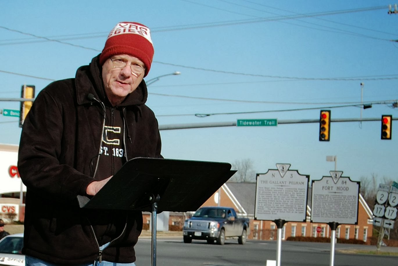
Gallant Pelham Remembered - December 13, 2013

     On the one hundred and fifty-first anniversary of the Battle of Fredericksburg, the Central Virginia Battlefields Trust dedicated a replica Napoleon 12-pounder at the site of Confederate Major John Pelham's fabled stand against the Federal advance during the early, fog-enshrouded morning of December 13, 1862. Pelham's guns boldly delayed that advance for several hours, buying critical time for the bolstering of the southern defensive position along Prospect Hill.  Click any image for larger viewing. A previous post regarding Pelham's position can be found here.

 The ceremony commenced shortly after 11:00 AM along the preserved acre in front of Family Dollar.
 Dr. Michael P. Stevens, president of the CVBT, commanded the ceremony.
     The gun crew from the Fredericksburg and Spotsylvania National Military Park wheels their piece into position for a commemorative round.

 The proud gun crew from F&SNMP listen to the presentation after their opening salute.
 Park historian Frank O'Reilly provided the background of Pelham's bold actions.
O'Reilly is the author of one of the best volumes on the Fredericksburg Campaign.
 The new, silent sentinel, guards the intersection at 10744 Tidewater Trail, Fredericksburg, VA. 


Monday, December 9, 2013

Gettysburg's Battlefield Hotel - An interesting view, circa 1870

     I'm not saying I "discovered" this image, since it is in the collection of the Library of Congress, but I only happened upon it while browsing the Prints and Photographs Online Catalog the other day. Perhaps it has gone unnoticed till now. I have no idea, but I have not seen other published references. There is nothing in the catalog listing that specifically says "Gettysburg" that I can see, but it is quite clearly the structure that occupied the intersection of Baltimore Street and Emmitsburg Road, and was called the Wagon Hotel in 1863. It is well known to have been occupied by Union sharpshooters during the battle, and was promoted as such by the sign on the corner post at the stairs. The second floor windows are later additions to the southeast wall of the building as well as the extended porch which may have served as a loading dock, serviced by the side door which was a window in 1863. A northward view of this building, taken in 1865, is available for comparison on pages 96, 97 of William Frassanito's Gettysburg - A Journey In Time, published in 1975. Renamed the Battlefield Hotel to capitalize on its historic value with tourists, the original structure was unfortunately destroyed by fire in 1895. Click on this and any of the other images for larger viewing.
The left half of the stereoview, seen in its entirety below.

No photographer's identification is apparent either on the front,
or the back of the card, seen below.

     Below is a view taken some years later (note the growth on the trees in front), from the GNMP's files according to Michael Waricher who posted it on his facebook page, Michael Waricher Battlefield Perspectives
     Below is a view of the same intersection as it appeared around 1948, also posted by Waricher, and assumed to come from the same Park files. This building was destroyed in 1949 and today the site of a convenience store and gas station, the Gateway Minimart, at 517 Baltimore Street. Emmitsburg Road, branching off to the right in these southward views, is known as Steinwehr Avenue today.
     Below, a variation of the previously mentioned photo examined by William Frassanito, and borrowed here for educational purposes, from an uncredited source posted in the website: Gettysburg Daily, in 2008. It is assumed to be from the same 1865 exposures attributed to Gardner, and is further discussed by Frassanito in his book, Early Photography at Gettysburg, published in 1995. The wartime structure is the dark brick building, seen on the left side of the image. The view is looking northward from Baltimore Street. Note as discussed previously, the absence of the second floor windows, and the first floor window that apparently was converted into a door for the later built side porch/loading dock.


Thursday, November 21, 2013

Gettysburg Address - Contrasts - 150 year anniversary challenge

     Leading up to the Sesquicentennial Anniversary of the Gettysburg Address, which was this past Tuesday; documentary filmmaker Ken Burns laid out a challenge, of sorts, to today's notables and the public at large, to learn the words, and meaning, behind Lincoln's near two minute remarks. Lincoln received five spontaneous bursts of applause from the audience which brought his total presentation to under three minutes. When he finished, some say, there was an uncomfortable silence before it was realised he had concluded, and then there was a "long continued applause". In the long run, Lincoln's ten sentences have eclipsed the two hour presentation of the keynote speaker that day, orator Edward Everett, becoming one of America's iconic documents.
     Growing up in the 1960's, my first exposure to the printed words of the Gettysburg Address came from the back of Webster's Collegiate Dictionary, in an appendix section demonstrating printer proof marks. The challenge to memorize them was instilled early on by my father who, as a Lincoln buff, naturally took pride in reciting them aloud. It became a thing we'd do together. Unscheduled, always, but something nonetheless that we'd enjoy, and will still do to this day. So when I saw a flood of YouTube videos being posted recently as a result of the Ken Burns challenge, I took notice, but hesitated in watching them, as I was interested in recording my own and did not want an external influence to alter how I have come to know it. Thus, on the 19th, I recorded my first take from my home computer, and posted it to YouTube, my first venture into that medium. From there it went to my facebook page. I found that what I had recorded was a mashup of the five "official" manuscript versions in Lincoln's handwriting. My most notable "variation" seemed to be the omission of "under God", which apparently was not in his original copy, but ended up being added on the fly that day, since the Associated Press, on-site version that made it to the newspapers of the period contained it. Because of that, I re-recorded it the next day, also wearing a collared shirt instead of my first take's t-shirt casualness.
     Today I began to watch some of the Burns PBS videos and found Jerry Seinfeld with Louis CK struggling to get it together. Seinfeld seemed to be playing the straight man. I don't know if CK truly has an appreciation for what he's learning. He never seems to come across as genuine. But perhaps that's the intent. Still, either way, I found no humor in it.

     Here are the two videos, starting with the PBS bit with Seinfeld and Louis CK, and then mine. Contrasts for sure.


Friday, November 1, 2013

Manassas National Battlefield Park, October 31, 2013

     A visit to Northern Virginia allowed for some time spent yesterday along the Bull Run and surrounding battlefield. Pleasant, mid-fall temperatures made the journey comfortable, and the thinning foliage cleared some other times difficult views. Slightly overcast skies provided soft lighting, unburdened by strong shadows. A colorful, and reflective day upon the landscape of history. 
     All images can be clicked for larger viewing.


 All photographs copyright 2013 by John F. Cummings III