Battlefield Guide Services

Wednesday, June 30, 2010

A Busy, Late June Morning at Spotsylvania Battlefield

Work has begun on the bridge for the new trail along the Mule Shoe Salient. Volunteers from Boy Scout Troop 748 began the early morning project, led by Scout David Mattes, who ably designed the bridge on CAD software. Additional volunteers came from Troop 1048. Strict guidelines were provided by the NPS Chief of Maintenance. The guidelines required the bridge had to sit on the ground surface, supported by large stones brought in for the purpose. The only digging permissible would be at the bottom of each ADA compliant ramp.  The photo below shows the placement of the north side ramp, looking west, toward the Bloody Angle. The bridge passes through a possible sally port in the Confederate line. There are suggestions that this feature in the earthworks may have been an artillery gun emplacement, or possibly a passage cut through by a farmer after the war to access his fields. Page 97 from Union surveyor L. C. Oswell's field book plotting the Salient, makes no special notation for this feature. Oswell was one of several surveyors working under the direction of Brevet Colonel James Chatham Duane, mapping the Virginia battlefields in June 1865. Without seeing the feature noted on a wartime map its true nature may never go beyond conjecture. Nonetheless, it provided a minimally intrusive means of bringing visitors from the Union side of the works to the Southern interior.
David's father, Scott Mattes, is shown below with his son's extensive design plans.
Below, the crew practices the old adage, "Measure Twice, Cut Once."
It is anticipated that the project should be completed by the end of the day, July 1st.
As the new bridge is constructed, the long standing Bloody Angle Bridge continues to provide access to visitors. This bridge will be removed as the new trail and interpretive signage are finished.
Future changes to the Park's interpretive program include the removal of larger, obstructive signs, like these known as "Happel Signs", named for the Park Historian who wrote the text for them, Ralph Happel.
Other signage slated for removal are the much older, "War Department Signs", dating back to the days before the Parks were transferred to the National Park Service from the War Department in 1933.
Seasonal Ranger Randy Washburn came up on his bicycle to observe the progress along the new trail. When stationed at the Spotsylvania Unit, Ranger Washburn rides his bike several times a day between the exhibit shelter at the park entrance and the Bloody Angle Stop to provide tours at 1:00 and 4:00.

Friday, June 25, 2010

New NPS Trail Construction - Bloody Angle

A new interpretive trail has gone into place at the Spotsylvania Battlefield. It was designed to orient visitors from the Union perspective, initially on the north side of the Mule Shoe Salient, with a stop along the way to view the swales where the Federal advance took shelter during the attack of May 12, 1864.
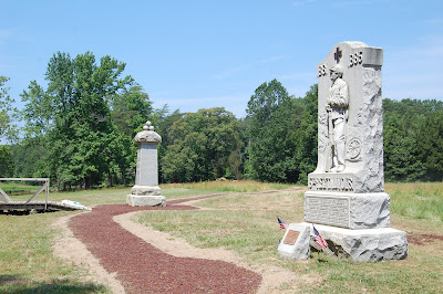
The trail proceeds toward the Bloody Angle and the monuments to the 49th New York and 15th New Jersey.
The trail then continues along the north face of the earthwork for about seventy-five yards, and comes to a sally port in the Confederate line, where a wooden bridge will provide conservation minded passage across, to the inside of the Salient.
The images below show the construction process of the segment heading up to the monuments from the parking area on Grant Drive.

Begun on Thursday, June 17, 2010, the designated path was marked on the grass with white paint, as seen on top. On Friday, June 18, the foundation for the trail was cut into place with heavy equipment, as seen in the bottom image.

On Monday June 21, and Tuesday, June 22, the trail foundation was further prepared with a base of gravel.

By 4:30 PM, on Wednesday, June 23, the laying of the rubber mulch surface had been completed, and left to cure in the sun. The mulch is made of recycled tires mixed with polyurethane, making a durable path.

The above image shows the construction looking west, along the face of the parapet, toward the monuments.

Here, the gravel bed is put in place.

The mulch mixture is applied, rolled smooth, and left to cure.

 
By Thursday morning, June 24, the shoulders were refilled and seeded.
In a few weeks, most evidence of the construction process will be hard to detect. Interpretive signage will be stationed along the way. The foot bridge will be put in place to the left of the above image, enabling visitors to pass to the inside of the Salient without damage to the earthworks. The bridge which has been in place near the monuments will be removed, eliminating a long standing intrusion at the Bloody Angle.
Continued progress of this project will be posted at future dates. The picture below is taken from the Bloody Angle, looking east, toward the 15th New Jersey monument, on Thursday, June 24, 2010.
Seen below are the monuments with the parking area at center distance. The trail can be seen as it leads up to the Bloody Angle at the extreme left edge. The old bridge will be removed shortly.

Monday, June 14, 2010

Among Buildings Now Gone - Warehouses Along City Dock, Fredericksburg

Up until the 1930s, two, large, warehouse and tenement complexes dominated the 300 block of Sophia Street in Fredericksburg. In December of 1862, they would play an important role for some of the combatants of this infamous battle. Located just up from the City Dock area, these imposing structures provided temporary shelter for Union Brigades forming up prior to their advance through town, and onto the open ground in front of Marye's Heights. Today, a small memorial stands nearby, commemorating the men of the Irish Brigade. The detail images below, are taken from what is thought to be a May 1863, panoramic view of Fredericksburg, as seen from the Stafford County side of the Rappahannock River.
For our purposes here, we will call them "Complex A", the one furthest south, and "Complex B", nearer to the intersection with Frederick Street.

Complex A, looking abandoned and possibly showing effects of
the Union shelling of the town. Note what may be a puncture
through the brick wall between the upper floor windows, on
the left most portion of the main structure. Click picture for greater detail.

Complex B


Complex A, photographed in the late 1920s or early 1930s, by Frances Benjamin Johnston.
During this final stage of its existence, the buildings served as a "Pickle Factory." It is difficult to see if there is easily identifiable repair work to the brick wall, as mentioned in the description of the May 1863 view. Click picture for greater detail. Complex B is also visible from this angle, its northern most portion ending before the cluster of barren trees at right. Photograph from the Library of Congress, Prints & Photographs
Online Catalog.

Modern view of the Complex A site, showing how the City of Fredericksburg
 has reclaimed the river front area for public park use. June 2010.

Complex B as seen in another view taken by noted
photographer Frances Benjamin Johnston. Here it functioned
as a "Hoop-Pole Factory." Photograph from the Library of Congress,
 Prints & Photographs Online Catalog.                                     
The now empty landscape of Complex B.
June 2010

As quiet as it usually is today, it is sometimes hard to imagine the thousands of soldiers that stood in regimental marching order, shoulder to shoulder, here. Many never returned to this area alive after the fatal fighting of December 13, 1862. In May 1863 and 1864, the Union Army would return again to these sites as part of the Chancellorsville Campaign and the Overland Campaign, respectively. 

Wednesday, June 9, 2010

Summer Is Almost Here - The Butterflies Are Back

Bull Thistle along the road to the McCoull House has attracted
a pair of Pipevine Swallowtail butterflies.

The Pipevine Swallowtail, up close.

A Tiger Swallowtail enjoys the Butterfly Weed near the
former CCC building on the McCoull Farm.

Honey bees also love Butterfly Weed.

                             
Large crops of Butterfly Weed thrive on the battlefield.


Sunday, June 6, 2010

Battle Damage Part 2 - The still visible effects of shot and shell today

Notice: I am modifying this entry to reflect clarification of information gathered today, June 7, 2010. The home referred to here, was indeed owned and occupied by Robert C. Dabney until his death in 1875. It was not until Jan 16, 1880 that the property was purchased by John R. Alrich. My originial notation of Alrich owning prior to the Civil War came from a statement made in the obituary of his great-grandson, John R. Alrich who died October 1, 1987. The statement from the October 2, 1987 issue of The Free-Lance Star newspaper states: "A native of Spotsylvania, Mr. Alrich lived in a home near Spotsylvania built by his great-grandfather before the Civil War." Deeds on record at the County Circuit Court indicate this is apparently not true, unless of course we can find that he was in fact the "builder" as opposed to the "owner" as had been assumed within our initial posting. 

Standing today, in the middle of what would have been considered “no man’s land” in May 1864, the “Alrich House” survives as a silent testament to the fighting that coursed over the surrounding landscape. Roughly a third of a mile north east of Spotsylvania Courthouse, on Route 208, it sits opposite the Spotsylvania Confederate Cemetery. Commonly marked on Civil War era maps as the residence of Spotsylvania Circuit Court Clerk, Robert Clarence Dabney (1822-1875), the home was built according to estimates between 1846 and 1855. A further search of County documents should hopefully clarify this date. The Greek Revival brick structure was purchased in 1880, by John Roberts Alrich (1833-1907), a native of Delaware who had sided with the Confederacy in March 1862, serving initially in Company E of the 9th Virginia Cavalry, a unit which was comprised of numerous Fredericksburg area residents. John Roberts Alrich and his family have also been associated during the Civil War, with a house at the intersection of Old Plank and Catharpin Roads, near the Chancellorsville battlefield. Again, additional scrutiny will be required to hopefully get a clearer picture. Nonetheless, the former "Dabney" home remained the residence of the Alrich family up until December of 2009, with the passing of Alice R. “Bobby” Alrich (1949-2009). Alice was the daughter of John R. Alrich (1914-1987), the great-grandson of John Roberts Alrich, the Confederate veteran.

On Saturday, June 5, 2010, the contents of the estate of Alice Alrich were auctioned off. Being open to the public, it allowed a rare glimpse of the brick home and outbuildings. As suspected, the exterior wall facing the north east shows numerous pockmarks caused by Union case shot and canister rounds. Union batteries were at various times during the Spotsylvania Campaign as close as half a mile from the house, firing down the Courthouse Road corridor. Visible are three iron balls, in two sizes, secured in place with mortar. It may be possible that the iron projectiles were cemented in place to embellish the fact of war damages, but the home was not, at least in recent times, open to visitors. It had been a seemingly common practice in the mid twentieth century, to place projectiles found on a property in damaged areas of brick, as evidenced by the Stone House of Manassas battlefield fame. There is no doubt however, to the source of the surface damage on the brick wall. It is fortunate the home did not suffer more direct and severe damage as it stood nearly 400 yards in advance of the entrenched Confederate position near the Courthouse. An inspection of the attic may reveal damage to roof rafters and possibly embedded, whole shells, something that has turned up at other area structures.
The only remaining period outbuilding on the Alrich property is a brick smoke house that shows considerable repair which may have been the necessity of war damage as well.

The wall facing north east. Enlarge the picture by clicking it.  
 Red arrows point to the damaged areas and cemented iron balls.

Detail views of iron balls, cemented in place.
The long crack seen in the picture at right was
caused by freeze/thaw damage.
This wall supports the inside chimney.
Impact damage from Union artillery, high up on the wall.
Impact damage from Union artillery.
The brick smoke house behind the home.
The smoke house, as seen in the 1930s, for the
Historic American Building Survey.
A wooden kitchen and or laundry stands to the left.
Photograph from the Library of Congress.
A similar view today shows the smoke house still standing with
twentieth century additions added to the Alrich house.
The wooden outbuilding is long removed.