Our friends over at the Fredericksburg & Spotsylvania National Military Park have developed an excellent blog, Mysteries and Conundrums, which allows us an inside look at many of the discoveries and considerations they make while adminstering the battlefields in their charge. In the past few days, NPS Historian Eric Mink, has presented an in-depth examination of the process involved in the creation of the current Chancellorsville Visitor Center here. Planning had begun in earnest in the 1950s for the site, with the actual project being constructed in the early 1960s. One of the heaviest considerations during that planning was how and where to place the structure with the least amount of encroachment to the historic lanscape. Exacerbating the frustration was the then future plans to widen Route 3 through the battlefield, something that the Virginia Department of Transportation had already drawn up. It would not be until the 1970s, but the transformation of the historic Plank Road, into a divided, four lane highway, would take a great toll on the visual integrity of the landscape. The once rural area and its primary artery would be forever altered.
The following images present a look at the monuments placed near the north shoulder of the road right-of-way, since circa 1876. The monuments were placed to mark the vicinity of General "Stonewall" Jackson's mortal wounding on the evening of May 2, 1863. All images are clickable for larger viewing.
Looking north from the Plank Road in an early 1900s postcard.
This monument was dedicated June 13, 1888.
The same view today from the west bound lane of Route 3.
The VDOT right-of-way has cut a deep swath in front of the monument.
A "linen" postcard from circa 1940s -1950s, looking west at the
Jackson monument and Park Contact Station.
The exact same view today, with obscuring foliage.
A circa 1950s - 1960s "chrome" postcard taken from the
north shoulder of Route 3, looking easterly. Note boulder at right.
An approximately similar view today, with a look down Route 3.
An amazingly rare, quiet moment in traffic flow.
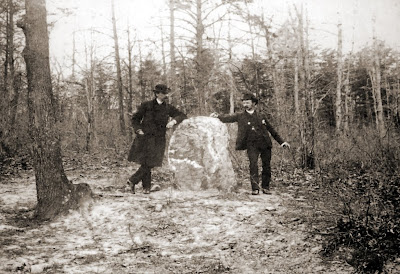
An early view of the first marker, placed September 22, 1879.
UPDATED: This date of dedication for the quartz marker was discovered
by NPS historian, John Hennessy, in October of 2012.
The same boulder today, much reduced in size by souvenir hunters, and
almost lost in the maze of trees and shrubs. An effort to access.
Both monuments today, looking east, from inside the NPS boundary.
The concealing growth at right serves as a guard rail of sorts to keep
visitors from tumbling down into the Route 3 right-of-way.
The boulder is beyond the 1888 monument, in amongst the foliage at center.


1 comment:
Another great then-and-now, from a master of the genre. Thank you for sharing this, John. Noel
Post a Comment