Battlefield Guide Services

Friday, May 23, 2014

O'Sullivan's Bethel Church Photographs - In Real-time - May 23, 2014 - A Sesquicentennial Examination

     Your blog host visited the site of General Burnside's temporary headquarters at Bethel Church today. Situated at a country road intersection, known these days as Paige, VA, this still active congregation sits about five and a half miles east of modern Route 1, and roughly nine and three quarter miles southeast of the Massaponax Church, site of my May 21st posting. Burnside occupied the church from 2:00 P.M. on May 22, until about an hour after sunrise on the 23rd. I arrived there myself, about 10:30 A.M., to make certain I would be around at the same time as photographer Timothy O'Sullivan, 150 years later, to the day. As it turned out, I would have about an hour long wait, watching the sun rise higher in the sky, and the shadows it created on the building grow longer. In that time I remained, for the most part, the lone occupant of the site, with the exception of five bicyclists that took a breather nearby, a mailman on his rounds, and sporadic through traffic. At the end of this post, the reader will find a two minutes video, shot while waiting for the sun to shift, where I discuss the movement of the shadows, and accounting for the differences in time from 1864 to today. In the past century and a half, the Earth's rotation has sped up and slowed down, it's a fact, but we are speaking of microseconds, and the Earth does wobble a bit, with many factors, including earthquakes, the gravitational pull of the sun, moon and other planets factoring in. But, we can, within reasonable expectations, be comfortable that we are seeing things pretty much as O'Sullivan and the soldiers he photographed that day, saw things, in real-time. I was also fortunate to have one unexpected condition answer a question that arose as I moved my camera about to near the same locations as my wet plate wielding predecessor. I will explain that further down.
O'Sullivan's stereoview, looking northwesterly, at about 10:13 A.M., Civil War time.
The view today, 150 years after, at 11:24 A.M., modern time.
O'Sullivan's southwesterly view, somewhere probably before or after the previous image.
I hesitate to place a time on this image, outside of the date, with any certainty, due to the
lack of strong shadows cast on the building. The large tree, and the figures are silhouetted,
giving indication that the sun is most likely in the same position as in the previous view, but...
...here is a modern view, taken at 11:28 A.M., modern time, under an atmospheric
condition alluded to at the top of this post. What had me wondering, and I do
speak of it in the video below, is the absence of strong shadows in the period
image. And amazingly the answer presented itself, right as I set up to take the
present day view. Clouds! Scattered clouds blocked the sun right when I needed
them, and demonstrated that O'Sullivan was working with the same conditions.
The cloud cover creates a diffused light, softening the contrasts on the building walls.
And in this view, taken at 11:29 A.M., a minute later, the sun has again emerged,
showing that indeed the strong shadows are again revealed. After that the clouds
 pretty much burned off for several hours. I certainly felt blessed. Mystery solved.
Here is a full frontal view of the church, looking slightly southwest, taken at 11:25 A.M.,
modern time, which would approximate at 10:14 A.M., Civil War time, showing the 
configuration of the shadows seen in the first O'Sullivan view, at top. In the video
below, I go into a brief discussion of where the shadows fall on the easily 
countable courses of brick in the 1864 images. For all intents and purposes,
we are looking at Bethel Church at exactly 150 years after O'Sullivan's images.


Enlarged detail, with adjusted contrast, to reveal the shadows of approximately,
10:13 A.M., on the morning of May 23, 1864, as photographed by O'Sullivan.
Compare with the modern image seen above the video.

Wednesday, May 21, 2014

Massaponax Church, VA - Grant Writes a Dispatch - 150 Years Ago Today, To the Hour, In Real-Time - 5/21/2014

     In the late morning of May 21, 1864, Generals Grant and Meade met at the corner of The Massaponax Church Road and the Telegraph Road, known today as the Jefferson Davis Highway, or Route 1. At the Massaponax Church, pews were brought out for the "Council of War" about to take place at this crossroads. In the background of four images, taken from a second floor window by photographer Timothy O'Sullivan, a long train of wagons is passing, many with the emblem of the Union 5th Corps painted on their canvas sides.   Click any image for larger examination.
Timothy O'Sullivan's photograph, Gardner negative # 731, "Council of War": Gen. Ulysses S. Grant writing a dispatch. Approximate Civil War time is 10:47 A.M., based on a modern time of 11:58, for the image below.
Your blog host, sitting at the approximate location of the pew where Grant was seated. 
Taken from ground level, but from a slightly elevated and similarly angled view as O'Sullivan's.
Massaponax Church Road runs behind, intersecting with Route 1, the former Telegraph Road,

Your blog host reads the dispatch assumed to be the one Grant is writing in O'Sullivan's image.

                     
     A fifth image was also taken that morning by O'Sullivan, approximately 45 minutes prior to the "Council of War" series. This view was taken from the eastern side of the intersection, looking approximately west. Members of Meade's headquarters guard, the 114th Pennsylvania Infantry, can be seen mingling amongst the soldiers gathered in the church yard. Based on shadows cast on the front of the church, we can approximate the time this image was taken as 10:00 A.M., Civil War time.
     Today, with adjustments for daylight savings time and railroad time, the modern time is 11:15. Strong shadows seen below the fascia today, are created by  a gutter that did not exist on the structure in 1864.
     An enlargement from Gardner negative # 729 shows the "time stamp" like shadows, on the front of the church. The shadow from the overhang above the fascia covers all but two course of brick above the windows. 
     A modern view taken from up close at 11: 24, demonstrates a slight lengthening of the shadow in the 9 minutes that has passed, as the sun reaches higher in the sky, and diminishing the width of the shadow at right.
     O'Sullivan's camera was positioned in the upper half of this window. The balcony floor can be seen just above the first row of panes on the upper sash.
     The two camera positions, marked by red flags, (A) inside the church, looking south, and (B) on the east side of the intersection, looking westward. Click for larger examination.

Tuesday, May 20, 2014

The Morning After - May 20, 1864 - Timothy O'Sullivan's Confederate Dead on the Widow Alsop Farm

     It's now one hundred and fifty years since the grim harvest of the fighting at Harris Farm was documented by photographer Timothy O'Sullivan. Three years ago I posted a piece about O'Sullivan's images, and that post can be visited by clicking this link. It continues to be one of this blog's most visited posts. Most of my popular posts seem to deal with death and graves. I suppose it is the sad nature of what I discuss here, something that is difficult to minimalize, the fact that war is ultimately about death, destruction, and decay, but it is sobering on some level to realize this is what an audience seeks.

     It now being the actual sesquicentennial of that morning, I had considered a simple reprise of the March 24, 2011 piece, but having experienced the past few weeks of observances around the Spotsylvania region, with battle re-enactments, real-time walking tours, and contemplative memorial gatherings, I feel it is appropriate to add something more, something that sets the final tone of the moment. I will borrow from myself, a brief description of what remained on the Widow Alsop's property. This first appeared as a comment to a post by NPS Chief Historian John Hennessy on the park's excellent blog, Mysteries and Conundrums. It discusses the Alsop farm images and what they reveal. That piece can be visited by clicking this link. Another reader had commented that the Confederate dead in O'Sullivan's images did not appear to be as effected by decomposition as one might imagine, considering they had been killed the day before. The following is what I offered:

"With the photographs being taken late morning to early afternoon, we can estimate that some of the bodies have been dead around 17-19 hours. Rigor Mortis is clearly visible in most as evidenced by arms, legs, and hands. The ambient temperatures between the time of death and the taking of these images probably ranged from the mid to upper 50s or lower 60s to the upper 70s or lower 80s. The rate of decomposition looks to be within reason. The one detail that the camera would not have captured though would be an abundance of blow flies. It is interesting that the ground looks relatively dry despite the heavy rain that is reported to have fallen after the fighting was underway. The body supported by the fence corner does appear to have evidence of lingering moisture in the clothing, particularly around the midsection where it would have essentially drained to and collected as time went on. Interesting, under magnification it is clear this man was also attempting to stem the flow of blood from his chest or upper abdominal wound. A blood soaked cloth protrudes from his open shirt and vest, so we know he did not die instantly. It is also clear that his pockets have been ransacked after death as they are all turned out. This is most probably the position he assumed as he expired, with his head fallen backward and his exhausted arms fallen to his sides. One will note that as he was placed on the stretcher, to be carried over to the Alsop house to be buried, his arms still maintain, due to the rigor, the bend they assumed as he lay propped up, although he is now laying flat. The face of the one man you are specifically wondering about shows a typical relaxed drooping of the tissue, and fixed stare, but I will suggest that he and the man immediately next to him may have been two of the last to die that evening, for, and I hate to say it, they do look the “freshest”."

Below, are three details of the one body that I have primarily referred to above.


Below, the other two bodies referred to at the end of my reply. 


     As I prepare to publish this post, it is now a century and a half since burial crews made their way across the farms of Harris, Alsop, and Peyton, A grim task they undertook. The bivouac of the dead...


Monday, May 19, 2014

My Personal Spotsylvania - Pvt. Frederick Unger Wounded During Harris Farm Battle May 19, 1864

     Today marks the one hundred and fiftieth anniversary of the wounding of my triple great grandfather, Frederick Unger, during the fighting known as the Battle of Harris Farm. Five heavy artillery regiments, newly transferred to create a revised 4th Division for Hancock's 2nd Corps, arrived at Spotsylvania from the outer defenses of Washington, D.C. on May 17, 1864. These men, trained as infantry, but having manned large siege cannon in the ring of forts protecting the nation's capital, had not yet fired their weapons against enemy troops. This would all change in the early evening of May 19, as Confederate 2nd Corps troops under Ewell, made a bold effort to break the Union right wing on three farms north of the Courthouse Road. The battle, collectively known as the Battle of Harris Farm, would cover ground across the Harris, Alsop and Peyton properties. My ancestor was a private in Company "G" of the 7th New York Heavy Artillery, recruited from the Albany area. Unger was a cabinet maker before entering the service on August 13, 1862. At age 38, Unger was already suffering from rheumatism before this engagement, but this would not exclude him when the 7th left Fort Reno on the morning of May 15. 
     As evening came on May 17th, the regiment made its way along the dark road toward Spotsylvania. About three miles from the Courthouse, four companies at the end of the column, guided by Major Francis Pruyn, became separated from the rest  of the 7th, and turned left at a fork in the road where their now unseen predecessors had gone to the right. 
     Looking southeast where the wartime Courthouse Road (modern Foster Road), intersected with Smith Station Road turning to the right. The four lagging companies, having lost site of the head of the column, continued to the left in the darkness.
     The four companies, now lost with Major Pruyn, bivouacked in this field at center, just north of the Ni River, late in the evening of May 17, 1864. The property is part of the historic Gayle Farm on the east side of modern Route 208.
     The intersection of  modern Treemont Lane with Courthouse Road, looking northeast, with the modern Ni River Bridge in the slight valley at center. The wartime path of the Courthouse Road would have emerged from the edge of the trees at extreme right, then heading directly toward the camera position. On the morning of May 18, 1864, the 7th entered the woods near the location of Treemont Lane, cutting across country to the northwest, toward the sound of distant fighting. They would arrive to meet the rest of the regiment near the Landrum Farm, but too late to participate in the fighting against Lee's new line, south of the abandoned Mule Shoe Salient. Later that morning the 4th Division had been repositioned to bivouac for the rest of the day, in a large field across the Courthouse Road from where Major Pruyn had camped the four companies the night before.
     Looking northwest at the field where the "Heavies" bivouacked on May 18, 1864, in the taller, greener grass at center of the image. In the distant wood line, a small stream feeds into the Ni River, out of view to the extreme left.
     In the afternoon of May 19, the Heavies were relocated northeast, and were inserted into the right wing of the Federal line where they would have their first combat against an incursion by Rhodes's Division of Ewell's Second Corps. This view is looking west, across the ground that the 7th traversed to confront Ramseur's and Grimes' North Carolina Brigades near the site of the Widow Alsop's Farm House. Somewhere in this area, Frederick Unger would receive a bullet wound along the underside of his left arm, the ball entering above the wrist and exiting above the elbow. Apparently Unger was in the action of aiming his rifle, with an outstretched left arm, supporting the barrel of the gun, as the enemy projectile traced along the forearm, slightly gouging the bone as it went. The wound would be treated in the field, and Unger was later sent north to recuperate in several hospitals before he would eventually return to service. His daughter Louisa would become my great great grandmother, having married Chauncey Smith, the son of another Civil War veteran, Jerry Smith, also from Albany, New York, and serving in the 18th New York Cavalry. Frederick Unger would die on January 2, 1883, from a heart attack that struck him as he walked home from a GAR meeting. He was only 57. Sadly, there is currently no known image of Frederick Unger, but I do have a picture of the Assistant Surgeon that treated his wound at Harris Farm.
     A 7th NYHA reunion ribbon featuring Surgeon George Hopkins Newcomb, who, while Assistant Surgeon for the regiment, treated Frederick Unger at a field hospital in, or near, the Harris House.

Friday, May 16, 2014

A Chance Encounter and the Proof of Courage - 23rd USCT's at Spotsylvania Will Be Remembered, May 17

   
Photograph by Robert Szabo, 2013.

     Spotsylvania County has the distinction of being the location of the first armed encounter of United States Colored Troops against Robert E. Lee’s Army of Northern Virginia. This badge of honor took place on May 15, 1864, at the intersection of Catharpin and Old Plank Roads, two miles southeast of the ruins of the Chancellor House on modern Route 3, and Ely’s Ford Road. The 23rd was a new regiment, freshly recruited and trained in the Washington, D.C. area from former slaves, a good number of whom had borne the weight of chattel labor to owners in Fredericksburg and the surrounding region. The incident was a chance encounter, but one that seemed to be rooted in destiny for these men. Up until this skirmish, black troops had not been entrusted to combat service in the eastern theater of the war. Union command in the Army of the Potomac had greeted the inclusion of black soldiers with great hesitation, fearing that they would turn and run under the stress of combat situations, or simply throw down their weapons and go back to their masters. Thus, on this fateful day, these men proved their mettle, setting an example that would illustrate their worth as fighting men through to the end of the war. On this day, the regiment had been relegated to guarding army baggage trains parked by the Chancellor ruins, well behind the lines of fighting during the battle of Spotsylvania.
     Probing the rear of the Union Army on this morning, was a high spirited Confederate cavalry brigade commanded by General Thomas L. Rosser. The Confederates were traveling along Catharpin Road, feeling their way toward a crossing of the Ni River, near the Piney Branch Church, when they encountered the 2nd Ohio Cavalry. The Ohio troops were caught by surprise, having just enjoyed some leisure time and a quick meal. A number of the Union troops had disassembled and oiled their carbines, allowing the parts to dry in the sun. No one had anticipated an encounter with enemy forces this far behind the fighting. Unable to muster an appreciable force to stem the flow of the enemy advance, the 2nd Ohio quickly mounted and began a mad dash northeastward, along Catharpin Road, toward the Alrich Farm, two miles away. Amazingly, word of this potential disaster reached the 4th Division of the Federal 9th Corps, of which the 23rd USCTs were a member. Being the closest troops available to respond, the 23rd raced at the double quick, toward the fast approaching rebel brigade.  Their two mile dash brought them full face into combat. Wheeling the regiment to the right, they entered the intersection and adjacent fields in perfect form, brought their rifled muskets up and fired into Rosser’s stunned advance. This caused the Confederate force to wither and fall back toward a tree line within which they hoped to make a stand, but a now reenergized 2nd Ohio pursued them and sent them in full retreat, back down Catharpin Road, towards Todd’s Tavern.
     The 23rd went on to serve valiantly for the remainder of the war, taking heavy casualties during the Battle of the Crater at Petersburg on July 30, 1864.

     In anticipation of the opportunities available during the Civil War Sesquicentennial to tell the story of the 23rd, your blog host began a conversation in the fall of 2010, with friend and fellow historian Steward Henderson, about assembling a representative unit as re-enactors to portray the regiment. Now, nearly four years after the initial discussion, the plan has come to full reality. Tomorrow, Saturday, May 17, 2014 we will properly remember the 23rd and the day that brought them to glory. From 9 A.M. till 1 P.M., the 23rd and members of other USCT units will present a living history encampment at Chancellorsville's Tour Stop 10, Fairview. At 1:00 P.M., a 45 minute presentation "The Rise of the USCT" will be given by NPS Chief Historian, John Hennessy. At 2 P.M., the 23rd will lead a procession down the Old Plank Road, in the footsteps of the original regiment, arriving at the intersection with Catharpin Road, the site of the skirmish. On the ground where they fought, there will be a commemorative program and a nearby dedication of a new Virginia Highway Historical marker describing the action. All are welcomed to come out and join in the procession. 
Photograph by Lou Carter Jr., 2011.

Wednesday, May 14, 2014

The Destruction of the Myer Farm, and the Death of a New Jersey Colonel at Spotsylvania

     The farm of John Henry Myer had been a bucolic delight, occupying a prominent rise above the Ni River valley, and scarcely a mile and a half east of Spotsylvania Courthouse.
     The Myer family had purchased the land in late April 1863, and the distance it provided from the horrors of war ravaged downtown Fredericksburg had been a major consideration in the transaction. John Myer, the father, had emigrated from the Kingdom of Hannover in 1846, making Fredericksburg the home for his growing family and the location of his prospering bakery enterprises on William Street, backing onto Market Square. Agriculturally, Myer was looking to transition the fields to wheat which would provide his own flour. The previous owner, Mordicai Gayle, had concentrated on tobacco, as many of the surrounding Spotsylvania farms had done.
John Henry Myer before the war, as a young entrepreneur.

     Just a year after their exodus, John Myer was conscripted into the Confederate service, and as if by fate, the war he was entering came virtually to the doorstep of his home. Positioned in a landmark earthwork known today as Heth’s Salient, the 40th Virginia Infantry were just two miles west of his farm, and on May 15, 1864, billows of black smoke ominously filled the sky above the idyllic homestead. The Union Army was burning his property in a retaliatory move caused the previous day by the rash actions of an entrusted tenant, Thomas Jett. Jett had introduced himself to the occupying Union forces on the morning of May 14, 1864 as noted in the Official Records. When the tide shifted later that afternoon, and overwhelming Confederate numbers took the ground back, Jett brashly fired upon the retreating blue coats with his personal weapon, but the Confederate victory was short lived, and the Union retook the hill with relative ease as the evening came on. Daniel M. Holt, the Surgeon of the 121st New York, reflected in his diary entry of May15th, "Again upon the ground lost yesterday. Our Brigade in front as skirmishers. Remain all day. The most quiet one of the campaign, so far. No picket or other firing heard. Encamp for the night in a log cabin, the last of Negro quarters. We burned the large house and outbuildings because the owner was a rebel and upon our evacuating yesterday, fired into our "demoralized" ranks. It was a good building and its destruction helped to pay for that shot."
Of course it was not Mr. Myer, the true owner of the house, who fired that shot, and thus he would unwittingly suffer for the misdeed of a man he entrusted as caretaker while he was away, fighting in a war he wanted no part of.
     Further exacerbating the Union force’s ire against the Myer property was the death of Lieutenant Colonel Charles Wiebecke of the 2nd New Jersey Infantry. Wiebecke and his men had been thrust into the action of May 14th almost as an afterthought, providing a modest bolstering of the defensive line that afternoon. Sent forward as support for skirmishers examining a suspected Confederate advance, the Jersey men ended up taking the solid brunt of the attack when the suspicion proved all too real. The regimental chaplain for the 2nd later described the incident, “Suddenly, the enemy advanced in overwhelming force, and the Union skirmish line fell back thro’ its supports, thus leaving Colonel W with his men in front. Their well directed fire broke the rebels’ first line. But other lines of battle continued to advance. At this moment, Col. W. raised himself from behind the protection of a few rails, whence his men were firing, to reconnoiter the advancing foe. While so doing, he was struck by a bullet, which entered at the right eye, penetrated to his brain, causing instant death.” The Colonel’s body was left in Confederate hands for several hours before the Union retook the hill, and in that interim, the chaplain explains to Wiebecke’s widow, “…the barbarous foe had plundered your husband’s body of his watch, his money, and most of his clothing.”
    This maltreatment of the body inflamed the men of the rank and file, and by dawn of the next day much of the personal property was wrecked prior to being set to the torch. 
Lt. Colonel Charles Wiebecke of the 2nd New Jersey
from a reunion ribbon in the author's collection.
Your blog host portrayed Wiebecke in a documentary film in 2004.
Photograph by Robert Szabo.

     On May 22, 1864, seven days after his Spotsylvania home was destroyed, John Henry Myer was captured near the North Anna River and spent the rest of 1864 as a POW at Point Lookout, Maryland. He took the oath of allegiance on December 15 and returned home to Fredericksburg. In 1866 he sold his decimated Spotsylvania farm at a considerable loss, but went on in the postwar years to become one of Fredericksburg’s most successful business men and community leaders.

     Today the property sits begging for attention. The woods surrounding the house site were logged in recent years, damaging sections of delicate earthworks that remained from Union occupation. Much of the land is covered in heavy secondary growth.
NOTICE: THIS PROPERTY IS POSTED.  TRESPASSERS WILL BE PROSECUTED.

Myer's Hill, Spotsylvania - Only Known Period Image - Dated May 10, 1864

     Today marks the 150th anniversary of an engagement that resides in the category of great "what ifs". In the early morning hours of May 14, 1864, General Grant was about to face another frustration in his efforts to strike down Lee's Army of Northern Virginia. An intended stealth maneuver of the Federal 5th and 6th Corps had literally bogged down in the mud of Spotsylvania County during a night march. The plan was to extend the Federal left and strike at the Confederate right, weakly held near the Courthouse. A scheduled 4 A.M. attack down the Courthouse Road would be an impossibility. At 6:00 A.M., Meade communicated the disappointing news to the General-in-Chief, "Warren reports the head of his column just arrived. The column broken and scattered. He doubts the practicability of getting his command into a condition to do anything today. General Wright has also just reached here, and I have directed him to move over to the Massaponax Church road and mass out of sight of the enemy." 
     A slow, but steady trickle of Union men continued to make its way down the road, and they extended their left across the fields of the Gayle and Beverly farms, the latter being on the south side of the Ni River. In the overcast morning light, Confederates on a slight rise, a mile southeast of Beverly, observed the movement of Warren's men. The southern force consisted of a portion of Chambliss' Cavalry Brigade, supported by McGregor's Battery of Horse Artillery. The property they occupied was known alternately by several names, Bleak Hill, Gayle, Galt, and most correctly for the time, Myer's Hill. The Myer family had acquired it the year before, just as the Chancellorsville Campaign was erupting nine miles to the northwest. The paterfamilias, John Henry Myer, on this morning was stuck in Heth's Salient along with the 40th Virginia Infantry, into which he had been recently conscripted.
     To simplify for this posting, by the time the sun had set on May 14th, the Myer farm would be contested twice. During the second episode, General Meade came close to being killed inside the Myer House by McGregor's guns as they opened fire around 4 P.M.; and while barely escaping toward a crossing on the Ni, he would almost fall into the hands of a bold Confederate Major who reached out to grab him. 
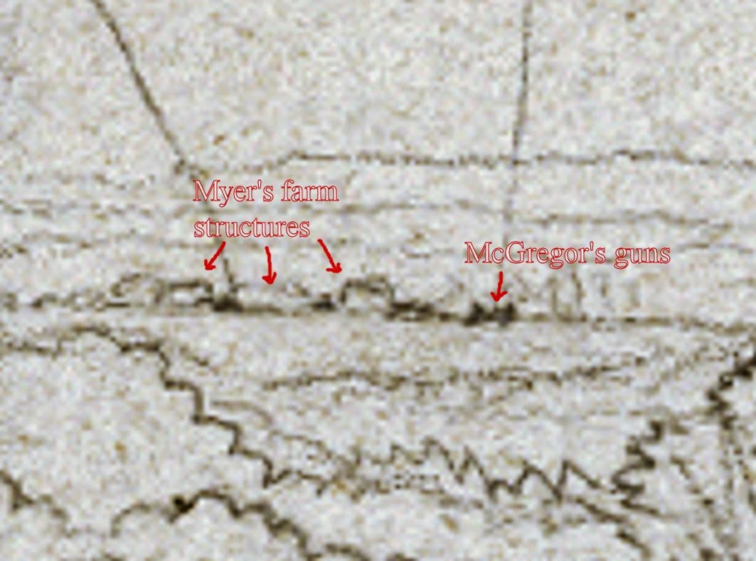
     Four days prior to this action, a special artist for Frank Leslie's Illustrated Newspaper, Joseph Becker, created a two page panoramic sketch of 9th Corps troops advancing down the Courthouse Road, passing over the Gayle farm on the left. In the middle of the scene of the left hand page, the Beverly Fam sits atop a rise beyond Gayle. And, most interestingly, situated on the horizon line, above the Gayle House, is a small annotated detail which depicts the Myer House and surrounding outbuildings. McGregor's guns are identified as "Rebel Bat" to the right of the structures. McGregor and Chambliss had occupied the summit as pickets since the 10th. Click the following images for larger examination.
Detail from the Becker sketch, showing Myer's Hill at left of center horizon line.
Closer detail showing Myer structures and battery. My annotations in red.
The full, left page of Becker's two page panoramic sketch.
Courtesy of the Becker Collection, Boston, MA

Further details of the Becker Collection are available at the following link: http://idesweb.bc.edu/becker/about

Tuesday, May 13, 2014

The Morning After - May 13, 2014 - Where Alfred Waud Sketched, 150 Years Ago Today

     And now it's all over. Thousands of visitors had come and gone for the past ten days. They came to walk the ground hallowed by the blood of two armies, a century and a half after the fact. Many came to honor their own ancestors who fought and died here in Spotsylvania County. Some freely acknowledge their families came to America after the Civil War. It's the strange allure of the conflict, the defining drama of our nation. Others can't define what brought them. But there is a kinship amongst all that came out to see the very ground, and hear the horrific accounts of the vicious struggle. And they ended their pilgrimage on this now quiet field. Quiet for yet another day. For twenty-two hours, starting around 4:30 on May 12, 1864, it was hell on earth. Few who survived that day would write about it. It was that traumatizing. But those that did write their memoirs years later would leave little doubt about the ghastly aftermath. A private of the 95th Pennsylvania Infantry, G. Norton Galloway, described what he witnessed in the early morning of May 13, 1864:  "A momentary gleam of sunshine through the gloom of the sky seemed to add a new horror to the scene. Hundreds of Confederates, dead or dying, lay piled over one another in those pits. The fallen lay three or four feet deep in some places, and, with but few exceptions, they were shot in and about the head. Arms, accouterments, ammunition, cannon, shot and shell, and broken foliage were strewn about. With much labor a detail of Union soldiers buried the dead by simply turning the captured breastworks upon them. Thus had these unfortunate victims unwittingly dug their own graves. The trenches were nearly full of muddy water. It was the most horrible sight I had ever witnessed."

May 13, 2014, 6:34 A.M.
     Above, an embellished sketch by newspaper artist Alfred Waud, was drawn May 13, 1864, when the location was actually free of engaged troops. What Waud would have come upon was a field strewn with bodies of the dead and the associated debris of war. Harper's Weekly's "special artist" was an accomplished landscape artist and he accurately depicts the ground before him. The viewer can click the image and examine more closely the mastery of his craft. Notice that the bodies of the dead are of a slightly larger scale and are placed on the paper in a sketchy, quick hand. The figures of the soldiers doing the fighting are executed with more refinement, filled in after Waud would have returned to a conducive work space. It is also interesting that he included a conference of seemingly unfazed officers in the right foreground. Although Waud, and the other newspaper special artists of the day are characterized as having crawled toward an engagement and sketched a battle as it unfolded, I have no illusion that he would have done so at this hot a location. This sketch was later turned into an engraving and published in the June 11, 1864 issue of Harper's Weekly on pages 376-377.
     On October 11, 2009, I enlisted the assistance of National Park Service historian Eric Mink to confirm the location from which I believed Waud had made his base sketch. I established a static camera position with the camera on a tripod, and then directed Eric to assume various poses in the approximate locations of the figures Waud created from his skilled imagination. In all, Eric kindly repositioned himself sixty-three times across the landscape, including the distant prolongation of the Federal line that created the "Bloody Angle", the area where Waud depicted the heavy billowing of gunsmoke at middle right. As seen above, I then digitally combined all the "Erics" into a finished piece.
     A few years later, a rubberized mulch trail was installed across the position of the kneeling Union soldiers, along with an interpretive sign utilizing Waud's drawing. 


Sunday, May 11, 2014

Death of Major General John Sedgwick - 150th Anniversary, On Location, To the Minute


     National Park Service Historian, Frank O'Reilly, met an appreciable gathering on Friday, May 9th, to commemorate the life, and tragic death, of Union Major General John Sedgwick. Standing in the clearing where Sedgwick played out his final moments, those present were experiencing that drama 150 years later, to the hour, and to the minute. O'Reilly vividly recounted the moments that led up to Sedgwick's famous admonishment of his men, "I am ashamed of you! They couldn't hit an elephant at this distance!"
     The General was struck somewhere around 9:00 A.M., Civil War time, approximately 10:11 A.M. modern time, making adjustments for daylight savings time and railroad time.

     Your blog host filmed this presentation with the camera facing the direction Sedgwick faced, looking toward the open field to the left distance, the location from which the concealed sniper would fire the shot that killed the highest ranking officer on the field of battle during the Civil War.
Click the images below for larger viewing.
   
 Looking southward from behind the monument to Sedgwick, which stands on the spot where he fell. 
 Looking somewhat northeast, with the Park's exhibit shelter at the left distance.
 The monument was dedicated on May 12, 1887.
  Frank O'Reilly, articulating a point at 10:34 A.M., nearing the conclusion of his presentation. 
     At the conclusion of the presentation, Frank O'Reilly and your blog host stand facing the field from which the sniper took aim, demonstrating the sun's illumination on Sedgwick's face before being struck on the cheek, below the left eye, just to the side of the nostril.
     View from the sniper's assumed position, on an elevation roughly 445 yards south of the Sedgwick monument. The monument is just inside the notch at the middle of the woodline, where the Brock Road begins to disappear from view.

Thursday, May 8, 2014

"Literally Shot To Pieces" The Mortal Wounding of Corporal Emerson Rude - May 7, 1864

     Around 3:00 P.M., on Saturday, May 7th, 1864, the men of the 1st New York Dragoons dismounted about a mile south of Todd's Tavern, along the Brock Road. Pressure was being applied to Confederate forces blocking the direct path to Spotsylvania Courthouse. Additional units from Colonel Alfred Gibbs' Reserve Brigade also pressed forward with the Dragoons, at the double quick. A mile ahead of them, rebel cavalry had built a substantial log barricade covering the intersection with Piney Branch Church Road. By the time evening fell, a fierce encounter had ensued with Wickham's Virginia Cavalry Brigade, leaving heavy casualties in the ranks of blue, including Corporal Emerson Rude of Company I, just three days into his 23rd year. In the unit's postwar memoir, an officer recalled the severity of Rude's wounding, describing him as "literally shot to pieces." The wounded were removed from the field by their comrades and taken to the Union Cavalry Corps Hospital in Fredericksburg. Emerson Rude succumed to his wounds on May 10. 
 On October 20, 2012, I accompanied Robert Emerson Rude, at left, to this slight elevation on the Brock Road. He had come to Spotsylvania to witness the ground where his great grand uncle gave his life for his country. We gazed down the quiet corridor, southeast, toward the intersection where the fighting took place, roughly 240 yards beyond where we stood. Cars now freely come and go where once the torrent of war was so horrifically played out. Although a memorial exists for Emerson in the Oakwood Cemetery, in Nunda, New York, all indications suggest he is buried in the Fredericksburg National Cemetery, in an grave listed as "Unknown".
Here is a prewar portrait of Emerson Rude, from his family's collection.

     Aerial map of the intersection of Brock Road and Piney Branch Church Road. The approximate site of the barricade is indicated by the red line. 

     A 1930's photograph of the intersection of Brock and Piney Branch Church Road, looking northwest, from a position behind the location of the Confederate barricade. Photo from collection of the Fredericksburg and Spotsylvania National Military Park.

Monday, May 5, 2014

Spotsylvania 150th, Video Vignette: Rebels "Having An Image Struck"


     In the short video above, we are introduced to members of Bell's Rifle, a unit from Pridgeon's Shenandoah Legion, by Sean Pridgeon. They are just some of the thousands of re-enactors that came out over May 2-4, 2014 to commemorate the 150th anniversary of the battles of the Wilderness and Spotsylvania Courthouse. We see them here on Sunday, May 4, posing for wet plate photographer Robert Szabo, assisted by Ed Mantell.

Click the images below for larger examination.