Leading up to the Sesquicentennial Anniversary of the Gettysburg Address, which was this past Tuesday; documentary filmmaker Ken Burns laid out a challenge, of sorts, to today's notables and the public at large, to learn the words, and meaning, behind Lincoln's near two minute remarks. Lincoln received five spontaneous bursts of applause from the audience which brought his total presentation to under three minutes. When he finished, some say, there was an uncomfortable silence before it was realised he had concluded, and then there was a "long continued applause". In the long run, Lincoln's ten sentences have eclipsed the two hour presentation of the keynote speaker that day, orator Edward Everett, becoming one of America's iconic documents.
Growing up in the 1960's, my first exposure to the printed words of the Gettysburg Address came from the back of Webster's Collegiate Dictionary, in an appendix section demonstrating printer proof marks. The challenge to memorize them was instilled early on by my father who, as a Lincoln buff, naturally took pride in reciting them aloud. It became a thing we'd do together. Unscheduled, always, but something nonetheless that we'd enjoy, and will still do to this day. So when I saw a flood of YouTube videos being posted recently as a result of the Ken Burns challenge, I took notice, but hesitated in watching them, as I was interested in recording my own and did not want an external influence to alter how I have come to know it. Thus, on the 19th, I recorded my first take from my home computer, and posted it to YouTube, my first venture into that medium. From there it went to my facebook page. I found that what I had recorded was a mashup of the five "official" manuscript versions in Lincoln's handwriting. My most notable "variation" seemed to be the omission of "under God", which apparently was not in his original copy, but ended up being added on the fly that day, since the Associated Press, on-site version that made it to the newspapers of the period contained it. Because of that, I re-recorded it the next day, also wearing a collared shirt instead of my first take's t-shirt casualness.
Today I began to watch some of the Burns PBS videos and found Jerry Seinfeld with Louis CK struggling to get it together. Seinfeld seemed to be playing the straight man. I don't know if CK truly has an appreciation for what he's learning. He never seems to come across as genuine. But perhaps that's the intent. Still, either way, I found no humor in it.
Here are the two videos, starting with the PBS bit with Seinfeld and Louis CK, and then mine. Contrasts for sure.
Thursday, November 21, 2013
Friday, November 1, 2013
Manassas National Battlefield Park, October 31, 2013
A visit to Northern Virginia allowed for some time spent yesterday along the Bull Run and surrounding battlefield. Pleasant, mid-fall temperatures made the journey comfortable, and the thinning foliage cleared some other times difficult views. Slightly overcast skies provided soft lighting, unburdened by strong shadows. A colorful, and reflective day upon the landscape of history.
All images can be clicked for larger viewing.


All photographs copyright 2013 by John F. Cummings III
Wednesday, October 16, 2013
Yorktown Images Pose Questions, Reveal Details
This past weekend, the Center for Civil War Photography held their annual conference/seminar down on the Virginia Peninsula. Rainy weather and National Park Service closures put a damper on the program but only to a limited extent, said CCWP vice president, Garry Adelman. Your blog host enjoyed the CCWP annual events in 2004 and 2005, but has had scheduling conflicts regularly since then. This year's event would have been particularly enjoyable for me since I have earlier this year begun a more thorough examination of period images taken in and around Yorktown, Virginia. I have family living in the vicinity and this has provided good reason to spend extended visits to the sites. A previous post, found at this link, came out of my first trip to Yorktown in April. It is an intriguing place, made doubly so by the overlapping use of the battlefield and town by Revolutionary War and Civil War engagements.
One group of photographs, taken by James F. Gibson in May 1862, depicts the area surrounding General Fitz John Porter's headquarters at or near the "Allen Farm House" the supposed location of French general, Lafayette's headquarters, prior to the Siege of Yorktown eighty-one years before. Based on maps of both eras, the location of the Allen House sits southeast of the town of Yorktown, nestled alongside the fingers of Wormley Creek, now the subdivision of "Marlbank Cove", on the south side of the York River.
Garry Adelman of the CCWP has stated on Facebook that he has the location of this structure, "nailed down to the square yard and will assemble all and publish soon." I certainly look forward to that information. It's always a rush to put a photo mystery to rest.
Intrigued as I have been by these images, I reexamined the files of the Library of Congress photograph collection and continued to hunt for more details. The first view below, taken from the original stereo pairs, shows the Allen House and " Headquarters of Gen'l Porter, Farnhold's House and York River in the distance", according to the caption written on the glass negative's sleeve. If this is accurate, the "Farenholdt" (correct spelling based on period maps) House is barely discernable on the left middle horizon. This is all very well and good, and possibly true, but interestingly, another image by Gibson clearly depicts the same location, but with the camera turned to the right, perhaps 45 or 50 degrees, and mounted on an elevation, with a downward, broader view of the sprawling camp in the fields beyond. The odd thing about this view is that the caption from its negative's sleeve states it shows, "Hdq. Gen. McClellan Camp Winfield Scott, in front of Yorktown, May 7, 1862." Based on the period maps, the two general's headquarters were approximately a quarter of a mile apart, not a simple step to the right. Perhaps an oversight or confusion on the part of Gibson or whoever wrote the sleeve caption. It is known to happen. It does apparently firm up the date it was taken. The result either way provides a panoramic view of the landscape beyond this structure said to be Allen's House in two other views. Within both images are a few interesting details which we will examine here shortly. I have taken the left and right sides of the two stereo exposures and created an expanded view for each, revealing edges that aren't fully depicted together, in either side alone. These are the complete pictures now shown below. Click any image for larger viewing.


Below, I have placed both exposures side by side to demonstrate the broader view they provide combined. Do remember however, the right image is not simply turned, but also elevated, thus the horizon line and foreground can not be married together cleanly. There are some uniting elements that do link them indisputably though, the four board fence, one or two seemingly fresh graves, and one distant tent.

Below are some enlarged details extracted from from the two.

Note the draped fence, and the freshly turned, marked grave at center, seen from the left hand view.
Also make note of the distant wall tent. This is what I will call the anchor tent, linking the images.

Now, the right hand view of the draped fence and grave. Note the anchoring wall tent at upper left.

An even closer shot of the fence corner and grave.

The right view reveals perhaps a second grave, or a head maker as well as a foot marker.
This view also supplies an additional detail, leaning against the fence...

...that appears to be a stretched canvas. Is this a painting "liberated" from the home of a secessionist?
One wonders if it survived and hangs on someone's wall today? That mystery may never be solved.
Something else to note from the larger full view, are the seeming piles of brush or deliberate planting running just behind the first row of tents in the middleground. Whatever their intended purpose, photographer Gibson utilized at least one in the photograph below as a backdrop for Brigadier General Randolph B. Marcy and fellow officers. Marcy was serving as chief of staff to son-in-law George B. McClellan during this time.

One more detail, since I mentioned it at the beginning, is what I believe is the distant Farenholdt House, seen on the horizon of the left image of the united pair, as well as a full view of the said residence, also taken by Gibson. I have indicated the Farenholdt House in the detail with the letter "F" placed just above it. Again, click these images for larger viewing. Note the suggestion of the observation platform in the distant detail, compared to the full view of the house. It certainly looks right to me.


The cluster of signalmen is discernible between the two chimneys.
If we can determine the orientation of the original structure (apparently no longer standing), we can best position the line of sight for the "Allen House" structure. ADDITION - The Farenholdt House is still standing! Very happy to figure this out. I have added a modern view after the 1862 view below. Realize, this is PRIVATE PROPERTY, so please respect owner's privacy.

"Farnhold's House, with part of Federal Battery, No I. In the distance. May 1862."
as indicated on the original negative sleeve in the Library of Congress collection.

This is the best view I can provide at this time, taken from the Google Earth Streetview.
I will be returning to Yorktown in early November. Perhaps I will be able to do some further investigations.
I hope so.
Monday, October 14, 2013
General Beauregard's Headquarters at Liberia House, Manassas: Then and Now
Click the following images for larger viewing.
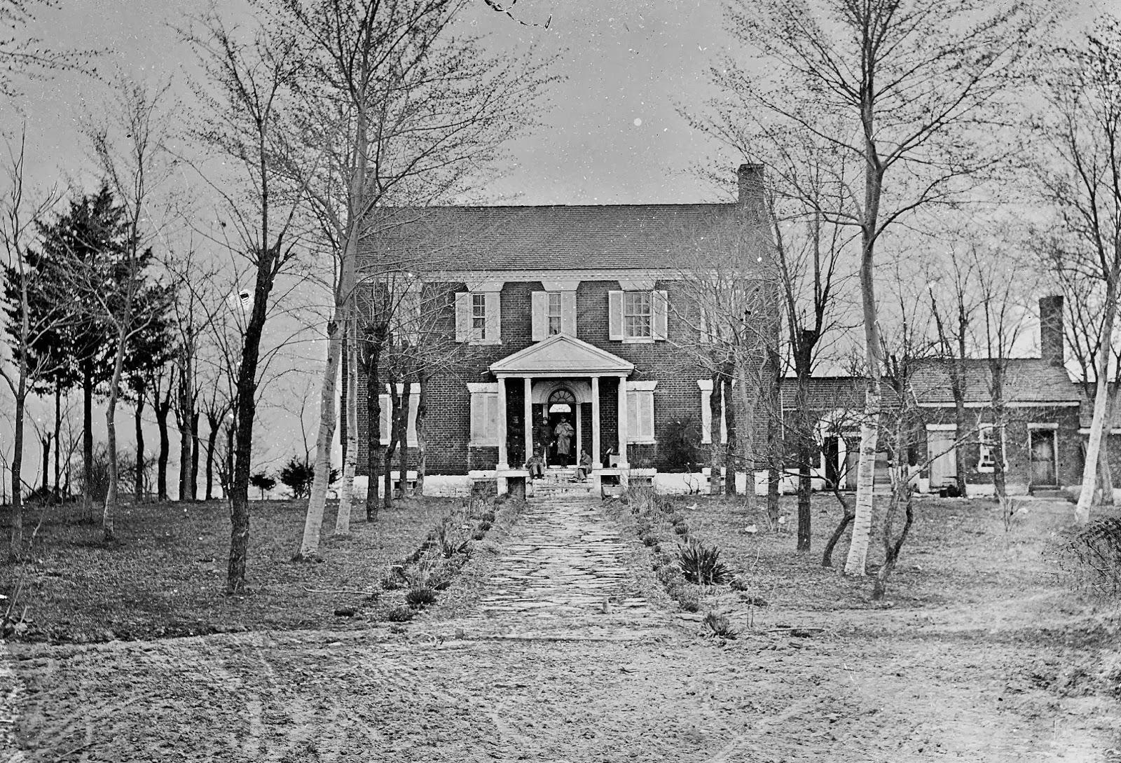
Photo by George N. Barnard, March 1862, during Union occupation,
seen from the original "coach circle". Notice the kitchen wing at right.

August 24, 2013

Detail from the Barnard photograph, March 1862. Union soldiers are
gathered on the porch. General Irvin McDowell made his headquarters
at Liberia in May 1862. The next month, President Lincoln and Secretary
of War Stanton visited the general there. General Daniel E. Sickles was
also temporarily headquartered here in November 1862.

August 24, 2013. Your blog host established temporary headquarters
at Liberia during a living history encampment on the grounds.

This image is said to be the earliest photograph of Liberia,
taken sometime in 1861, by Captain Andrew J. Russell.

Similar view, August 24, 2013

From 1888 to 1947, Liberia was owned by Robert Portner and was the headquarters
of his dairy business, but not his personal residence. An interior view above, from 1936.
Historic American Building Survey

August 24, 2013

Central hallway, 1936, Portner Dairy Farm.
Historic American Building Survey

August 24, 2013

1936, Portner Dairy Farm. By this time the estate was 329 acres.
The home served as the residence of the dairy farm manager.
Historic American Building Survey

Similar view, August 24, 2013.
The house and property are now under management of the
Manassas Museum System, after being donated by the Breedens,
the last family to occupy the house as a personal residence.
It is currently under restoration.
Tuesday, October 8, 2013
Out-of-the-way History in Manassas Park, Virginia. "Yellow Hospital": Then and Now.
The structure had nearly fallen to ruin by the 1970's, but was saved by the local Women's Club, recognizing the importance of its preservation. Now owned by the City of Manassas Park, restoration work will continue when funding permits. The house is surrounded now by offices of Prince William County Schools. The physical address is 8220 Conner Drive, Manassas, VA 20111, near Osbourn Park High School.
Click images for larger viewing.


Friday, October 4, 2013
Smithsonian Civil War - Inside the National Collection: Book Review
Smithsonian Civil War is impressive from the beginning for its sheer weight and design. Beautifully crafted in a manner that reminded me of the early books published by American Heritage, such as Bruce Catton's two volume, Picture History of the Civil War, one of the highlights of my childhood that spawned a lifelong obsession with the period. Inside, the crispness of the images jumps out at the reader. After all, the images are what it's all about, the impressive national treasures that are displayed within. Great care was taken in photographing the pieces selected, displayed in 150 treatments, like chapters, sometimes with multiple items. This volume constitutes a virtual museum in a 368 page book.


Author: Smithsonian Institution; Edited by Neil Kagan; Foreword by Jon MeachamISBN 13: 978-1-58834-389-5ISBN 10: 1588343898

There is so much to absorb that selecting sample images for this review was a near impossible task. Solving that problem came about by randomly opening to a page and going with what it revealed. There could be no losers. Every item chosen is an outstanding relic of the era. In many ways this volume is also reminiscent of the Time/Life, Echoes of Glory set from 1991. But have no fear, the Smithsonian presentation is not a repetition of the same old stuff. Without a doubt, this book will provide hours of initial entertainment and years of continued reference. Any student of the American Civil War, be they novice or lifelong reader, will be delighted in receiving this unique record of the four years that defined us. I highly recommend putting it on Santa's list for any young history buff. This is the kind of work that makes an impression on a budding historian, and they will be so much more impressed by the physical nature of a hardcover book rather than the trendy ebooks out there. The accompanying text is well written and succinct, providing a non-overbearing explanation of the artifacts that will inspire further research, and that is the mark of any great effort such as this. The chronologic flow in presentation tells the story of the causes and ultimate effects of a national tragedy. The Smithsonian Editorial Committee has done a fantastic job in honoring the Sesquicentennial observance of the American Civil War.


Author: Smithsonian Institution; Edited by Neil Kagan; Foreword by Jon MeachamISBN 13: 978-1-58834-389-5ISBN 10: 1588343898
| Hardcover Price: $40.00 |
Wednesday, October 2, 2013
Minor's Hill Signal Tower - Suggested Then and Now
Notice: The correct location of this house has been found.
A follow-up on the date, and location of General McClellan's visit with General Morell on Minor's Hill. According to D. Mark Katz's, Witness To An Era, The Life and Photography of Alexander Gardner, the group portrait of the General-in-Chief and accompanying officers, was copyrighted by Matthew Brady on January 6, 1862. This makes the date the image was made somewhere in the area of three months earlier than initially suspected. Katz's information was derived from the United States Copyright Book, 1861-1868, achieved in the Library of Congress. As for the precise location of the tower, I have still not had time to put boots on the ground, but based on USGS topographic maps, this is the physical summit of Minor's Hill. Logic would put the tower on or near the modern house at center of the following image from Google Earth. A detailed search of land records may provide a plat detailing the position of structures on the original layout of the property. Compare the long shot with the full view of the tower, and this looks promising. Updated research shows location to be around 430 yards from the suggested location seen here. Go to the July 24, 2016 posting for correct location. For all intents and purposes, this is the neighborhood today. Previous posts here and here.
From this position, Confederate activities could be observed to the west and slightly southwest around Fairfax, roughly 9 miles away, Centreville at 15 miles and Manassas at 21 miles.

The above suggested location was proven incorrect in July 2016
by blog reader Stephen Masters.
by blog reader Stephen Masters.
The correct site is around 430 yards to the slight northwest of this intersection.

Thursday, September 26, 2013
NOT Lincoln at Gettysburg: One More Clue
Click on these images for larger viewing.
After another day of continued debate and further scrutiny, I will offer one more item that I think will help settle this. Let's look once more at the Gardner image that Christopher Oakley suggests shows Lincoln, seated, in his top hat. My post yesterday points out that this "Lincoln" is seated behind and to the left of the center stage where it is reasonable to assume the POTUS would be seated. I have indicated Oakley's "Lincoln" with the big red "O". Move your eyes up and to the left. I have placed a white arrow pointing down to a man standing on a higher elevation, wearing what is a more casual slouch style hat, compared to those seated and to his front in top hats. Make note of the top hat figure directly to his front. Also note the higher figures to his rear and right.

Below, I have enlarged the slouch hat man a little more. His top hat wearing neighbor is partially cropped out of the view, to his left. Note a white shape that suggests an exposed shirt collar below the profile.

Moving on now to a detail from the image taken from the approximate front of the speakers' platform by another photographer. I have placed a white arrow pointing down toward an elevated figure in a slouch hat and a largely exposed white shirt collar. Partially concealing him in front is one of numerous men wearing ceremonial sashes. He has taken his hat off at this time. I suggest he is the same man in the previous Gardner view that was to the front left of the slouch hat man. Notice to the right, seated, is one of what is a cluster of men in top hats, more clearly seen in the fuller detail below this one. I am suggesting that this cluster of top hatted men is the grouping seen in the Gardner image where the "Lincoln" is supposed to be seated. By seeing these two images, known to be taken at approximately 60 degrees from each other, we can place the slightly elevated figures in relation to the seated figures and in the larger detail, see where Lincoln truly is seated, further off to the left and in what would be the center of the platform.

Below, the larger detail shows the cluster of men in top hats, off to the right, with our elevated friends rising to the left, and gradually sloping back down, all the while essentially forming a semi-circle around the President who is seated, bareheaded, to the left of center, above the heads of the audience in front.

And in closing, to supply a few requests for some indication of the camera positions in relation to the speakers' platform, here is an aerial view with red lines from each camera position pointing directly to the platform. The yellow line indicates the approximate 78 yard separation between the two photographers.
The camera positions are placed according to the map created by William Frassanito in his book, Early Photography at Gettysburg, page 139, and are approximates.

Wednesday, September 25, 2013
The Clue That Should End the "Lincoln at Gettysburg" Question
As with all images on this blog, please click them for larger, detailed viewing.
Yesterday's hoopla regarding the supposed discovery of a new Lincoln image at Gettysburg is continuing to cause a stir along the media and blogosphere. One consideration that I realized I left out of my prior analysis, was the simple fact that Christopher Oakley's "Lincoln" is sitting behind other attendees, rather than sitting in the prominent front row where one would have to assume the President of the United States would justifiably be seated. Below, I present as I did yesterday, a detailed enlargement of the Alexander Gardner image, annotated with a red "O" over the head of Oakley's "Lincoln". The red X is the point of focus for the encircling spectators.

An even further enlargement, below, shows quite clearly that the Oakley "Lincoln" is seated with head meekly bowed, at least one row behind what is the apparent stage front, mixed in with other similarly dressed men, all in tall hats and dark coats. Why would the POTUS be seated there in a subservient position? He would not.

Now, let us look again at the other image taken that day by another photographer, from another angle, perhaps roughly 61 degrees, and about 78 yards slightly northeast from Gardner's camera platform. These estimates are based on mapping created by William Frassanito in his book, Early Photography at Gettysburg, page 139.
Lincoln is clearly visible, and that has been long established. I have placed an "L" over his head for clarity. Notice if you will, to the far right of the cropped image, there are numerous rows of seated men wearing top hats, behind the two bareheaded gentlemen and a young boy. I submit that it is this grouping of men in hats that we are seeing in Gardner's images, elevated and behind the front row where the President is seated.

Done.
Subscribe to:
Posts (Atom)