Battlefield Guide Services

Thursday, February 28, 2013

Debunking the CCWP's, Lincoln at Gettysburg Discovery

     Updated. See additional material at end of post.
     On November 16, 2007, USA Today ran a front page article proclaiming that a member of the Center for Civil War Photography had discovered two new images of President Abraham Lincoln at Gettysburg. Stating that the "discovery" doubled the known images of the President on the day he delivered his Gettysburg Address, the article, and subsequent press release from the CCWP, described how the President could be seen riding through the crowd, saluting soldiers with his left hand. Upon seeing the images, acclaimed Lincoln scholar, Harold Holzer is quoted, "All I can say is, Wow! Unbelievable." President of the CCWP, Bob Zeller proclaimed, "I think it’s one of the most significant Civil War photographic discoveries in quite some time. It’s as if we can ask a Civil War photographer to go back out on the field and take just a couple of more shots of the greatest president in American history."
     But, what do these photographs, taken as stereo pairs, actually show? The images are derived from glass negatives taken by Alexander Gardner, and are available for inspection via the Library of Congress website's, Prints and Photographs Online Catalog. Three exposures from virtually the same camera position survive today. Gardner's camera was either purposely, or accidentally moved to the right in the third image of the sequence. The timing of the three images is easily determined by the change in location of various individuals, and a horse-drawn vehicle in the first and second, as well as by the clear movement of a shadow along the west wall of the Evergreen Cemetery gate. Below are the left-hand portion of the three stereo negatives, in order of their creation. Click on these and all images presented, for a larger view.


     Below, the horizon details of each, in the same sequence, anchoring the fixed camera position. Stationary objects at left, and right serve as markers. Remember, for the third exposure, Gardner's camera is slightly moved, but the dominant features maintain their relative position.

 The third is the telling image. It appears the soldiers have decided to get off their feet in some cases.
     The next three detail views demonstrate the shadowing cast of the wall of the gate house. The first is faint due to apparent cloud cover.
      In the second exposure, the sun has emerged to cast a very strong shadow, but this image was taken within a very short time after the first. Minutes? Note that some of the soldiers have now stuck their bayonets into the ground. Not at attention, but at rest.
      In the third exposure, the sun has clearly risen, and the shadow has moved like a sun dial across the face of the wall. Unfortunately, there has been a structural addition built on this wall, which will today, obscure the shadowing seen here, thus making difficult an effort to calculate the exact time it was taken on the anniversary date in November. The soldiers have now stacked their arms.
     Below, closer detail of the three images, again presented in the order taken. In all three I have marked certain features. At left is a tree which I have marked as "T". At right, a grouping of spectators that maintain their relative position, marked as "3". The figure that was said to be the "saluting" Lincoln, is marked by "1", and a horse-drawn carriage, driving toward the right, is marked as "2". This first image here, was incorrectly considered to be the second image by the CCWP.
    The true second exposure below, made probably within a minute of the previous image, shows that the "Lincoln" figure, "1", has actually not moved from his previous position, yet the horse-drawn carriage, "2",  has advanced closer to the group of spectators, "3". The carriage drivers are easily discernible. The foreground figures are getting settled on their mounts. Nobody seems to be focused on the figure said to be Lincoln. The specators at right appear to be more interested in what is happening further to the right (their left), on the speaker's platform.
    And, in the third exposure, taken after a short time has elapsed, (perhaps ten or fifteen minutes?)shows what may very likely be the same "Lincoln" figure, possibly obscured by another mounted figure, still marked by "1". The horse-drawn carriage, "2", has parked and there is an individual seated on its hard top roof. The driver is still seated. The group of spectators at far right have maintained their spots, looking toward the speaker's platform, and the tree at far left has of course stood vigilant throughout.
     Additional thoughts regarding the supposed "Lincoln" are, A. Why would the President salute with his left hand? He wouldn't. B. How is he passing through the crowd as suggested by the CCWP? He isn't. The figure is standing in one spot. It is the horse drawn carriage that has moved past the figure. And C. If this is the President, why are most of the people in the crowd, especially the military, just loitering about? In the third image, the soldiers have stacked arms, and no one seems to be leaving the site, although it was suggested by the CCWP that the President was on the move, facing to the left even. Exiting? The entourage should be arriving from left to right. Note: The speaker's platform is to the right of center, and just left of a large tent, in the full frame images, appearing like a small hill. What this series does show is a very bored crowd waiting for something to happen. No one is standing at attention. Could it be that Lincoln has not yet arrived, and the crowd is waiting for it to happen? Or, is he and the other esteemed guests already gathered and the soldiers in the crowd are preparing for a long period of oration? Edward Everett spoke for over two hour prior to the president's few minutes. If we can firmly determine the time, based on the moving shadow of the sun on November 19, we may have an easier time figuring at what point in the dedication ceremony these images were taken.

And one additional thought to this consideration: Why is the focus of the crowd in this detail below, placed on the apparent speaker's platform, still, if the President has either not yet arrived or is leaving, based on the CCWP presentation? This detail is extracted from the very same image that provides the so called "saluting" Lincoln, the first image in the series. And, you will see, at now far left, the group of spectators that I had previously tagged with a "3", staring toward the center, along with everyone else it now seems. If the President of the United States was far off to the left from this view, why wouldn't the attention be focused on that fact? No, I have to say, Lincoln is already on the speaker's platform in this and the other two images. The third image, based on the absolute look of boredom and the stacked arms of the soldiers, gives me reason to believe that it is during Mr. Everett's agonizingly long speech.

Monday, February 25, 2013

Gettysburg's Harvest of Death : "Field Where General Reynolds Fell" - the details

     This is of course a continuation of my study of the Gettysburg, after battle images which are now collectively known as the "Harvest of Death Series" as they are of the same bodies of Union dead, photographed from near opposite directions, a fact originally published by William A. Frassanito in 1975's groundbreaking work, Gettysburg A Journey In Time. "Harvest of Death" is derived from the caption given by Alexander Gardner to the image looking southward, examined in previous posts here on this blog. See the more detailed and all inclusive posting by clicking here.
     Below is the left side of the O'Sullivan stereo pair looking slightly northeast, annotated to compare locations of four key horizon elements in the matching of my then and now images. (A) being the Thompson House, aka "Lee's Headquarters" (B) the faint trace of the Chambersburg Pike, just below the letter, and seeming to jut out from behind the foliage of the large tree. This detail is slightly crisper in the Gibson exposure of nearly the same angle. (C) a lone tree that appears to sit on the south side of the Pike. (D) the extreme left edge of the open field on the north side of the unfinished Oak Ridge Railroad Cut, seen as a whiter strip between the darker trees, and the perceptibly darker field on the south side of the cut.
Click on this, and all images in this post, for larger viewing.

    Below, the approximate same position today with the main elements of the O'Sullivan exposure superimposed over top, and the same four key horizon elements annotated. The open field for (D) is today obscured by mature tree growth on both the former field and the south edge of the rail cut, as well as by the buildings of the twentieth century motel, "Quality Inn at General Lee's Headquarters."
Below, an artificially created demonstration of the effect of the lack of "depth of field"
on objects in the distance when focus is on the foreground subject matter. Any
suggestion that "fence posts" should be visible along the Pike is ridiculous for this image.
An additional complaint, by detractors of this material, suggests that the Thompson House
 should appears darker in the period image if it is indeed the Thompson House.
 This gray scale copy of the above color image demonstrates that that is also an absurd assertion.
Below, the left half of Gibson's stereo pair with (B) annotating the
Chambersburg Pike below it, emerging from behind the large tree's foliage. Very
 possible indications of fence posts are visible here under magnification. This
 image has slightly more "depth of field", and is a bit stronger in contrast than O'Sullivan's,
but it is still not as detailed as other images taken elsewhere around Gettysburg in 1863.

     The sad thing about the ongoing debate with detractors on this subject matter is that this location was initially suggested by a man named John Stewart in 1999 and dismissed by William Frassanito. Stewart's comparison was made at too great a distance from the Chambersburg Pike and an overlay comparison appeared spurious. In 2011, Scott Hartwig independently suggested the same near location, but was again plagued by a miscalculation of the distance between where the bodies were to the Chambersburg Pike. My examinations, first begun in late 2011, were to be made as supporting material for Mr. Hartwig's study, and focused on the previously undetected Thompson House in the right distance of the O'Sullivan exposure. This was my initial contribution to the brew. It was at this time that Garry Adelman of the self-styled "Center for Civil War Photography" pounced heavily on against this suggestion (seemingly out of rapt devotion to the opinion of Frassanito), and produced a thirteen part series on the now dormant "Gettysburg Daily" blog site. When dealing with my material, Garry focused heavily on my earliest, and quickly obsolete postings, filming in February, videos that would not appear on Gettysburg Daily until May. My research had remained fluid and was openly posted during that time on this blog,  and I was continually adjusting my location on the field to correct what remained a somewhat elusive camera position for Gardner and crew, although I was convinced that it was in the immediate area. In the late summer of 2012, I had at last found what proved to be the site that clearly worked in either direction for both "The Field Where Reynolds Fell" and "A Harvest of Death". All along, the same general view as first suggested by John Stewart, but in the end, nearly 200 yards further north along the park road, Reynolds Avenue, and in the end roughly 123 yards west of my initial focus.
     Mr. Adelman continues to the present day to deny that the location of these historically important images has been found, claiming them as still "unknown" and open to discovery.

     Let me state that I hold the Center for Civil War Photography in high regard, and it is composed of a great group of warm and generous people, all with a focused passion for the subject matter. The work they do is invaluable and there annual seminars are inspirational. Garry Adelman, as a founding member of that group, and an indefatigable historian, is a genuine pleasure to associate with and his exuberant manner is endearing to all who meet him. We are just divided on this matter at hand. I look forward to the day we can agree on it. Right now it's like history held hostage.

Addition:

   Below, based on a suggestion after the initial publishing of this post, are approximate then and now of what I suggest could very likely be fence posts along the Chambersburg Pike from the Gibson image and my detail overlay from above. The angled arrow points to the area that juts out from the foliage of the large tree, a very similar appearance today. 


     There is also worth noting, a thin, dark line that further accents the division of the two sides of the railroad cut, probably a shadow effect of the south side against the north side, thus the line delineates the actual "ditch" of the cut. This view also makes significantly clearer the wood line on the far edge of the lighter toned field, which is today covered with mature trees. The south side of the cut is today, as previously stated, now obscured by trees and the motel buildings.


Monday, February 18, 2013

The Bloody Angle Bridge - GONE

     For those who know the Spotsylvania battlefield well, the following picture might be a surprise if you haven't been recently. The wood bridge that spanned the Confederate works at the Bloody Angle for many years has been removed in the latest of the long planned efforts at scene restoration and interpretive improvements. Presently it gives new visitors the impression it is a trail across the works. My first observation of a random tourist witnessed a man on the south side of the trench, as seen here, stopping at the area of the concrete "stump" block, turning north, seeing the monuments and proceeding across to read them in detail, then proceeding along the trail on the north side of the works to the new bridge built in June and July 2010. Hopefully it will take only a brief time to get grass growing back over the area covered by the bridge for years. That, and the additional placement of a "Please Keep Off The Trenches" sign will, or should, do the trick. Hopefully.
 
     As seen below, the view on the approach from the parking lot is pleasantly uninterrupted with the bridge gone. It does however lack immediate interpretive signage to inform the uninitiated that they are in fact at the "Bloody Angle", one of America's most important landscape features.
 
     The view below shows the former bridge site from the monuments, looking southward. Note the  remaining stones that held the structure off the ground on the north side. I would imagine the stones will be removed in the new future. Perhaps the work crew was hesitant to remove them initially, not knowing if they had a cultural resource importance.
     Now, the thing that still puzzles me with the new signs is their distance from the actual "Bloody Angle" and site of the fabled 22" Oak Tree. The monuments are essentially in front of the Bloody Angle but nothing makes this clear from the sign, nor does the aforementioned concrete "stump" block get any mention. There is a photograph showing the original stump in the Smithsonian, but there is nothing that indicates that the concrete block stands at its site based on oral tradition and a pre-park stake hammered in the ground on the same spot.
Below, a 1921 photograph of Lynwood Landrum, standing next to the stump site. The 15th New Jersey monument is seen at left, surrounded by a long removed iron fence.
From the author's collection.
 
The placement of an additional sign, perhaps similar to this one, may help deter visitors from walking over the Bloody Angle.
For now the path looks inviting and intentional, as seen a few days ago, below.
The view below is from the early 1930s when the C.C.C. was building the park road, now removed.
Note the extreme grade that was cut to allow for building of the road with compacted crushed rock. 
Another view from the 1930s shows the Ranger Contact station that stood at the Bloody Angle up until the Civil War Centennial when the current interpretive "shelter" was built near the park entrance on Grant Drive at Brock Road. The concrete "stump" block is at left of front center. This and the previous image are from the archives of the Fredericksburg and Spotsylvania National Military Park.

Friday, January 25, 2013

The John Minor Botts Home For Sale. "Auburn", built circa 1855.

Do you have a spare four million bucks handy? Love history?

This morning I received an email from a good friend that contained the following link: http://www.farmandestate.net/Property-AUBURN_FARM

"Auburn", the home of staunch Unionist John Minor Botts near Culpeper, Virginia, is up for grabs to those with deep pockets. Botts won the home in a poker game in December 1862, and it was eventually well documented by photographer Timothy O'Sullivan in September 1863. Most enthusiasts of Civil War history are familiar with the following image of Botts and members of his family on the front porch of the house. It is probable that they are his three daughters, Rosalie, Mary Jane, and Isabella, but the older woman can not be his wife, Mary Whiting Blair, since some sources indicate she died on or before March 22, 1862. Her burial record at Shockoe Hill Cemetery in Richmond, Virginia, however provides a burial date of February 5, 1841, which may suggest she died shortly after the birth of her last child, Isabella, born February 3, 1841, with another source suggesting Mary's death date as February 12, 1841. The woman is then most likely Margaret M. Blair, Mary's sister, as she appears in the 1850 and 1860 census records as living with Botts and his children. The standing man next to Botts may be his son, Beverly Blair Botts, the only one of four sons that were living by the time of this image. Click on this, and all images, for larger viewing.
 Botts had been jailed in March 1862 by the Confederate government for his unflinching anti-secession views, and held for eight weeks in solitary confinement. He was released only after he swore to hold his tongue from additional anti-Confederate rhetoric. He was again briefly detained by order of General J.E.B. Stuart in October of 1863, one month after most of these photographs were taken, for supposedly entertaining Union officers at his dinner table.
 Although an unwavering Unionist, Botts was still a slave owner. Three of his slaves had run away to Union camps in the area, and when Botts attempted to recover them he was firmly rebuked, being told that his former "property" had become "free" upon entering the Union encampment.
 The vast estate of "Auburn" was host to three "Grand Reviews" held by both armies, the first by Confederate General Stuart on June 8, 1863, the day before the battle of Brandy Station. Two more would be held by Union forces under General Meade in April 1864, and General Grant in May, just prior to the launch of the 1864 Spring Campaign. The above winter view was taken by a currently "unknown" photographer.
A stereo negative of the home, by O'Sullivan, taken September 1863.
The cropping seen above, of the previous stereo image, shows the comfortable Botts family under protective guard of Union soldiers, perhaps the incident that provoked Stuart to arrest Botts the next month. Below, an enlargement from another view, with two women in comfortable association with a Union junior officer two months after the northern victory at Gettysburg.
Another interesting enlargement below provides a glimpse, perhaps, of one of the Botts' chattel, standing meekly, but at the ready, behind the column at center. Freedom was not far off for her. 
 
All images presented here are from the collection of the Library of Congress.


Thursday, December 13, 2012

Scenes of Fredericksburg's 150th Anniversary Reenactment

     On Saturday, December 8, 2012, the City of Fredericksburg once again witnessed the sites and sounds of battle. Union forces crossing the Rappahannock River on pontoon bridges met with staunch resistance just as had occurred one hundred and fifty years before.  
 
Mock urban warfare erupted in the streets.

Blue clad forces pressed on.


     But, as in 1862, the ordeal would end in a costly "slaughter", on the streets and at the foot of Marye's Heights, in front of a simple stone wall, along an infamous Sunken Road. Alas, when the smoke cleared, these "honored dead" arose to rejoin family and friends, and live another day, ending a fitting and proper "commemoration" of the Sesquicentennial anniversary.

All photographs copyright 2012 by John F. Cummings III


Friday, October 12, 2012

Gettysburg's Harvest of Death - The Conclusion

     Next month will mark the one year anniversary since I first began posting my findings regarding the most elusive of photographs taken at Gettysburg. In May of 2011, Scott Hartwig, the supervisory historian with the Gettysburg National Military Park, first brought public attention to this location on the Park's Blog. Personally, I was impressed with his presentation and in-depth research. Scott focused on one of two images looking north east, the "Gibson" stereo view. Curious, I looked at the somewhat broader view taken by Timothy O'Sullivan, and immediately made note that it revealed, in the upper right corner, the Thompson House, known also more famously as "Lee's Headquarters." That November, I took a trip to Gettysburg for the Remembrance Day Commemoration, and set aside some time to visit Scott's site and provide additional support by photographing a modern view that included the house. I quickly saw that Scott's camera location was simply too far away to be precise to the 1863 images, however, he was certainly looking at the correct overall features. Unbeknownst to me at the time, Garry Adelman had challenged Scott's findings that had been published in the October 2011 issue of Civil War Times Magazine. Adelman's challenge appeared as a letter to the editor in the same magazine's December issue, and declared the location "unsolved" and still open for discovery.
     Upon returning home with my findings in November, I began what would be my first of a series of posts that sought to add further support to the work of Scott Hartwig. My assertion that the Thompson House was visible, and thus supported Scott's work, was quickly shot down by Mr. Adelman, and a form letter of sorts made its way around Civil War web addresses, titled
 "GARRY ADELMAN’S PLEA FOR PATIENCE WITH ALL THINGS HARVEST OF DEATH".
     This began my debate with Garry that eventually inspired his creating a thirteen episode presentation on the Gettysburg Daily Blog, wherein Garry and his associate Tim Smith took to task numerous people's theories as to the now notorious "Harvest of Death" location. The series wrapped up with several installments devoted to refuting Mr. Hartwig's and my examinations. I continued my research, looking further into details the images held, and all the while, with admitted misturns along the way, I made continued posts to this blog site, adding details that added up to supporting the location as the actual site. My one problem though continued to be the distance that I live from Gettysburg, requiring at least six hours of travel time in a day for each visit and no luxury of affording overnight accommodations. Thus I would bring my work home each time and see how the day's efforts fit. Gradually, over several return visits, I made my way along the landscape and arrived at the location that brought all the pieces together, although it is approximately 123 yards west of my initial, heavy concentration of study. It is also, as I had detected, nearly 190 yards closer to the Chambersburg Road than Scott Hartwig's estimation. However, this is what it takes to fine tune something that has been plagued from the outset by 1863 images that are far from sharp in detail, but still full of revealing information.
     Thus I present what will rest as the final, and correct, installment of my blog posting regarding these photographs. The challenge of having to adjust by a foot or yard, left or right, up or down or tilted, and in any direction is unnecessary and unwelcome, as this posting presents the final clue that makes this the true location, on the battlefield of July 1, 1863, and provides the source of Alexander Gardner's inclusion of General John Reynolds in the title, "Field Where General Reynolds Fell". The monument to this incident stands at a short 100 yards or so to the west of where these bodies had fallen. 
     The final clue rests in the wooded horizon line in both O'Sullivan's and Gibson's images: 
 
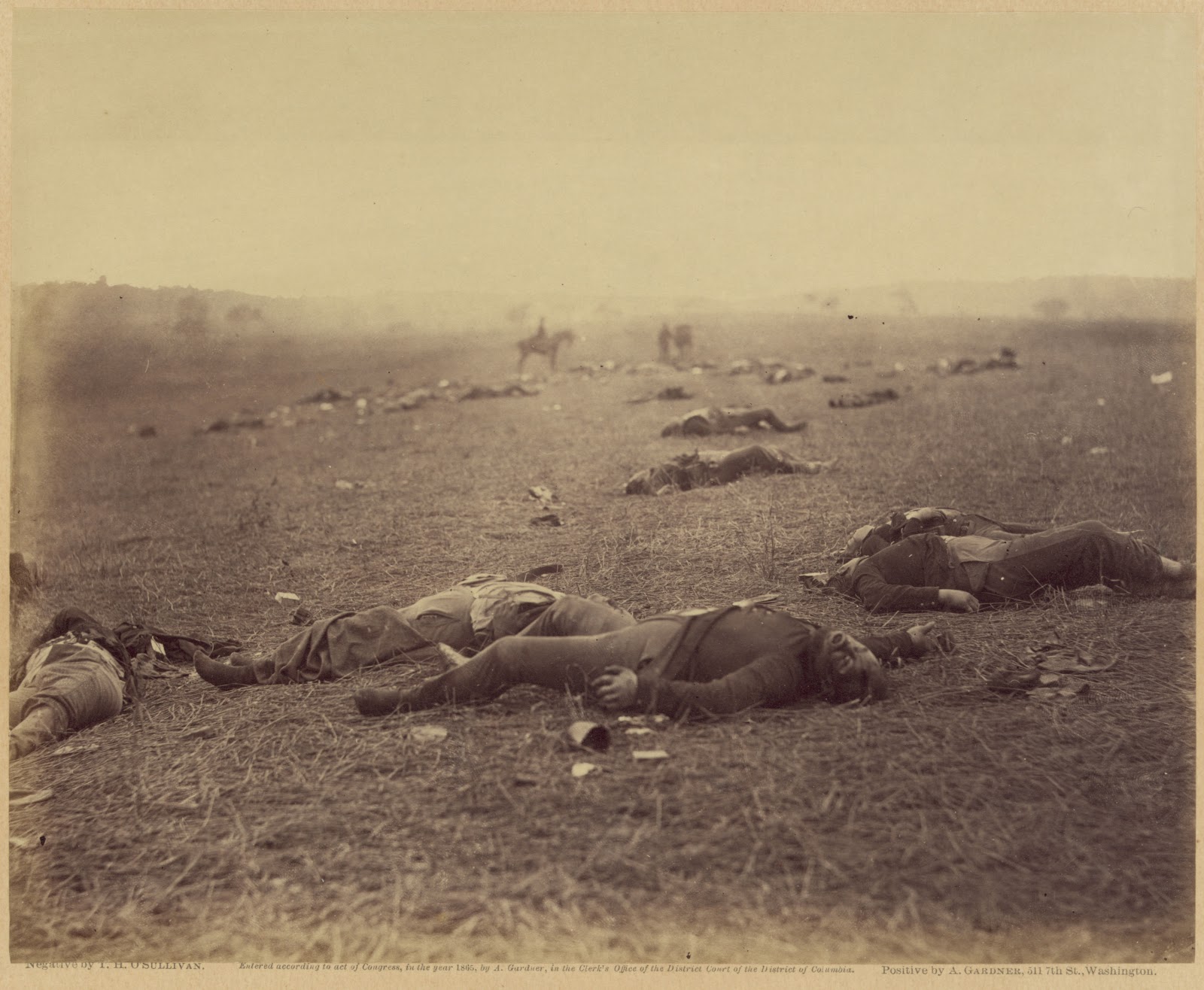
"The Field Where General Reynolds Fell", from O'Sullivan's stereo negative, similar
 to the full plate version that appears in the 1866, Photographic Sketch Book of the War.
The camera is looking at approximately 64 degrees NE on center. The Thompson House
is at upper right. The Chambersburg Pike runs, barely perceptible, along the center of the rise. 

 The approximate same view today, looking roughly 64 degrees North East.
Note the clearer line of the Chambersburg Road and the Thompson House.
 Also, a strip of trees obscures the southern edge of the rail cut, along with
 a motel, blunting the visible edge of the 1863 views.
Aerial map placing approximate location of bodies, and field
of view for both camera directions. Other features within the
north east direction of O'Sullivan's photograph are annotated.
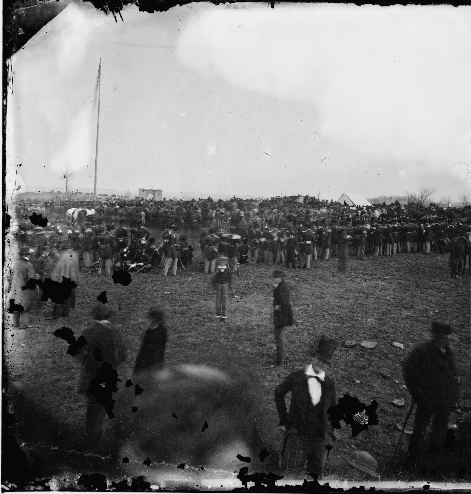
One side of Gibson's stereo view with the Union burial crew.
Note the sliding scale effect created by the crew, illustrating how the
terrain beyond drops and rises toward the horizon line and woods.
Not attempted to stand on the precise location of the burial crew
members, nor the exact angle of Gibson's camera,  the digitally
 duplicated figure at center does demonstrate the "sliding scale"
 effect against the dropping and rising background, toward the rail cut today.
An enhanced section of Gibson's stereo view. Note the difference
in color of the rising slope (south side of cut), and the continuation
beyond on the north side of the cut. The darker, wood's edge beyond,
begins at roughly 297 ft from the south side of the cut, coming to a
corner and turning nearly due south at the right edge of this detail.
 
A further enlargement in gray scale, with annotations of the space.
 Click on this, and any image, for larger viewing
The yellow line, marked with the blue arrow at center, indicates
the approximate 297 ft opening that existed in 1863, from the south
 side of the rail cut, to the wood's edge. The land rises nearly fourteen
 feet inside that gap, creating the space we see above as a lighter gray band.
  This feature can not be found elsewhere on the battlefield.
Looking roughly 121 degrees south east from the rail cut crossover.
Note the gradual rise of the ridge to the left of the rail cut.  
 Looking roughly 306 degrees north west along the rail cut, behind
the Thompson house site, aka Lee's Headquarters.
"A Harvest of Death" from Gardner's Sketchbook. Same bodies, but viewed
  from the opposite side, and a 135 degree, clockwise turn to the south.

The approximate same view today, looking roughly 200 degrees South West. 
For questions regarding the horizon line, see this previous post on the subject.
A section of the 1895 "Cope" map showing the area around
Reynold's Woods and the Thompson House. I have placed a red
 X on the approximate location of the bodies for both 1863 images.
 
 
My thanks go out to my friend James Anderson for his assistance during my investigative trips.