Battlefield Guide Services

Friday, January 25, 2013

The John Minor Botts Home For Sale. "Auburn", built circa 1855.

Do you have a spare four million bucks handy? Love history?

This morning I received an email from a good friend that contained the following link: http://www.farmandestate.net/Property-AUBURN_FARM

"Auburn", the home of staunch Unionist John Minor Botts near Culpeper, Virginia, is up for grabs to those with deep pockets. Botts won the home in a poker game in December 1862, and it was eventually well documented by photographer Timothy O'Sullivan in September 1863. Most enthusiasts of Civil War history are familiar with the following image of Botts and members of his family on the front porch of the house. It is probable that they are his three daughters, Rosalie, Mary Jane, and Isabella, but the older woman can not be his wife, Mary Whiting Blair, since some sources indicate she died on or before March 22, 1862. Her burial record at Shockoe Hill Cemetery in Richmond, Virginia, however provides a burial date of February 5, 1841, which may suggest she died shortly after the birth of her last child, Isabella, born February 3, 1841, with another source suggesting Mary's death date as February 12, 1841. The woman is then most likely Margaret M. Blair, Mary's sister, as she appears in the 1850 and 1860 census records as living with Botts and his children. The standing man next to Botts may be his son, Beverly Blair Botts, the only one of four sons that were living by the time of this image. Click on this, and all images, for larger viewing.
 Botts had been jailed in March 1862 by the Confederate government for his unflinching anti-secession views, and held for eight weeks in solitary confinement. He was released only after he swore to hold his tongue from additional anti-Confederate rhetoric. He was again briefly detained by order of General J.E.B. Stuart in October of 1863, one month after most of these photographs were taken, for supposedly entertaining Union officers at his dinner table.
 Although an unwavering Unionist, Botts was still a slave owner. Three of his slaves had run away to Union camps in the area, and when Botts attempted to recover them he was firmly rebuked, being told that his former "property" had become "free" upon entering the Union encampment.
 The vast estate of "Auburn" was host to three "Grand Reviews" held by both armies, the first by Confederate General Stuart on June 8, 1863, the day before the battle of Brandy Station. Two more would be held by Union forces under General Meade in April 1864, and General Grant in May, just prior to the launch of the 1864 Spring Campaign. The above winter view was taken by a currently "unknown" photographer.
A stereo negative of the home, by O'Sullivan, taken September 1863.
The cropping seen above, of the previous stereo image, shows the comfortable Botts family under protective guard of Union soldiers, perhaps the incident that provoked Stuart to arrest Botts the next month. Below, an enlargement from another view, with two women in comfortable association with a Union junior officer two months after the northern victory at Gettysburg.
Another interesting enlargement below provides a glimpse, perhaps, of one of the Botts' chattel, standing meekly, but at the ready, behind the column at center. Freedom was not far off for her. 
 
All images presented here are from the collection of the Library of Congress.


Thursday, December 13, 2012

Scenes of Fredericksburg's 150th Anniversary Reenactment

     On Saturday, December 8, 2012, the City of Fredericksburg once again witnessed the sites and sounds of battle. Union forces crossing the Rappahannock River on pontoon bridges met with staunch resistance just as had occurred one hundred and fifty years before.  
 
Mock urban warfare erupted in the streets.

Blue clad forces pressed on.


     But, as in 1862, the ordeal would end in a costly "slaughter", on the streets and at the foot of Marye's Heights, in front of a simple stone wall, along an infamous Sunken Road. Alas, when the smoke cleared, these "honored dead" arose to rejoin family and friends, and live another day, ending a fitting and proper "commemoration" of the Sesquicentennial anniversary.

All photographs copyright 2012 by John F. Cummings III


Friday, October 12, 2012

Gettysburg's Harvest of Death - The Conclusion

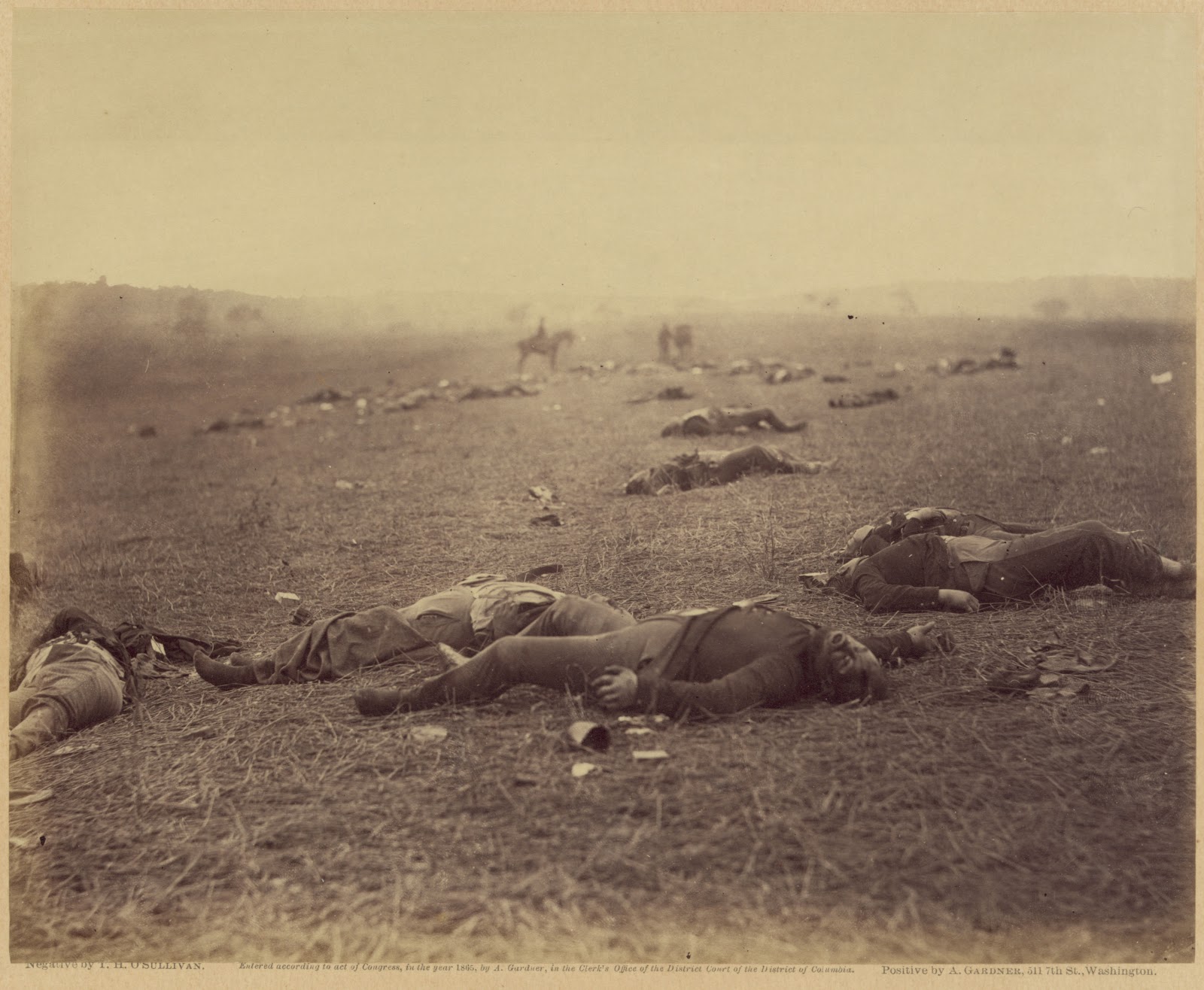
     Next month will mark the one year anniversary since I first began posting my findings regarding the most elusive of photographs taken at Gettysburg. In May of 2011, Scott Hartwig, the supervisory historian with the Gettysburg National Military Park, first brought public attention to this location on the Park's Blog. Personally, I was impressed with his presentation and in-depth research. Scott focused on one of two images looking north east, the "Gibson" stereo view. Curious, I looked at the somewhat broader view taken by Timothy O'Sullivan, and immediately made note that it revealed, in the upper right corner, the Thompson House, known also more famously as "Lee's Headquarters." That November, I took a trip to Gettysburg for the Remembrance Day Commemoration, and set aside some time to visit Scott's site and provide additional support by photographing a modern view that included the house. I quickly saw that Scott's camera location was simply too far away to be precise to the 1863 images, however, he was certainly looking at the correct overall features. Unbeknownst to me at the time, Garry Adelman had challenged Scott's findings that had been published in the October 2011 issue of Civil War Times Magazine. Adelman's challenge appeared as a letter to the editor in the same magazine's December issue, and declared the location "unsolved" and still open for discovery.
     Upon returning home with my findings in November, I began what would be my first of a series of posts that sought to add further support to the work of Scott Hartwig. My assertion that the Thompson House was visible, and thus supported Scott's work, was quickly shot down by Mr. Adelman, and a form letter of sorts made its way around Civil War web addresses, titled
 "GARRY ADELMAN’S PLEA FOR PATIENCE WITH ALL THINGS HARVEST OF DEATH".
     This began my debate with Garry that eventually inspired his creating a thirteen episode presentation on the Gettysburg Daily Blog, wherein Garry and his associate Tim Smith took to task numerous people's theories as to the now notorious "Harvest of Death" location. The series wrapped up with several installments devoted to refuting Mr. Hartwig's and my examinations. I continued my research, looking further into details the images held, and all the while, with admitted misturns along the way, I made continued posts to this blog site, adding details that added up to supporting the location as the actual site. My one problem though continued to be the distance that I live from Gettysburg, requiring at least six hours of travel time in a day for each visit and no luxury of affording overnight accommodations. Thus I would bring my work home each time and see how the day's efforts fit. Gradually, over several return visits, I made my way along the landscape and arrived at the location that brought all the pieces together, although it is approximately 123 yards west of my initial, heavy concentration of study. It is also, as I had detected, nearly 190 yards closer to the Chambersburg Road than Scott Hartwig's estimation. However, this is what it takes to fine tune something that has been plagued from the outset by 1863 images that are far from sharp in detail, but still full of revealing information.
     Thus I present what will rest as the final, and correct, installment of my blog posting regarding these photographs. The challenge of having to adjust by a foot or yard, left or right, up or down or tilted, and in any direction is unnecessary and unwelcome, as this posting presents the final clue that makes this the true location, on the battlefield of July 1, 1863, and provides the source of Alexander Gardner's inclusion of General John Reynolds in the title, "Field Where General Reynolds Fell". The monument to this incident stands at a short 100 yards or so to the west of where these bodies had fallen. 
     The final clue rests in the wooded horizon line in both O'Sullivan's and Gibson's images: 
 
"The Field Where General Reynolds Fell", from O'Sullivan's stereo negative, similar
 to the full plate version that appears in the 1866, Photographic Sketch Book of the War.
The camera is looking at approximately 64 degrees NE on center. The Thompson House
is at upper right. The Chambersburg Pike runs, barely perceptible, along the center of the rise. 

 The approximate same view today, looking roughly 64 degrees North East.
Note the clearer line of the Chambersburg Road and the Thompson House.
 Also, a strip of trees obscures the southern edge of the rail cut, along with
 a motel, blunting the visible edge of the 1863 views.
Aerial map placing approximate location of bodies, and field
of view for both camera directions. Other features within the
north east direction of O'Sullivan's photograph are annotated.
One side of Gibson's stereo view with the Union burial crew.
Note the sliding scale effect created by the crew, illustrating how the
terrain beyond drops and rises toward the horizon line and woods.
Not attempted to stand on the precise location of the burial crew
members, nor the exact angle of Gibson's camera,  the digitally
 duplicated figure at center does demonstrate the "sliding scale"
 effect against the dropping and rising background, toward the rail cut today.
An enhanced section of Gibson's stereo view. Note the difference
in color of the rising slope (south side of cut), and the continuation
beyond on the north side of the cut. The darker, wood's edge beyond,
begins at roughly 297 ft from the south side of the cut, coming to a
corner and turning nearly due south at the right edge of this detail.
 
A further enlargement in gray scale, with annotations of the space.
 Click on this, and any image, for larger viewing
The yellow line, marked with the blue arrow at center, indicates
the approximate 297 ft opening that existed in 1863, from the south
 side of the rail cut, to the wood's edge. The land rises nearly fourteen
 feet inside that gap, creating the space we see above as a lighter gray band.
  This feature can not be found elsewhere on the battlefield.
Looking roughly 121 degrees south east from the rail cut crossover.
Note the gradual rise of the ridge to the left of the rail cut.  
 Looking roughly 306 degrees north west along the rail cut, behind
the Thompson house site, aka Lee's Headquarters.
"A Harvest of Death" from Gardner's Sketchbook. Same bodies, but viewed
  from the opposite side, and a 135 degree, clockwise turn to the south.

The approximate same view today, looking roughly 200 degrees South West. 
For questions regarding the horizon line, see this previous post on the subject.
A section of the 1895 "Cope" map showing the area around
Reynold's Woods and the Thompson House. I have placed a red
 X on the approximate location of the bodies for both 1863 images.
 
 
My thanks go out to my friend James Anderson for his assistance during my investigative trips.


Saturday, October 6, 2012

Retraction - Enlargement of Gettysburg Image? Not this time...

     Despite appearances, further scrutiny has shown that this image from Gardner's Photographic Sketch Book of the War, Plate 36, is not an enlarged print of the left half of the stereo negative as seen below it. The error, stated here in the now edited, prior post, was heavily based on the assumption that Gardner and crew would have had to actually change out cameras to produce each format. What is now more clear is that Gardner's "field camera" had to have been fitted with an interchangeable lens board that could switch from the duel stereo lenses, to the single lens for a full plate image on 8" X 10" in contrast to the 4" X 10" of the stereo negatives. This interchangeable camera would have also required a removable "septum" that divided the images when set up for use with stereo lenses. Most stereo cameras of the mid 19th century were manufactured as dedicated stereo format.
     By easily switching out the lens board at the front of the camera, the relative framing of the subject matter would have remained the same, only this time with a centered optical axis that would rest between the duel axes of the stereo lens pair. The resultant images are deceptively similar, and in most cases examined, have some very slight changes in the placement of some objects, primarily in the distance, outside of the field of focus. The clincher in the two images below rests in the two trees in the upper right. This does not preclude that there were no enlargements made from stereo negative in other cases, but here, as believed and stated before, it is not the case.
     This does not alter the conclusions of other postings regarding this series of Gardner images, particularly the material presented with the "Harvest of Death" image and its obvious doctoring of the upper third of the image, as presented in the prior post as well.


The photograph below, taken in May 1864 in Fredericksburg, shows what appears to be a lens board for one of the interchangeable cameras, in the lower right foreground.
 
 
     To illustrate an interchangeable lens board camera, I am providing a link to another website that shows a reproduction wet plate camera based on one manufactured in the 1870s, after the Civil War. It does however demonstrate a similar arrangement to what Gardner and crew would have had to use for the process of taking both stereo and full plate images from a fixed position without producing easily discernable changes in the stationary subject matter of the photographs.
 

Friday, September 28, 2012

Gardner's Gettysburg - "Harvest of Death" Doctored?


     I've been taking a closer look at "A Harvest of Death". In a previous post I have indicated there are visual clues that lead me to believe the distant tree line in this image has been created in an effort to salvage an otherwise poor photograph. This suggestion has caused a stir amongst those who are looking to solve and/or disprove multiple theories as to its actual location on the battlefield.
Here is the image from Gardner's Sketchbook.

Let's look below at another copy, this time from the
collection of the Johnson Museum of Art at Cornell University.
What do we see, and what do we not see?

The entire upper third of this most famous of Gettysburg images looks to be 
a contrivance by Gardner to create an artistic and poignant print to sell.
No tree line, and no shadowy figures in the distance. Gardner has begun
to create the illusion in the print we have long accepted as fact. Note the
pencil shading within the left and right horizon line. This pencil shading smooths
 out in the final published prints of this image. Click on it for larger viewing.
(Gift of Arthur, Class of 1956, and Marilyn Penn, Class of 1956, Christopher Elliman, David Elliman, and Andrea Branch, by exchange, and through the Overton Endowment Fund. Photography courtesy of the Herbert F. Johnson Museum of Art, Cornell University.) Link here for collection.


This enlargement shows the beginnings of the smears that would become the "standing"
 figures on the right. Note also the darkening of features on the scattered bodies for contrast.
See below for the end result from the Gardner's Sketchbook Plate # 36.


Notice how in the finished product these silhouettes don't match the luminescence of
 the surrounding figures. They have no three-dimensional qualities when compared to the
 bodies on the ground. They are created from pencil, and India Ink wash. They are a work of art.

Here is another "working copy" so to speak from the Library of Congress.
Note the exact same pencil shading on the ground at left and right, and
a very crudely drawn "rider on a horse". The false tree line is beginning
to take shape as well. I have located what Gardner may have likely referenced
  to create the man on the horse, in an earlier photograph of his own, as seen below.
 A strong resemblance when compared to the finished product.

The probable "model", from an 1862 image by Gardner.

From the Library of Congress, the initial rough sketching that would lead to the finished product below. Retouching and rephotographing would produce the famous photograph we have known.

In this detailed enlargement from another copy of the Sketchbook print, it is easy to see the contrast
 difference, and how the figures are actually out of scale to the "real" bodies. The inking of the shadows is quite apparent here also. For nearly 150 years we have taken this photograph as real in all regards. Now it can be seen to be as fake as the moved body in the "sharpshooter's lair" in Devil's Den. A manipulation of a bad negative to yield a marketable work of art to tug the heart strings.
Click on the picture above and get a better view of the brush strokes that make up the riding figure.


Saturday, September 1, 2012

Ox Hill - 150 Years Ago Today

     Today marks the Sesquicentennial observance of the final action in the 2nd Manassas Campaign. A small park remains to commemorate the action that left two Union generals dead, and opened the door to Lee's first invasion of the North. Today this field of battle is surrounded by the residential and commercial sprawl of Fairfax County, the area where I grew up. It wasn't until shortly before the developer's machines transformed the ground that I was able to visit the site, around 1987. It sat overgrown in the outskirts of Fairfax City, rarely drawing attention until it became the target of our "modernization". So much has changed in that region from when I was a kid. Between Fairfax and the Manassas Battlefield only small traces remain to mark the vast activity that swept over the land from 1861-1865. Less than one one hundredth of the acreage that comprised the field of battle at Ox Hill remains undisturbed. The Fairfax County government maintains the 4.8 acre park with interpretive signage and two monuments to the commanders in blue who fell in the former farm fields. Here is a link to the official county website: https://www.fairfaxcounty.gov/parks/ox-hill
I recommend for further reading, the current and future work of writer and publisher William B. Styple: http://www.bellegrovepublishing.com/888150.html
 
A fanciful depiction of the moment General Phillip Kearny was killed, as painted by Augustus Tholey, and published by John Smith, 804 Market Street, Philadelphia, Pennsylvania in 1867.
 
     On October 2, 1915, descendants gathered for the dedication of a monument to General Philip Kearny, killed in action, September 1, 1862. John Watts Kearny, the general's son, stands behind the monument. Great granddaughter Lucy Kearny Hill, stands at right in the front row.
Original photograph courtesy of the Kearny Town Historian, Kearny, NJ

The same view on July 19, 2010
Ox Hill Battlefield Park, Fairfax, VA

Looking south across the battlefield of September 1, 1862.

The mysterious "Kearny Stump", once thought to mark the
 spot the general died, but long since disproved.
 
Quartz rock placed by Confederate veteran and one time property owner, John Ballard,
to mark where General Isaac Stevens fell during the first Union assault of the day.

The monuments to Generals Stevens and Kearny. The thin band of trees
 beyond masks the development that claimed most of the battlefield.

A view of the Fairfax County park to memorialize the battle
 that ended the Second Manassas Campaign.

Looking southwest across Monument Drive at the battlefield pull off.
At right of center are two Virginia Historical markers, as seen below.

Click the images for enlarged viewing.