Battlefield Guide Services

Monday, January 23, 2012

Putting A Face On The Dead: A Wilderness casualty from the National Museum of Health and Medicine

    Let me state up front that I am not trained as a forensic pathologist, but the images I provide here were produced using rudimentary information I have gleaned over time while studying the cranium collection at the National Museum of Health and Medicine, now located in Silver Spring, Maryland.
    The principles of tissue depth, in this case along the median points of the skull, are the building blocks for forensic facial reconstruction. These points: vertex, glabella, naison, rhinion, sub-nasale, labrale superius, labrale inferius, mentolabial sulcus, pogonion, gnation, menton and gonion, provide us with a reasonably reliable, statistically established, method of creating the outline of a deceased's facial profile.
    This then, was an exercise for me, to apply these basics on one of the many skulls collected by Union Surgeon, Dr. Reed B. Bontecou, in April of 1866. Bontecou traveled to the battlefields of Spotsylvania County, shortly before mustering out of the service, with the intent of collecting pathological specimens, specifically the crania of dead Confederate soldiers who's remains had been lying in situ since the battles nearly two and three years prior. The Union dead had been gathered and placed in temporary cemeteries in the summer of 1865. In contrast, many of the fallen southerners had been barely covered by comrades, and their bones bleached in the sun while their uniforms decayed around them. The region had been devastated by the war, and a dramatically reduced local population had yet to make any effort to provide better treatment, especially in such remote areas as the Wilderness.
    This specific individual had received a severe trauma in the vicinity of the left ear, producing a large, fractured hole in the temporal area, but no exit wound. A good number of these skulls in this collection have the deadly projectile which ended their lives accompanying them, usually attached by wire near the entry site. This specimen does not.

NMHM collection # AFIP1000619

Site of the fatal wound. Note extra tooth growing out of left maxilla.

My initial workup over top the right profile photograph, having used
 tissue depth markers to establish the outline of the face.

The base photograph and drawing are reduced to line art.

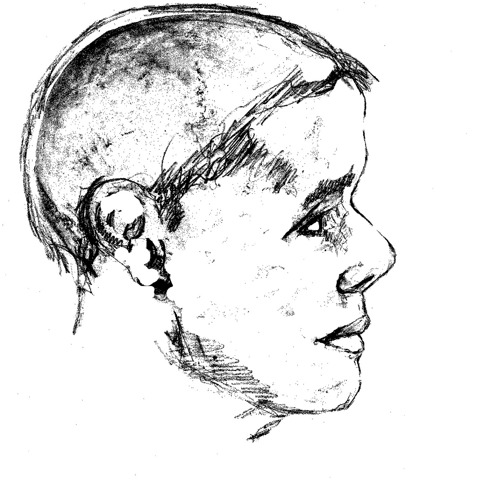
After removing most of the base photograph and refining the
facial features we are left with what may be a faithful likeness
of this unknown soldier, killed in Spotsylvania, Virginia.

    Of course, we do not know if he had facial hair or precisely what age he was. A more professional working of the specimen can yield many more tell-tale clues to these details. Perhaps one day the funding may become available to the Museum to help put a face on all the unknowns that reside in the drawers of the collection. No matter what the circumstances that brought this man's life to an end, all should be accorded the dignity of recognition as a human being. I hope this may be some encouragement toward that goal.

A photograph taken of human remains during Dr. Bontecou's trip to Spotsylvania County
in April of 1866. Bontecou had a photographic team accompany him on this journey. For
 further information, I will suggest an article I wrote for the March/April 2009 issue of
Civil War Times Magazine, introducing my studies of these images and the route taken
by Bontecou and his entourage. I continue to work on a book length manuscript as well.

    In September 1865, Northern journalist John T. Trowbridge toured the war-torn Spotsylvania region with a local guide, and witnessed the same unburied bodies Dr. Bontecou would find nearly a year later. From his book The South: A Tour of Its Battlefields and Ruined Cities, he describes his macabre encounter in the Wilderness region:

    "And what appalling spectacle is this? In the cover of thick woods, the unburied remains of two soldiers -- two skeletons side by side, two skulls almost touching each other, like the cheeks of sleepers! I came upon them unawares as I picked my way among scrub oak. I knew that scores of such sights could be seen here a few weeks before; but the United States Government had sent to have its unburied dead collected together in the two national cemeteries of the Wilderness; and I hoped the work was faithfully done.
    "They was No'th Carolinians; that's why they didn't bury 'em," said Elijah, after a careful examination of the buttons fallen from the rotted clothing.
    The buttons may have told a true story: North Carolinians they may have been; yet I could not believe this to be the true reason why they had not been decently interred. It must have been that these bodies, and others we found afterwards, were overlooked by the party sent to construct the cemeteries. It was shameful negligence, to say the least.
    The cemetery was nearby -- a little clearing surrounded by a picket fence and comprising seventy trenches, each containing the remains of I know not how many dead. Each trench was marked with a headboard inscribed: "Unknown United States soldier, killed may, 1864."
    Elijah said that the words United States soldiers indicated plainly that it had not been the intention to bury Rebels there. As a grim sarcasm on this neglect, somebody had flung three human skulls over the paling into the cemetery, where they lay blanching among the graves."

Thursday, January 12, 2012

Gettysburg - Harvest of Death - Location Found, January 11, 2012, Confirmed June 14, 2012

REVISION: I have floated the revised analysis I am posting here for several years, but have not, till now, published it on this blog. I stated it publicly in April 2016, on location, in the presence of NPS Historian John Heiser, and numerous other attendees. I am very convinced that the dead seen in these images are members of the 151st Pennsylvania Infantry Regiment. Initially I would have thought them to be the dead of the 24th Michigan, but what I understand now shows me that the Iron Brigade skirted to the north of this location, falling back, past the 151st Pennsylvania who were going to take the brunt of Virginia and North Carolina units pressing through the woods. The 151st Pennsylvania made their stand on the crest, in front of the edge of the woods where Reynolds fell, until falling back across the field bordered by fences to the north and south. This field is the reason why the "Field Where Reynolds Fell" captioning is derived by Gardner. I am officially publishing this revision on 10/12/2018.

Be sure to read the post attached to our February 25, 2013 link. Click here. It further demonstrates this site is located on the first day's field. Clear visual evidence. 

This post has been revised to reflect the corrected findings of my October 6, 2012 return visit.
Be sure to read the October 12, 2012 post on this subject by clicking here. It contains more current information on the location.
Additional information can be found on the June 14, 2012 post by clicking here.


     One of the most elusive group of Civil War battlefield photographs has been the image known as “The Harvest of Death” and its companion images, showing the same bodies from a near opposite angle. The group was made in the days following the battle, most probably July 6, 1863. There have been three prevailing theories as to the precise location of this ghastly scene. Since 1975, historian William A. Frassanito has felt comfortable in his belief that the group of photos was taken somewhere near the Rose Farm and the Emmitsburg Road. The greatest challenge has been in trying to locate a piece of land where all terrain features cooperate, in both directions, to make the theory work. Granted, doing this has been made even that more difficult by over a century’s growth and/or removal  of wood lines and other obstructions, as well as potential modifications to the landscape surface. The mission has continued for another thirty-seven years as numerous investigators have scoured the battlefield landscape to find the right combination of elements.

Gardner caption, "View in field on right wing."
Library of Congress collection.

     In May 2011, Gettysburg National Park Service Historian Scott Hartwig published his own theory, located in an area below the Chambersburg Pike, near McPherson’s Woods that seemed to work, and was much more in keeping with the original captioning of the published images by photographer Alexander Gardner. It runs along the Park Service road, Reynolds Avenue South.

     Most recently, historian Jerry Coates has spent considerable time investigating an area south of Gettysburg, and west of the Emmitsburg Road. This theory stayed more within the confines of the original Frassanito analysis, but was supplemented by a more in depth study of the uniforms the dead are wearing and attempting to use this criteria to narrow down the numerical potential as to who they might have been and thus the field of battle these men would have been engaged on in July 1863. He has come up with very similar terrain and some good arguments.

     However, my own investigative work has concluded that of all these prevailing theories, the one that seems to come the closest is Scott Hartwig’s on the first day’s battlefield. But, although very well founded and assembled with sound judgment, Hartwig’s theorized location has its faults and can be termed with the old expression, “Right church, wrong pew.”

     What all the prevailing theories lacked was a concrete feature or landmark that would anchor the image to an indisputable location. My examination of the series of images has discovered what appears to be that necessary clue. The clue has been available in plain sight to all that have looked at the glass negatives for the stereo pairs, and quite possibly the 8 X 10 glass negative, although that full image is not printed or available online presently by the Library of Congress, but is referred to by William Frassanito and shown in cropped form on page 227 of his Gettysburg: A Journey In Time. In many prints of the image entitled “Field where General Reynolds Fell”, the full image has been cropped and has thus removed the landmark feature. The landmark looks like none other than the residence of Mrs. Mary Thompson, known more famously as “Lee’s Headquarters”. In the upper right hand corner, again invariably cropped out in published formats, the house is easily discernible along the horizon line. It is understandable that it could be easily overlooked as just another shadow in the line of trees, but when magnified, and compared to wartime images of the structure, it becomes more than obvious. In utilizing the Thompson house as the anchor for this image, it becomes far easier to establish a camera position, and thus, possibly prove that Gardner’s original captioning was spot on as to the vicinity of the battlefield.

Is this the home of Mrs. Mary Thompson, "Lee's Headquarters,
as seen in an enlargement of one half of a stereo glass negative?
Annotated copy of the previous enlargement showing key elements.
Find these same elements in the image below for comparison.
All images are clickable for enlarged viewing.
Photograph of Mrs. Thompson's house, attributable to Mathew Brady.
Note the white fence, chimney, and trees on either side of the building compared with
 those features in the enlarged views preceding. Is this the rock solid clue to these images?
Library of Congress collection.

Overlay with Thompson house image by Brady at 75 percent
transparency over top shadows seen in Gardner image, right horizon line.
Brady's street level image was of course taken close up, but even at
464 yards, the shape of the house and surrounding trees is discernible.

     Two field reconnaissance trips to the Gettysburg field had given me the evidence to support this theory. On November 18, 2011 and January 11, 2012, my investigations concluded that the dead in this series of exposures were likely killed south of the Chambersburg Pike, between McPherson’s Ridge and Seminary Ridge. This section of the field was just below the northernmost of two fence lines that ran parallel to the Pike and enclosed a field that included the Herbst Woods in its western extreme. If so, these men fell approximately 100 yards east of the spot marked where General Reynolds fell, and roughly 460 yards southwest of Mrs. Thompson’s house. The camera location is roughly 290 yards northeast of Scott Hartwig’s theorized conclusion, which was south of the lower enclosing fence, and too far south of the Thompson house to have allowed for the structure to appear as it does in scale along the Chambersburg Pike Ridge. Jerry Coates theoretical location is approximately one and three quarter miles south of the Seminary Ridge killing field.

Gardner's camera position adjusted October 6, 2012 with further corrections October 12.
 Click on this and all images to enlarge.
Green triangles indicate approximate field of view of lens for both images.
Light tan lines indicate approximate war-era fences separating field.

The Gardner image, note the faint Thompson house at upper right, along horizon.


Approximate same view as of October 6, 2012. Thompson house to right of motel complex.
Gardner's "Harvest of Death"
See my September 28, 2012 posting regarding the horizon line and
 apparent doctoring of the image by Alexander Gardner.
Approximate same view as of October 6, 2012.
For questions regarding the horizon line, visit this additional post on the subject.
Initial investigation, and attempt to set up the shot towards the Thompson house.
Seminary Ridge is in the background. November 18, 2011.
 Photo by James Anderson.
Looking for the correct view toward the Thompson house on November 18, 2011.
Photo by James Anderson

Be sure to visit the June 27, 2012 post
for the complete story
Monument to the 24th Michigan overlooking
Willoughby's Run. January 11, 2012.
These men, and others of the Iron Brigade, exited this area, and fled past the
151st Pennsylvania who would cover their retreat, taking heavy casualties.
Mrs. Thompson's house as it appeared January 11, 2012 with the addition of
dormer windows expanding the second floor. At the time of this photograph
the home served as the Lee's Headquarters Museum.


View of the field from Reynold's Avenue South, June 14, 2012.


Wednesday, December 14, 2011

A Quiet 149th Anniversary at Fredericksburg Battlefield - December 13, 2011

One hundred and forty-nine years ago yesterday, the town and surrounding landscape of Fredericksburg, Virginia was crowded with two massive armies. Over one hundred and eighty-five thousand men participated in a slug fest that left nearly two thousand dead and close to fourteen thousand wounded. Along with the human wreckage, the town itself had been severely damaged by an artillery exchange and resulting fires. Private residences and businesses were looted and ransacked by unrestrained factions of the Union Army. In the months leading up to the battle, Confederate forces had destroyed connecting bridges with Stafford County, across the Rappahanock River, as an impediment to anticipated Union occupation. 
December 13, 2011: The view from City Dock where Union men massed prior
 to funneling through the town streets, toward a severe defeat on an open plain beyond.

Looking toward the location of the middle of three pontoon bridge crossings
that streatched along four miles of the riverfront.
The boyhood home of George Washington, Ferry Farm, is on the opposite side.

"The Sentry Box", built by Revolutionary War general George Weedon,
sustained extensive damage during the Union bombardment of December
11, 1862. It was repaired in the years following the war, and remains a
private residence and landmark within the historic district of today's city.

A little under a mile beyond the dock, across the former open plain, the
 infamous stone wall and sunken road along the base of Marye's Heights
 is a silent reminder of the horrific exchange between North and South.
Confederate defenders took shelter here and poured a decimating hail
 of lead at approaching Union brigades who were time and time again
repulsed by the withering onslaught.

The site of the Martha Stephans house along the Sunken Road.
Legend holds that she remained in her home during the battle
so as to provide aid for wounded soldiers.

The moss covered, stately entrance gate to Brompton, the former
home of the Marye family, and the heights that bear their name.

Brompton, now the residence of the president of the University of
Mary Washington, stands atop the heights where Confederate
hellfire once rained down on the approaching blue waves below.

The monument to South Carolina soldier, Sgt. Richard R. Kirkland,
who, it is said, gave water the morning after the battle to the Union
wounded in front of the stone wall, earning the nickname, "The Angel
of Marye's Heights. A commemorative ceremony is held each year here.

Your blog host casts a long shadow around 11:30 AM with the camera
 looking south, along the road. At that time, one hundred and forty-nine
years before, the wall at left (rebuilt in 2004) was lined with thousand of
 Confederate defenders who successfuly repulsed the Union attacks as
the day wore on.  Near this spot, Confederate general Thomas R. R. Cobb
was mortally wounded. A small monument marks the location where he fell.

Earlier posts on this blog provide further information regarding the Sunken Road:
and


Monday, December 12, 2011

Legomania 1993 Presents: The Battle of Fredericksburg

I post this with tongue-in-cheek. Nothing serious here folks. As simplistic as this little film is, I couldn't pass up the opportunity to post it as we are in the anniversary days of the December 1862 battle. I came across it on the Internet, and I have nothing more to say about it. It is what it is, in the tradition of stop-motion classics of the Christmas season, Rudolph and Frosty. Take a gander.

Sunday, December 4, 2011

Update to Alrich and Alsop Family Connection: From An Anonymous Tip

An Anonymous comment to our post of May 31, 2011, added 12/4/2011, points out the widow Alsop's obituary in the Daily Star, December 6, 1915. That obit clearly states that she died "peacefully at the residence of Mr. S.R. Alrich". This may indeed be a clue as to the connection with the Alrich family. That clue had remained embarrassingly unobserved by your blog host until this anonymous tip. An immediate assumption would make this "Mrs. S. R. Alrich" to be Annie, the wife of Samuel Alrich, but his middle initial was "W" according to census records. Those fine details remain still uncertain, but there is now a good indication that Susan M. Alsop was at least a friend of the Alrich family, possibly considered an "Aunt", as many times older friends of a family are called "Aunt" or "Uncle" by children, even if there is no blood or marriage connection. We shall persevere.
Our post of Jun 23, 2011, found here, provides other details in this story.
Our first post regarding this image appeared April 5, 2011, and can be found here.


The image found in the attic of the Alrich home.
Collection of Spotsylvania County Museum.
Image restoration by John Cummings.
The inscription on the back of that image.

Susan M. Alsop in her later years.
Courtesy of Jerry Alsup.

Saturday, November 26, 2011

The Gettysburg National Museum Site - Then & Now - Photo Essay

Continuing our field trip visit to Gettysburg, Pennsylvania.
 A look at the the famous Rosensteel Museum.

The original 1921 era National Museum which housed the Rosensteel
collection. The collection began in 1863 by sixteen year old John
Rosensteel, who started collecting artifacts off of the field of battle.
This image is from a souvenir postcard from that time.
This structure stood across from the entrance to the National
Cemetery on Taneytown Road.

The expanded museum building as it looked in March of 2009, during the demolition
process. The building was sold and its 89,246 piece collection given to the National Park
Service in 1971. The NPS continued to use the facility as their Visitor Center
until 2009 when a larger building was opened below Hunt Avenue, between
Baltimore Pike and Taneytown Road. The site of the Rosensteel building
was to be torn down and the land restored to its 1863 appearance.
March 2009

November 2011

A view of the 1921 balcony in March 2009.
During their ownership, the Rosensteel family
lived above the museum. Those rooms became
offices for the NPS when they moved in.

The same view on November 18, 2011

In this March 2009 photograph, the second expansion of the building
is being taken down. This section had housed the original Electric Map
attraction in 1938. It was a popular tourist destination and gave a narrated
orientation program that explained the three day battle.

The same view on November 18, 2011.

A Civil War Centennial era postcard with a bus load of tourists arriving.

Similar view as seen in March 2009, during the demolition process.
Brochures for the museum. At left is a 1957 version. At right is a 1963
edition after a larger and expanded Electric Map feature was opened.

The inside of the 1957 brochure discusses the 1955 expansion of
the building which tripled their collection display space.

From the 1963 brochure, a view of the improved Electric Map
auditorium with a 960 person capacity.

The beginning of tearing down the Electric Map auditorium.
March 2009.

The 1955 expansion and office space are falling to the wrecking
crew in this March 2009 photograph. Nothing remains today of
this facility except the large parking lot and sidewalk.

Tuesday, November 22, 2011

Spotsylvania's 23rd USCTs Marched In Gettysburg Remembrance Day Parade 11-19-2011

The 23rd United States Colored Troops took a trip to Gettysburg, PA to participate proudly in the 148th Anniversary Commemoration of the Gettysburg Address, on November 19, 2011.
Forming up, moments before the start of the parade.
Left to right: Jimmy Price, Steward Henderson, James Anderson,
Kevin Williams, and John Cummings, your blog host.
Taking the turn onto Steinwehr Avenue (historic Emmitsburg Road),
from Baltimore Street, following the route taken by President Lincoln.
This photo courtesy of Rachel Zaborowski and Michael Colosimo.
Earlier that morning, keynote speaker Stephan Lang presented some
fittingly dramatic and moving remarks before the large audience
assembled at the National Cemetery Rostrum.
An actor and playwright, Lang is known for his many film roles
including portrayals of Confederate generals Pickett and Jackson.
Currently he stars in the science fiction television series Terra Nova.
After the program at the Rostrum, there was a graveside salute to
USCTs in the National Cemetery.
At right, Millicent Sparks gives a stirring presentation as
abolitionist, humanitarian, and Union spy, Harriet Tubman.
23rd USCT member Kevin Williams salutes the final resting place of one
 of two African American veterans buried in the Soldiers' National Cemetery,
Charles H. Parker, of the 3rd Regiment United States Colored Troops.
Photo by James Anderson.