Battlefield Guide Services

Monday, February 21, 2011

Earthwork Preservation and Protection: Lessons of the past in consideration of the future.

The Civil War Roundtable of Franklin, Virginia, on November 12, 1957, stand posed directly on the Bloody Angle, at the point where the Union line is conjoined with the Confederate parapet. To the left of the group is NPS historian, Ralph Happel, who had served as their guide at the adjacent contact station, not visible in this image. The view is looking east, along the face of the Salient. Note the large cedar tree looming immediately to their backs at right. This photograph is from the archives of the F&SNMP.
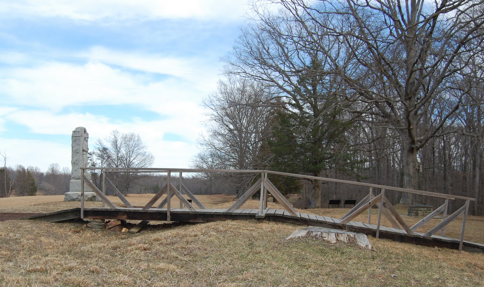
The same spot, fifty-four years later. The Bloody Angle is protected  from most intrusive pedestrian incursions by virtue of this wooden bridge, due to be removed at some point in the very near future. Previous posts on this blog, here, here, and here, have covered the construction of a new bridge futher down the line. Note the stump of the large cedar tree at right middle, immediately to this side of the bridge. The cedar was removed a few years ago to help restore the unobscured vista of the Bloody Angle, to that which the soldiers would have experienced. The cedar tree had been planted in the early days of the park as an ill-conceived landscaping measure, one of the conflicts of "battlefield park" versus "natural park" philosophies.
Sparingly placed, so as to to be themselves non intrusive, signs such as these are designed to instill a discipline within the visitor to be mindful of the resource's delicate condition. Sadly, this does escape the consciousness of many, and on a daily basis a casual observer will witness numerous, shocking examples.
The question for the future must now be, "Will the park visitor dutifully follow the new trail system, or will they feel unflinchingly compelled to veer from the path and walk on the earthworks?" The future will tell.

Tuesday, February 8, 2011

23rd USCT Re-forming for Sesquicentennial Commemorations in Spotsylvania

Gathering for the organizational meeting of the 23rd USCT
are left to right: Rev. Hashmel Turner, Col. Horace McCaskill Jr. USA, (Ret),
Steward Henderson, Roger Braxton, and John F. Cummings III

Over the past decade there has been some intense interest focused on the Spotsylvania experience of the 23rd United States Colored Troops, a regiment comprised of former slaves, many from the County and surrounding area. Prior to May 15, 1864, USCT's attached to the Army of the Potomac were routinely assigned to non combat roles, primarily guarding supply wagon trains. Organised at Camp Casey, near the modern day site of the Pentagon in Arlington, Virginia, the 23rd was assigned to the 4th Division of the 9th Corps, led by Brigadier General Edward Ferrero, a well known dance instructor in pre-war civilian life.

On the morning of May 15, Confederate cavalry was probing along the back roads far north of the prior week's concentration of fighting. Their goal was to harass Union hospital sites and supply lines, with the intent of liberating as much as they could with minimal casualties. Riding hard along the Catharpin Road towards the Old Plank Road intersection, the southern horsemen came upon the 2nd Ohio Cavalry Regiment who were resting near Piney Branch Church. Panicked and outnumbered, the Ohio troopers took off pell-mell toward the Alrich farm, a good mile and a third away. From there some of the terror stricken Union horsemen proceeded north to alert the closest possible reinforcements. Near the Chancellor House ruins, the 23rd USCT, sprang to the call and proceeding south, encountered the approaching Confederates in what would be their very first exchange of fire with the Army of Northern Virginia. The southerners fell back, suddenly outnumbered, with the 23rd holding the intersection.

This historic encounter has until recently gone unappreciated as a major landmark on the road to the end of slavery in America. However, plans are now in development to commemorate this contest by placing an interpretive marker near the place the Ohio troops were first surprised. The intersection where the 23rd USCT actually fired upon the Confederate Cavalry has been deemed too dangerous to place a safe pulloff area.

In anticipation of the opportunities during the Sesquicentennial to tell the story of the 23rd, I began to talk with friend Steward Henderson about assembling a representative unit as re-enactors. Thus far there has been substantial interest in making such a portrayal available over the next four years. Additional interest has been expressed by the John J. Wright Educational & Cultural Center Museum who will partner with us in our efforts


National Park Service Historian, Eric Mink, has spent numerous hours delving into the service and pension files of Spotsylvania men who had served in the 23rd USCT. His work has been invaluable toward assembling the story of these men's lives. Some of his findings have been posted on another blog, here and here.

National Park Service Historian, Noel Harrison has also written a blog posting here, detailing the location of the skirmish and the encounter that brought it about.


Brigadier General Ferrero is seated at lower left with members of his staff,
near Petersburg, Virginia in the summer of 1864. An armed sentry, possibly a
member of the 23rd, stands at his post to the right of the white officers.


Monday, February 7, 2011

Manassas - Another Project nears completion

Those who know me are aware that I have been working several book projects in tandem. One regarding local photography is close to seven years in the mix. However, in the next few weeks, I anticipate sending another finished manuscript to the publisher, this time focusing on the Manassas Battlefields.

Before moving to Spotsylvania, I lived in Northern Virginia, in Fairfax County, for thirty-nine years. Growing up within ten miles of Manassas/Bull Run, enabled me to nurture my early interest in Civil War history, and I visited the battlefield there countless times, both as a child with my parents and even more frequently as a young adult. There has always been something strangely alluring about the Manassas Battlefield for me, something incorporeal.  Logically, all the battlefields should manifest these same conditions, but with every return trip I make to the "Plains of Manassas", I am reinforced with these strange emotions.

My Manassas project is heavily built on "then & now" comparrison photographs. Oftentimes in doing this comparrison work, one finds the landscape has changed over a century and half to such an extent that true side by side alignment is difficult to impossible, particularly when the subject matter sits within a wooded area.

Last week (February 2), I took the opportunity to revisit one last time before finishing, an area that normally is obscurred by heavy foliage within trees. My goal there was to use a recent snow fall to provide a better ground contrast against the trees and background sky. I was delighted with the results since prior attempts were at other times of the year, and failed to show the terrain features needed for a true "then & now" match up.

The black and white image below is the original wartime photograph taken in March 1862, showing two boys knealing in front of a row of water logged soldier burials. The site is on a small, flat, bottom area in front of the west face of the ridge that Sudley Church sits on. The church can be seen through the trees at upper left. After the Battle of First Bull Run, in July 1861, this area was used for a field hospital, along with the church building. As is typical in such situations, soldiers who did not survive the ordeal were buried hastily in shallow graves nearby. 

Although the church building has been rebuilt since the Civil War, my modern, color photograph demonstrates the surrounding landscape has retained the same characteristics it displayed in 1862, especially the thin trees, albiet now entangled in thorny undergrowth. Fortunately, the property is still owned by the church and one can not anticipate an encroachment to destroy this hallowed ground.

My goal is to have this book in print by July, in time for the 150th Anniversary of First Manassas.

March 1862, by George N. Barnard
February 2011, by John F. Cummings III

Official Virginia Civil War Sesquicentennial Vodcast


Much of the dramatic footage seen in the above video is compiled from the combined talents of John Hennessy, Chief Historian of the Fredericksburg and Spotsylvania National Military Park, and Media Magic Productions of Lansing, Michigan. The material was shot over several years locally, with many extras culled from the community, to produce three documentary films exhibited and sold at the Battlefield Park, Fredericksburg, Chancellorsville and Virginians Desolate, Virginians Free. John Hennessy wrote the script for the films and provided on-site consultation during the filming and post-production. A fourth film, on the Wilderness and Spotsylvania is in the formative stages.

John has also played a significant role in orchestrating the regional preparations for the Civil War Sesquicentennial. An indefatigable worker, possessed by an indomitable spirit, John personifies the term "multitasking". We can expect many great things over the next four years from John and the entire staff of the F&SNMP.

John Hennessy is seen above, lecturing on the local civilian experience
 during the Civil War, at the 145th Anniversary Re-enactment
 of the Battle of Chancellorsville, May 2008. Photo by Julie Bell.

A NEW YEAR IS HERE, and the Sesquicentennial too


It has been a few months since I have posted on here. There had been some distractions that took precedence over devoting time to blog, the most pressing of which had been family medical necessity. Just a few days before Christmas, my wife had hip replacement surgery, and I am happy to say she has recovered wonderfully. The Lord has really blessed us. After two and a half years of increasing pain and decreasing mobility, she has come back renewed, and looking forward to once again hiking the battlefields and enjoying our research projects together.

The other major item that consumed my time was the completion of my second book's manuscript and delivering it to the publisher. It is an illustrated history of Spotsylvania County that focuses on the impact of the Civil War, the establishment of the battlefield park, and the continual struggle to preserve significant lands along with the development of a tourism ethic in the County government. The last chapter in the book is devoted to the period of 1999 to 2010, where a mixed bag of preservation victories and placating rhetoric from the Board of Supervisors, defined Spotsylvania County as one of the most endangered battlefield regions in the east. The current release date from the publisher is June 27, 2011. I will keep everyone updated on here as we get closer.

Additionally, I have begun to provide a bi-weekly Civil War column for an on-line news magazine called Fredericksburg Patch. Outside of one deliberate reworking of an early post from this blog, the goal will be to supply fresh material that compliments what I post here. Essentially I have doubled my blog-like workload, but I will go at it with spirit and hope everyone checks in over there and enjoys what the site has to offer the region. I find the Patch to be a refreshing source of local news with the promise of a online community feel.

Now we are into the first year of the Sesquicentennial Commemoration of the Civil War, 2011-2015. I am expecting some exciting events and educational opportunities over the next four years in the Fredericksburg/Spotsylvania area.

My goal on this blog will continue to be an ongoing source of interesting perspectives of the Civil War and its cultural legacy.

Friday, October 29, 2010

Related Lands: The Florence Stockade - Florence County, South Carolina

In the late summer of 1864, as Union General Sherman was pressing his forces around Atlanta, there was cause for concern that the POW stockade at Andersonville, Georgia could be overrun, allowing the liberation of the Union men held there. In an effort to prevent this, a stockade was prepared in Florence, South Carolina, approximately 90 miles north of Charleston, and it was to there that the able bodied prisoners of Andersonville were to be transferred by train. The first prisoners would arrive in September. In the five months this stockade was in operation, as many as 18,000 Union soldiers were held there. With an initial death rate of 20 to 30 men a day, a total of about 2,800 would perish. Among them were as many as 14 of the Pennsylvania and New Jersey soldiers captured on May 14, 1864 during the fighting on Myer's Hill, near Spotsylvania Courthouse. Accurate death and burial records failed to survive the war, and these men may likely be interred in the 16 burial trenches containing 2,167 "unknowns", at what is now the Florence National Cemetery.
We visited Florence on Monday, October 18, on our journey back to Spotsylvania from a family gathering in Charleston. My special thanks to NPS historian Eric Mink for his last minute trip advice as we traveled up Interstate 95.
                                  
Entrance to the Florence National Cemetery


One of the 32 upright marble headstones that mark sections of the 16 burial trenches.

On the south side of the cemetery, at the end of Stockade Road, is the site of the former prison camp, maintained and interpreted by the Friends of the Florence Stockade, who have a Facebook page currently here. The above photograph shows an informational Gazebo with numerous illustrated panels detailing the history of the site. It is stop # 1 on a 16 stop walking trail.
Map detailing the stockade and surrounding defensive works.
The stockade itself was 23.5 acres, 3 acres smaller than Andersonville.

This view is taken from near the south west corner of the stockade.
The path runs parallel to what was the south wall of the stockade.

This illustration looks from the south wall along the sole water source for the prison, the Pye Branch of Stockade Creek. The drawings were created by James E, Taylor for Ezra Hoyt Ripple's published account of his experiences as a prisoner of war. Drinking water was taken from the northern (far) third of the creek, the middle was used for bathing, and the final third was utilized for the latrine, a wooden, open air facility seen at lower right, running along the creek length. Conditions are said to have been at least equal to and in some estimations, worse than those suffered at Andersonville.
An incident at the Stockade, also illustrated by Taylor. Note the similarity to Andersonville's construction and prisoner living conditions.

Saturday, October 9, 2010

Related Lands - Andersonville Prison, Macon and Sumter Counties, Georgia


On May 14, 1864, Pvt. Jesse A. Adams of the 10th New Jersey Infantry Regiment was captured by Confederate forces overwhelming his unit during fighting on Myer's Hill, near Spotsylvania Courthouse. The above image features an original photograph of Adams taken shortly after his enlistment, November 14, 1861, by the regimental photographer, J. B. Brown.
Adams was sent nearly 700 miles south to the Andersonville, GA prison camp.

Today, the former prison is now the home of the National Prisoner of War Museum,
administered by the National Park Service.

This is the reconstructed northeast corner of the stockade that contained the prisoners. The view is looking southwest. Towering above the walls are representatives of the guard towers that monitored the prisoner activities inside the compound.

Inside that compound today are a sampling of makeshift shelters that prisoners struggled to maintain inside the 26.5 acre rectangular enclosure. Barracks that had been originally planned to house the prisoners were never built due to shortage of materials and manpower.

A photograph taken on August 17, 1864 from one of the guard towers, looking northwest. The top of the stockade wall is running along the right hand edge of the image. At ground level, just to the left of the stockade, is the infamous "dead line", which if crossed, would mean being shot by the guards above.

Here is the rebuilt "north gate" into the compound on the west wall of the stockade. Its name derives from being on the "north" side of a creek that flowed through the compound. A fellow inmate of Adams wrote of the horrors new prisoners witnessed upon arrival, "Once inside... men exclaimed 'Is this hell?' "

One of the NPS interpretive signs inside the gate.

Looking across the site of the compound from near the southwest corner. The location of the stockade walls and dead line are indicated by white stakes. The location of the rancid creek flowing through the prison runs along the low area between the high ground. It served as a drinking and bathing water source as well as the latrine. Dysentery was rampant. Of the near 45,000 men held here, 12,913 would die from starvation, malnutrition, and disease.

Among the dead was Jesse Adams, who succumbed to pneumonia on August 2, 1864,
 a mere eleven weeks after his capture. His remains rest under the soil of Georgia.


For myself, as a student of the Civil War for now over forty years, my visit to the Andersonville Prison site in 2008 was a profound experience. I have visited many battlefields and had been to the location of POW facilities in Richmond, Virginia, chiefly Belle Isle, where approximately 1,000 prisoners died out of 30,000, and the former location of Libby Prison, but visiting Andersonville changed it all for me. I can't see the war in its entirety in the same light as I did before. It is no longer simply the strategy and tactics of battles or the clash of political ideals. It is no longer "Still Rebels, Still Yankees" as Donald Davidson opined.

Monday, September 27, 2010

Taming The Wilderness - Living History at Ellwood, September 26, 2010

The Spotsylvania County plantation house known as "Ellwood", was the site of an informative living history event on Sunday, September 26. The threat of rain kept some of the planned displays from attending unfortunately, but those that did set up provided a top notch presentation. Hosted by the Fredericksburg and Spotsylvania National Military Park and the Friends of Wilderness Battlefield, the theme for the day was "Taming the Wilderness: Featuring some of the key trades, skills, and crafts necessary to build a house and provide for a family on the Virginia frontier in the late 1700's."

Built in circa 1790, Ellwood was once the center of a 5,000 - acre estate.

Lively musical performances on Ellwood's front porch.

On the lawn, Melondy Phillips demonstrated the preparation of animal hides.
Here, she discusses the softening of deer skins. Very informative.

A member of the Fredericksburg Spinners and Weavers Guild
demonstrates a loom, using cotton threads to make kitchen towels.

"Wenches" Elaine and Robin discuss the contributions of 18th Century Tavern
Life to our modern day language, with idioms such as "mind your P's and Q's",
 "bottoms up!", and "he's not playing with a full deck."

Craig Jacobs, owner of Salvagewrights Ltd., chats in the afternoon shade with
some of his friends who presented information on log hewing, architectural and
decorative details, and antique woodworking tools and their applications.
Here, they are sitting on a partially hand hewn beam, which that morning had
been a standing tree. They are masters at their craft.

Friday, September 17, 2010

The Rain.... a music video by a native Virginian, Scott Miller


Here's a song about the Battle of Spotsylvania. I happened upon this video just about an hour ago. Shortly thereafter I visited Scott Miller's website so I could see who this gentleman was. I was surprised to find that he is actually playing this evening, September 17, 2010, in Ashland, Virginia, just down the road a bit from Spotsylvania. From what I gather he currently lives in Tennessee and is presently on tour, making only two more stops in Virginia this time around.

It takes a minute and some eighteen seconds to get beyond the storm clouds and lightening, but for the rest of the video (and I can not tell if this is an official video released by the artist, or one assembled by a fan), but the remainder does have some footage of soldiers firing from a fixed position and then advancing into a dark and misty morning light. From the bio information I can find it appears Scott is a big fan of history, and a native Virginian from the town of Swoope, in the "breadbasket" of the former Confederacy.

Singer/songwriter, Scott Miller

Wednesday, September 15, 2010

Time Keeps On Slippin' Into The Future........... April 1939 to August 2010

Seventy-one years ago, and seventy-five years after the conflict that raged over the landscape, the National Park Service treated visitors to extensive restorations of battlefield earthworks at the Spotsylvania unit of the F&SNMP.

The planning and construction of these sections has been recently detailed by NPS Historian, Eric Mink, in a three part series at the web blog "Mysteries and Conundrums". Readers can follow Eric’s presentation by clicking, here, for the first installment.

In the “then and now” slide show below, I reveal how the landscape has progressed over time. Most profoundly, the viewer will notice the disappearance of the hard surface road that had also been built in the 1930s. This view looks over the trench restoration, looking essentially south, toward the intersection of Bloody Angle Drive, Gordon Drive, and Burnside Drive. In the 1930s, Burnside Drive was called Grant Drive East. Bloody Angle Drive has been totally removed except for the grading over which it ran. The creation of a level base for the road to follow involved numerous, intrusive alterations that remain in place today, and can confuse the pedestrian experience. Unfortunately, it does not seem that detailed working plans of the 1930s road construction exist in archived files, otherwise a more thorough return of the 1864 terrain could be attempted.

The initial, black and white photograph seen here, was taken in April, 1939, for a collection of images to be displayed at the 1939-1940 World’s Fair in New York. It was part of the Commonwealth of Virginia exhibit in the Court of States.
Please click on the image, it will take you to a larger screen for greater detail viewing. When the "Picasa" window opens, click the "Full Screen" button at upper left to easily see a rolling slide show of the five images that make up the "then and now" transition.


The photograph below, taken around October of 1935, shows workers nearing the completion of the project. The view is looking roughly north from inside the salient. One has to speculate on the degree of arbitrary features built into this particular "restoration", despite documentation of a careful and studied process at other locations. A concerted effort was made to construct this in a deliberate perception of an 1866 photograph, although no hard evidence existed to substantiate the notion. A rendering of the 1866 photograph was later displayed in a weatherproof frame nearby, and undoubtedly led many visitors to believe they were witnessing a restoration of the genuine article. The 1939 photograph in the then and now study, shows visitors standing in front of the frame. Exactly when this restoration was dismantled is not clear, but its misleading features, without the log revetment, remain as a part of the present day visitor experience.

In the aerial photograph below, taken in October 2008, the red arrow points in the direction of the camera for the slide show image. This view also shows the pedestrian trail created by the removal of Bloody Angle Drive.