In 1935, the F&SNMP was not yet a decade old, but work was being done to optimize the visitor experience. A road was under construction to bring vehicles around the entire inside of the Mule Shoe Salient, soon to be named Bloody Angle Drive. A large orientation sign had been placed near the Angle, the first of many that would, over time, be installed, removed, rewritten, replaced by something better, and then, repositioned numerous times, only to now be declared obsolete. The black and white photograph below, was taken in September of 1935. Interestingly, the camera position is directly in front of the McGowan's Brigade Monument, installed in May of 2009. The view looks roughly 33 degrees north east.
As you watch the slide show, notice the subtle changes. The roadway, not yet completed in the 1935 view, is in today's shot, totally removed in favor of the more intimate, pedestrian experience.
The trees in this slide show are interesting to take note of, particularly the three oaks that dominate the right hand side of the image. The left and center of the three are still with us today, now probably at or approaching their own centennial anniversary. They flank the path that takes visitors to the bridge crossing at the monuments. The third oak, at far right, has been gone for many years, having stood near the orientation compass at the top of the rise. Also profoundly changing over the years are the trees of the distant horizon line, and barely visible in the oldest image. Today, they create a wooded buffer, separating the Park from its new subdivision neighbor to the north. Other trees that were permitted to grow out in the swales, beyond the trench line, can be seen achieving their stature on the landscape. Currently, some of those trees have borne the extremes of conditions and have succumb.
Soon, the wooden bridge across the Bloody Angle will be removed. Time marches on.
Please click on the image, it will take you to a larger screen for greater detail viewing.
When the "Picasa" window opens, click the "Full Screen" button at upper left to easily see a rolling slide show of the five images that make up the "then and now" transition.
Friday, August 27, 2010

Monday, August 16, 2010
Myer & Brulle Office, 317 Commerce Street, Fredericksburg... Then and Now
The post-war business of John Henry Myer and Frederick Brulle, one block up William Street (aka Commerce Street) from the Myer residence and bakery at 212. The Germania Flour Mill was one of the highly successful businesses that helped Fredericksburg pull itself out of the financial wreckage wrought by the Civil War.
Myer himself is standing to the left of the center doorway, wearing a light colored suit and a derby hat. The viewer will note how the center doorway was later converted to a double width window. At one point, William Street was also lowered, which required the addition of two steps leading up into the doorway at right, whereas it used to be at street level.
The older image used for this slide show was taken in the late 1880s or early 1890s, after the mill converted from traditional stone grinding to a more productive roller system.
The actual mill structure stood on upper Caroline Street, across from what is today, Old Mill Park. It had stood in ruins since a fire gutted it in October of 1980, but it was totally leveled in late 2009, after many years of proposed adaptive reuse failed to take hold.
Please click on the image, it will take you to a larger screen for greater detail viewing.
When the "Picasa" window opens, click the "Full Screen" button at upper left to easily see a rolling slide show of the five images that make up the "then and now" transition.
Myer himself is standing to the left of the center doorway, wearing a light colored suit and a derby hat. The viewer will note how the center doorway was later converted to a double width window. At one point, William Street was also lowered, which required the addition of two steps leading up into the doorway at right, whereas it used to be at street level.
The older image used for this slide show was taken in the late 1880s or early 1890s, after the mill converted from traditional stone grinding to a more productive roller system.
The actual mill structure stood on upper Caroline Street, across from what is today, Old Mill Park. It had stood in ruins since a fire gutted it in October of 1980, but it was totally leveled in late 2009, after many years of proposed adaptive reuse failed to take hold.
Please click on the image, it will take you to a larger screen for greater detail viewing.
When the "Picasa" window opens, click the "Full Screen" button at upper left to easily see a rolling slide show of the five images that make up the "then and now" transition.
Tuesday, August 10, 2010
Even If Etched In Stone...
Along the edge of the Wilderness Baptist Church cemetery, lie a cluster of graves belonging to the Todd family, a lineage dating back to the mid eighteenth century in Spotsylvania County. One of the stones marks the final resting place of Richard Lewis Todd, b. May 8, 1836, d. May 29, 1911. Sharing this marker is Charles Robert Todd, bearing the lines:
Killed By A Shell
October 7, 1865
At Rest
The inscribed date of death has led many visitors to speculate that Charles Robert Todd had perhaps been a civilian victim of an unexploded artillery shell, carelessly mishandled just six months after the war's end. Tragic incidents have been recorded that document such a fate. Often times children who would find "dud" projectiles, only to end up maimed or killed when a rock or hammer was applied by the hapless victim in an effort to break open their deadly find. Numerous incidents around Gettysburg are detailed by historian William A. Frassanito in his book Early Photography at Gettysburg.
The true fate of Charles Robert Todd however, is not as some have assumed, but no less tragic. The year of his death, as it is inscribed, is incorrect. The year was mistakenly entered as 1865, when the reality was 1864. The circumstances played out roughly seventy-seven miles south of Spotsylvania, near the Darbytown Road, south east of Richmond. On October 7, 1864, Private Todd of the Fredericksburg Artillery was killed during fighting north of Fort Harrison. According to former NPS Chief Historian Robert K. Krick's The Fredericksburg Artillery, a Union artillery shell had struck the muzzle of the battery's No. 4 gun, killing Todd, and severely wounding four other members of the gun crew.
It is uncertain if Charles actually shares this grave with his younger brother Richard. His remains may in fact lie near the field of battle. Richard and another brother, Oscar, both served in the 9th Virginia Cavalry.
Due to contradictory birth years recorded in the only two census records where Charles is enumerated by name, it is uncertain of his age when killed. Based on the age given in the 1850 census, we can speculate he was born in 1832, given the entered age of 18. Ten years later, in the 1860 census, his age is given as 23, a five year variance during a ten year span.
The Todd's are known most famously in Spotsylvania for the tavern location on the Brock Road which carried their name. According to historian Noel Harrison's research, the Todd family had sold the property around 1845 to Flavius Josephus Ballard who then re-sold the property in 1869. The intersection where the tavern stood still maintains the name "Todd's Tavern".


The former Todd residence, not the Tavern, as seen sometime after 1933,
in a Photograph made for the HABS HAER collections.
The house stood north of Catharpin Road, off of what is today,
Carriage Road.

An on the spot drawing made by newspaper artist William Waud, showing the October 7, 1864 battle of Darbytown Road. The position of the Fredericksburg Artillery is in the left distance, accented by the
billows of smoke emitting from the guns.
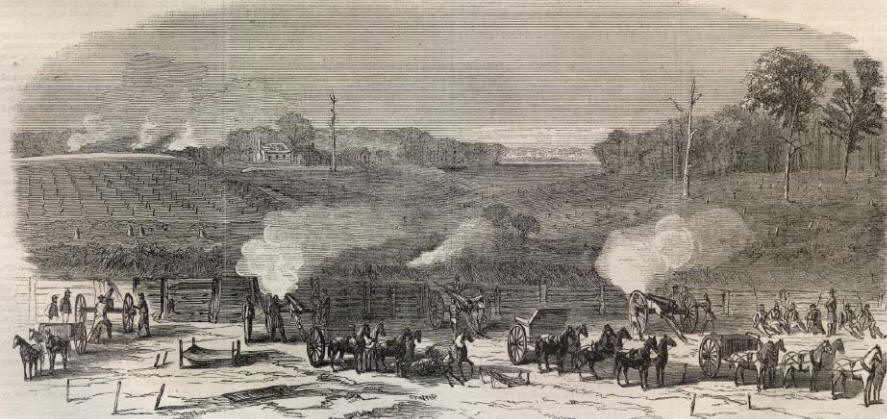
The same image as it appeared in Harper's Weekly newspaper,
October 29, 1864 issue.
Tuesday, July 20, 2010
Grave Torn Open In Freak Storm - Fredericksburg, July 16
About 6:30 on Friday evening, July 16, a freak storm took a powerful smack at downtown Fredericksburg, leaving many busted and uprooted trees, downed power lines, and damaged property in its wake. Weather forecasts had not predicted the event, and many visitors to the City were caught up in the tempest while attending a music festival along the Rappahanock River. The storm was over in less than half an hour. One woman was taken to the hospital for "a gash on her head, and another person was hit by a tent and treated for cuts by EMTs at the scene", according to the local newspaper, The Free-Lance Star.
On the other side of the City, to the west, a large tree uprooted in the Confederate Cemetery, tearing into the grave of Private Benjamin M. Blackwell, and busting numerous headstones. Blackwell had served in the 48th Virginia Infantry before being killed on May 5, 1864 in the battle of the Wilderness at the age of twenty-eight. The 1860 census shows he was a farmer, living with a relative who was a blacksmith. In the same record, Benjamin Blackwell claimed a value of $50 in personal property, not a rich man by any standard.
An interesting, and revealing article referencing Blackwell, in the journal "Civil War History", can be viewed here. A letter Blackwell wrote to his brother in late 1863, demonstrates his unease at the course of the war, and the Confederate nation's fate.
In September 2003, Hurricane Isabel left similar damage in the National Cemetery on Marye's Heights, tearing open the graves of two Union soldiers interred there.

The grave of Private Blackwell is seen here, burst open by the large tree.
A monument to to the Confederate dead is seen at center distance.

The ruptured grave is marked by a simple stone with the inscription,
B M Blackwell
VA

In amongst the branches of the fallen tree can be seen numerous other broken stones.


This view shows the overall size of the tree and the extent of the damage.
All photographs shown were taken approximately 24 hours after the storm, Saturday, July 17, 2010.
Copyright 2010, by John F. Cummings III
Images are clickable to allow for larger viewing.
Sunday, July 11, 2010
Related Lands - Confederate Works at Germanna Crossing
In late November 1863, during the opening days of the Mine Run Campaign, newspaper special artist Alfred Waud sketched Union troops exploring the newly abandoned Confederate fortifications overlooking the Germanna crossing of the Rapidan River. The crossing at Germanna dates back to the colonial-era as a major transportation route, and also served heavily throughout the Civil War as a crossing point on the Rapidan for both armies in the campaigns of 1863-1864. In the Waud sketch below, looking north, the Germanna Highway (Modern Route 3), can be seen in the middle distance. The similar, present day image below that, is taken from approximately where the soldier is standing on top of the parapet of an artillery redoubt (quad 7-3). The quad graphing was added to the original sketch for the newspaper engravers that prepared the image for publication. Click on the images to enlarge.


Approximate modern view, looking north toward Route 3.

From atop the redoubt, looking downhill toward the highway.

Western wall face of the artillery redoubts.

Looking northwest at about 300 degrees, along the south side of the Germanna Highway. The terminus of the long trench section stands in the shade at left foreground. The remains of these works are today on the campus of the Germanna Community College. Other remnants of earthworks can be found in the wooded area just north of the Germanna campus parking lot, but these are not as well maintained, and tend to get lost in the landscaping efforts around them.

An aerial photograph shows the trenches running through the woods at center. A sidewalk runs up to the area, alongside the College building.

An overall view of the area with the works outlined at lower right, above the main building of the Germanna Community College. The Germanna Ford crossing site is now obscured by the modern, double span bridge near top left. The site of Alexander Spotswood's Germanna Colony, circa 1714, is located in the woods on the north side of the highway, at center. Although it is now in Orange County, this was the location of Spotswood's manor house (1722-1750). Spotsylvania County derives its names from the former colonial Governor. The University of Mary Washington Department of Historic Preservation maintains a website about the Germanna Colony here.
Thursday, July 1, 2010
New Salient Bridge Construction, Part Two
Future Eagle Scout, and bridge designer, David Mattes, reviews his plans before starting the crew on their next day of work, Thursday, July 1. The crew did a great job in getting everything stabilized before laying the planking down and installing the uprights for the handrail. Friday should be the final day on the project.


This 9:58 AM view at left, shows the results of the previous day's work.
The view at right, taken around 6:19 PM, shows the bridge now ready for the handrail. A fine job by the Scouts.

The nearly completed bridge sits in the evening sun, after the end of another volunteer day.
This view looks toward the north east and the Landram Ridge, from inside the Salient, at 6:23 PM.
Wednesday, June 30, 2010
A Busy, Late June Morning at Spotsylvania Battlefield
Work has begun on the bridge for the new trail along the Mule Shoe Salient. Volunteers from Boy Scout Troop 748 began the early morning project, led by Scout David Mattes, who ably designed the bridge on CAD software. Additional volunteers came from Troop 1048. Strict guidelines were provided by the NPS Chief of Maintenance. The guidelines required the bridge had to sit on the ground surface, supported by large stones brought in for the purpose. The only digging permissible would be at the bottom of each ADA compliant ramp. The photo below shows the placement of the north side ramp, looking west, toward the Bloody Angle. The bridge passes through a possible sally port in the Confederate line. There are suggestions that this feature in the earthworks may have been an artillery gun emplacement, or possibly a passage cut through by a farmer after the war to access his fields. Page 97 from Union surveyor L. C. Oswell's field book plotting the Salient, makes no special notation for this feature. Oswell was one of several surveyors working under the direction of Brevet Colonel James Chatham Duane, mapping the Virginia battlefields in June 1865. Without seeing the feature noted on a wartime map its true nature may never go beyond conjecture. Nonetheless, it provided a minimally intrusive means of bringing visitors from the Union side of the works to the Southern interior.

David's father, Scott Mattes, is shown below with his son's extensive design plans.

Below, the crew practices the old adage, "Measure Twice, Cut Once."
It is anticipated that the project should be completed by the end of the day, July 1st.

As the new bridge is constructed, the long standing Bloody Angle Bridge continues to provide access to visitors. This bridge will be removed as the new trail and interpretive signage are finished.

Future changes to the Park's interpretive program include the removal of larger, obstructive signs, like these known as "Happel Signs", named for the Park Historian who wrote the text for them, Ralph Happel.

Other signage slated for removal are the much older, "War Department Signs", dating back to the days before the Parks were transferred to the National Park Service from the War Department in 1933.

Seasonal Ranger Randy Washburn came up on his bicycle to observe the progress along the new trail. When stationed at the Spotsylvania Unit, Ranger Washburn rides his bike several times a day between the exhibit shelter at the park entrance and the Bloody Angle Stop to provide tours at 1:00 and 4:00.

Friday, June 25, 2010
New NPS Trail Construction - Bloody Angle
A new interpretive trail has gone into place at the Spotsylvania Battlefield. It was designed to orient visitors from the Union perspective, initially on the north side of the Mule Shoe Salient, with a stop along the way to view the swales where the Federal advance took shelter during the attack of May 12, 1864.


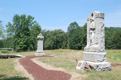
The trail proceeds toward the Bloody Angle and the monuments to the 49th New York and 15th New Jersey.
The trail then continues along the north face of the earthwork for about seventy-five yards, and comes to a sally port in the Confederate line, where a wooden bridge will provide conservation minded passage across, to the inside of the Salient.
The images below show the construction process of the segment heading up to the monuments from the parking area on Grant Drive.


Begun on Thursday, June 17, 2010, the designated path was marked on the grass with white paint, as seen on top. On Friday, June 18, the foundation for the trail was cut into place with heavy equipment, as seen in the bottom image.


On Monday June 21, and Tuesday, June 22, the trail foundation was further prepared with a base of gravel.

By 4:30 PM, on Wednesday, June 23, the laying of the rubber mulch surface had been completed, and left to cure in the sun. The mulch is made of recycled tires mixed with polyurethane, making a durable path.

The above image shows the construction looking west, along the face of the parapet, toward the monuments.

Here, the gravel bed is put in place.
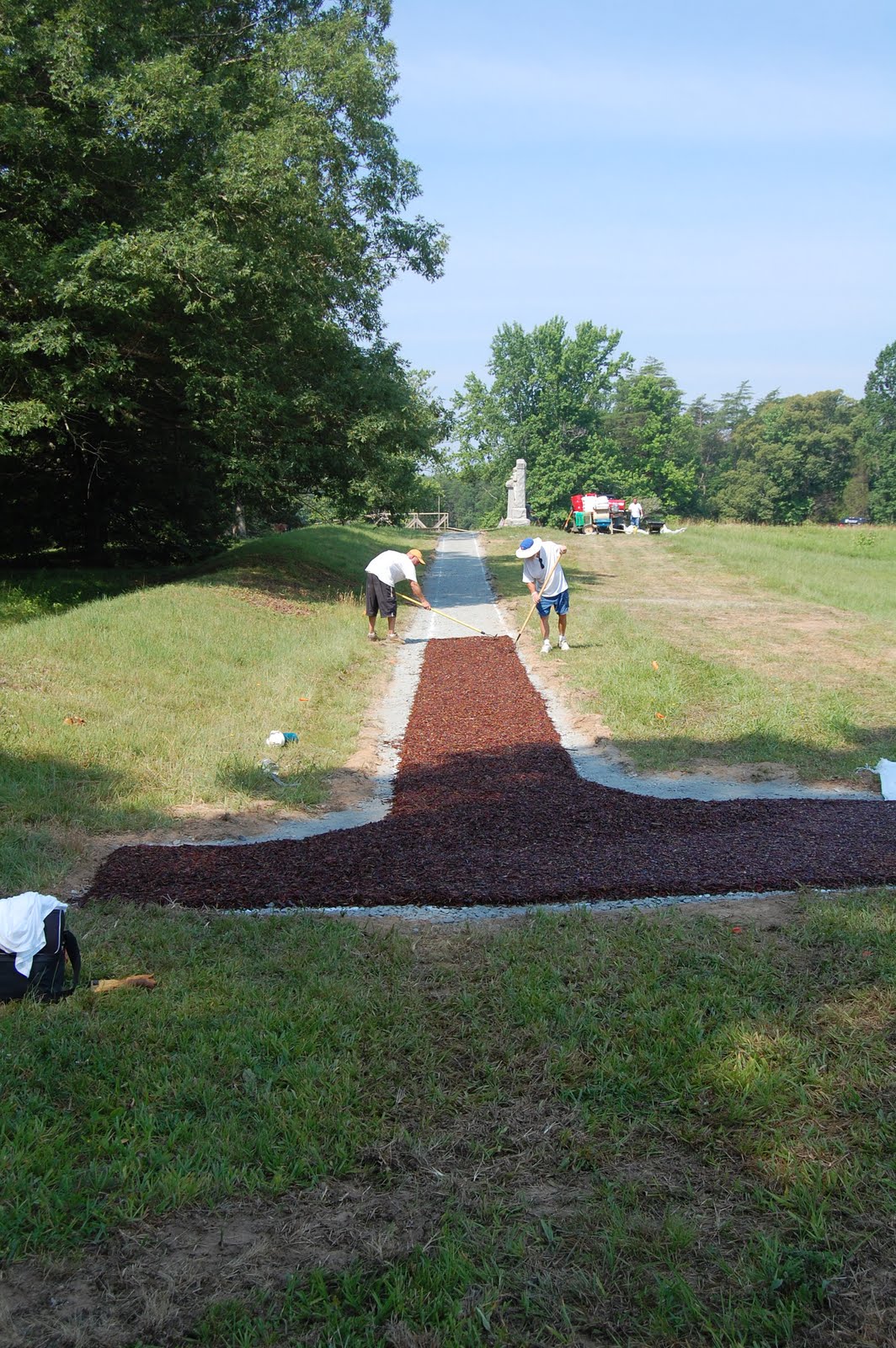

The mulch mixture is applied, rolled smooth, and left to cure.

By Thursday morning, June 24, the shoulders were refilled and seeded.
In a few weeks, most evidence of the construction process will be hard to detect. Interpretive signage will be stationed along the way. The foot bridge will be put in place to the left of the above image, enabling visitors to pass to the inside of the Salient without damage to the earthworks. The bridge which has been in place near the monuments will be removed, eliminating a long standing intrusion at the Bloody Angle.
Continued progress of this project will be posted at future dates. The picture below is taken from the Bloody Angle, looking east, toward the 15th New Jersey monument, on Thursday, June 24, 2010.

Seen below are the monuments with the parking area at center distance. The trail can be seen as it leads up to the Bloody Angle at the extreme left edge. The old bridge will be removed shortly.

Monday, June 14, 2010
Among Buildings Now Gone - Warehouses Along City Dock, Fredericksburg
Up until the 1930s, two, large, warehouse and tenement complexes dominated the 300 block of Sophia Street in Fredericksburg. In December of 1862, they would play an important role for some of the combatants of this infamous battle. Located just up from the City Dock area, these imposing structures provided temporary shelter for Union Brigades forming up prior to their advance through town, and onto the open ground in front of Marye's Heights. Today, a small memorial stands nearby, commemorating the men of the Irish Brigade. The detail images below, are taken from what is thought to be a May 1863, panoramic view of Fredericksburg, as seen from the Stafford County side of the Rappahannock River.
For our purposes here, we will call them "Complex A", the one furthest south, and "Complex B", nearer to the intersection with Frederick Street.

Complex A, looking abandoned and possibly showing effects of
the Union shelling of the town. Note what may be a puncture
through the brick wall between the upper floor windows, on
the left most portion of the main structure. Click picture for greater detail.

Complex B

Complex A, photographed in the late 1920s or early 1930s, by Frances Benjamin Johnston.
During this final stage of its existence, the buildings served as a "Pickle Factory." It is difficult to see if there is easily identifiable repair work to the brick wall, as mentioned in the description of the May 1863 view. Click picture for greater detail. Complex B is also visible from this angle, its northern most portion ending before the cluster of barren trees at right. Photograph from the Library of Congress, Prints & Photographs
Online Catalog.

Modern view of the Complex A site, showing how the City of Fredericksburg
has reclaimed the river front area for public park use. June 2010.

Complex B as seen in another view taken by noted
photographer Frances Benjamin Johnston. Here it functioned
as a "Hoop-Pole Factory." Photograph from the Library of Congress,
Prints & Photographs Online Catalog. 

The now empty landscape of Complex B.
June 2010
As quiet as it usually is today, it is sometimes hard to imagine the thousands of soldiers that stood in regimental marching order, shoulder to shoulder, here. Many never returned to this area alive after the fatal fighting of December 13, 1862. In May 1863 and 1864, the Union Army would return again to these sites as part of the Chancellorsville Campaign and the Overland Campaign, respectively.
Wednesday, June 9, 2010
Summer Is Almost Here - The Butterflies Are Back

Bull Thistle along the road to the McCoull House has attracted
a pair of Pipevine Swallowtail butterflies.

The Pipevine Swallowtail, up close.

A Tiger Swallowtail enjoys the Butterfly Weed near the
former CCC building on the McCoull Farm.

Honey bees also love Butterfly Weed.

Large crops of Butterfly Weed thrive on the battlefield.
Subscribe to:
Posts (Atom)